List of State Register of Heritage Places in the Town of East Fremantle
Map all coordinates using OpenStreetMap
Download coordinates as:
- KML
- GPX (all coordinates)
- GPX (primary coordinates)
- GPX (secondary coordinates)
The State Register of Heritage Places is maintained by the Heritage Council of Western Australia. As of 2024[update], 1,146 places are heritage-listed in the Town of East Fremantle,[1] of which fifteen are on the State Register of Heritage Places.[2]
List
The Western Australian State Register of Heritage Places, as of 2024[update], lists the following fifteen state registered places within the Town of East Fremantle:
| Place name | Place # | Street number | Street name | Suburb or town | Co-ordinates | Notes & former names | Photo |
|---|---|---|---|---|---|---|---|
| East Fremantle Post Office (former) | 787 | 101 | Canning Highway | East Fremantle | 32°02′28″S 115°45′45″E / 32.041225°S 115.762407°E / -32.041225; 115.762407 (East Fremantle Post Office) |  | |
| East Fremantle Town Hall | 788 | 135 | Canning Highway | East Fremantle | 32°02′28″S 115°45′47″E / 32.041210°S 115.763051°E / -32.041210; 115.763051 (East Fremantle Town Hall) | 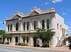 | |
| Public Buildings, East Fremantle | 789 | 101, 133 & 138 | Canning Highway | East Fremantle | 32°02′28″S 115°45′45″E / 32.041208°S 115.762595°E / -32.041208; 115.762595 (Public Buildings, East Fremantle) | East Fremantle Post Office, Police Station, Town, Mechanics Institute & Library & PO Group SES Headquarter | 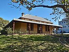 |
| Woodside Hospital | 792 | 18 | Dalgety Street | East Fremantle | 32°02′29″S 115°46′19″E / 32.041377°S 115.771808°E / -32.041377; 115.771808 (Woodside Hospital) | Moore Family Residence, Woodside |  |
| Royal George Hotel | 794 | 34 | Duke Street | East Fremantle | 32°02′38″S 115°45′48″E / 32.043929°S 115.763455°E / -32.043929; 115.763455 (Royal George Hotel) | Royal Hotel, Royal George Arts and Community Centre | 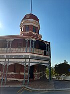 |
| Ferniehurst | 799 | 15 | Parker Street | East Fremantle | 32°01′56″S 115°45′59″E / 32.032126°S 115.766405°E / -32.032126; 115.766405 (Ferniehurst) | Ferryhurst, House & Gardens |  |
| Aldgate | 802 | 7 | Aldgate Place | East Fremantle | 32°02′16″S 115°45′55″E / 32.037716°S 115.765344°E / -32.037716; 115.765344 (Aldgate) |  | |
| Knocknagow | 803 | 24 | Preston Point Road | East Fremantle | 32°02′17″S 115°45′53″E / 32.038128°S 115.764741°E / -32.038128; 115.764741 (Knocknagow) | 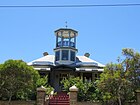 | |
| Woodlawn | 805 | 20 | Osborne Road | East Fremantle | 32°02′24″S 115°46′11″E / 32.039954°S 115.769818°E / -32.039954; 115.769818 (Woodlawn) | 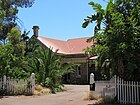 | |
| Glanville's Buildings | 3352 | 5A & 5B | Riverside Road | East Fremantle | 32°02′29″S 115°45′34″E / 32.041377°S 115.759327°E / -32.041377; 115.759327 (Glanville's Buildings) |  | |
| Penshurst | 3694 | 49, 51 & 53 | View Terrace | East Fremantle | 32°01′59″S 115°46′20″E / 32.033061°S 115.772158°E / -32.033061; 115.772158 (Penshurst) |  | |
| House, 26 King Street | 4645 | 26 | King Street | East Fremantle | 32°02′34″S 115°45′45″E / 32.042764°S 115.762431°E / -32.042764; 115.762431 (House, 26 King Street) |  | |
| Palm Trees | 10323 | 208 | Canning Highway | East Fremantle | 32°02′25″S 115°46′11″E / 32.040372°S 115.769829°E / -32.040372; 115.769829 (Palm Trees) | Part of Woodlawn Precinct (805) | 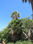 |
| East Fremantle Honour Roll, Council Offices | 12112 | 135 | Canning Highway | East Fremantle | 32°02′28″S 115°45′47″E / 32.041210°S 115.763051°E / -32.041210; 115.763051 (East Fremantle Honour Roll, Council Offices) | Part of Public Buildings, East Fremantle Precinct (789) | 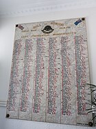 |
| Former Police Station | 24909 | 133 | Canning Highway | East Fremantle | 32°02′28″S 115°45′45″E / 32.041208°S 115.762595°E / -32.041208; 115.762595 (Former Police Station) |  |
References
- v
- t
- e
Heritage places of Western Australia by local government area
| Overview | |
|---|---|
| Cities | |
| Towns |
|
| Shires | |
| Islands |
- Beverley
- Brookton†
- Bruce Rock
- Chittering
- Corrigin
- Cuballing
- Cunderdin
- Dalwallinu
- Dandaragan†
- Dowerin†
- Dumbleyung†
- Gingin
- Goomalling
- Kellerberrin
- Kondinin
- Koorda†
- Kulin
- Lake Grace
- Merredin
- Moora
- Mount Marshall†
- Mukinbudin†
- Narembeen
- Narrogin
- Northam
- Nungarin
- Pingelly
- Quairading
- Tammin†
- Toodyay
- Trayning
- Victoria Plains
- Wagin
- Wandering†
- West Arthur
- Westonia
- Wickepin
- Williams
- Wongan-Ballidu
- Wyalkatchem
- Yilgarn
- York (Town of York • Shire of York)
| Organisations | |
|---|---|
| Register |
| Current |
|
|---|---|
| Former | |
^† Denotes LGA without State Heritage Listed Places | |


