List of State Register of Heritage Places in the City of Nedlands
List of heritage places in City of Nedlands, Western Australia
Map all coordinates using OpenStreetMap
Download coordinates as:
- KML
- GPX (all coordinates)
- GPX (primary coordinates)
- GPX (secondary coordinates)
The State Register of Heritage Places is maintained by the Heritage Council of Western Australia. As of 2024[update], of the places that are heritage-listed in the City of Nedlands,[1][note 1] 22 are on the State Register of Heritage Places.[2]
List
The Western Australian State Register of Heritage Places, as of 2024[update], lists the following 22 state registered places within the City of Nedlands:
| Place name | Place # | Street name & number | Suburb or town | Co-ordinates | Notes & former names | Photo |
|---|---|---|---|---|---|---|
| St Margaret's Anglican Church | 1830 | 52 Tyrell Street | Nedlands | 31°59′04″S 115°48′33″E / 31.984447°S 115.809231°E / -31.984447; 115.809231 (St Margaret's Anglican Church) | St Mary's (former) | 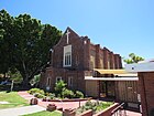 |
| Captain Stirling Hotel, Nedlands | 1832 | 80 Stirling Highway | Nedlands | 31°58′45″S 115°48′16″E / 31.9793°S 115.8044°E / -31.9793; 115.8044 (Captain Stirling Hotel) | 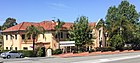 | |
| Lemnos Hospital | 1833 | Stubbs Terrace | Shenton Park | 31°57′37″S 115°48′13″E / 31.960384°S 115.803634°E / -31.960384; 115.803634 (Lemnos Hospital) | now part of Shenton College |  |
| Gallop House | 1834 | 21A Birdwood Parade | Dalkeith | 31°59′46″S 115°48′40″E / 31.996056°S 115.811079°E / -31.996056; 115.811079 (Gallop House) |  | |
| Tom Collins House, Allen Park | 2368 | 88 Woods Street | Swanbourne | 31°58′42″S 115°45′42″E / 31.978289°S 115.761748°E / -31.978289; 115.761748 (Tom Collins House) | Associated with the writer Joseph Furphy who rote under the pseudonym Tom Collins. Formerly located at 9 Servetus Street, Cottesloe (602) |  |
| Montgomery Hall | 2666 | St Johns Wood Boulevard | Mount Claremont | 31°57′42″S 115°46′57″E / 31.961552°S 115.782419°E / -31.961552; 115.782419 (Montgomery Hall) |  | |
| Administration Building Swanbourne Hospital | 2667 | Heritage Lane | Mount Claremont | 31°57′42″S 115°46′57″E / 31.961552°S 115.782419°E / -31.961552; 115.782419 (Administration Building) | Swanbourne Hospital (former) | |
| Shenton Park Rehabilitation Hospital | 2971 | 6 Selby Street | Shenton Park | 31°57′22″S 115°48′12″E / 31.956104°S 115.803246°E / -31.956104; 115.803246 (Shenton Park Rehabilitation Hospital) | Admin & Wards Block & Paraplegic Block, Royal Perth Rehabilitation, Shenton Park Annex | 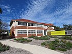 |
| The Maisonettes | 3227 | 67 Stirling Highway | Nedlands | 31°58′42″S 115°48′23″E / 31.978349°S 115.806433°E / -31.978349; 115.806433 (The Maisonettes) | 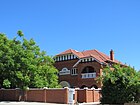 | |
| Swanbourne Hospital Conservation Area | 3228 | Lot 12040 St Johns Wood Boulevard | Mount Claremont | 31°57′41″S 115°46′55″E / 31.9615°S 115.782°E / -31.9615; 115.782 (Swanbourne Hospital) | 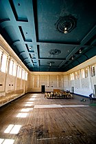 | |
| Sunset Hospital | 3374 | Birdwood Parade | Dalkeith | 32°00′04″S 115°48′13″E / 32.001239°S 115.803565°E / -32.001239; 115.803565 (Sunset Hospital) | Sunset Home, Old Men's Home |  |
| Nedlands Tennis Club | 3964 | Corner Bruce Street & Gallop Road | Nedlands | 31°59′31″S 115°48′36″E / 31.992020°S 115.810005°E / -31.992020; 115.810005 (Nedlands Tennis Club) | 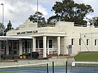 | |
| Hospital Director's Residence, Garage & Grounds | 3972 | St Johns Wood Boulevard | Mount Claremont | 31°57′41″S 115°46′55″E / 31.9615°S 115.782°E / -31.9615; 115.782 (Swanbourne Hospital) | ||
| St Lawrence's Anglican Church & Rectory | 4576 | Corner Viking & Alexander Roads | Dalkeith | 31°59′54″S 115°47′46″E / 31.998292°S 115.796072°E / -31.998292; 115.796072 (St Lawrence's Anglican Church & Rectory) | 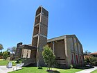 | |
| Nedlands Post Office (former) | 4620 | 35 Stirling Highway | Nedlands | 31°58′40″S 115°48′38″E / 31.977733°S 115.810479°E / -31.977733; 115.810479 (Nedlands Post Office) |  | |
| Chisholm House (former) | 4651 | 32 Genesta Crescent | Dalkeith | 31°59′51″S 115°47′47″E / 31.997484°S 115.796408°E / -31.997484; 115.796408 (Chisholm House) | Residence: 32 Genesta Crescent |  |
| Nedlands War Memorial | 13617 | Corner Waratah Avenue & Birdwood Parade | Dalkeith | 31°59′41″S 115°48′38″E / 31.994720°S 115.810581°E / -31.994720; 115.810581 (Nedlands War Memorial) | Dalkeith War Memorial, Waratah Avenue War Memorial | 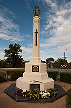 |
| Graylands Hospital | 13630 | Brockway Road | Mount Claremont | 31°57′43″S 115°47′22″E / 31.961929°S 115.78934°E / -31.961929; 115.78934 (Graylands Hospital) | Swanbourne Hospital, Claremont Hospital for the Insane |  |
| David Foulkes-Taylor Showroom (former) | 13655 | 2/31 Broadway | Nedlands | 31°58′43″S 115°48′50″E / 31.978505°S 115.813957°E / -31.978505; 115.813957 (David Foulkes-Taylor Showroom) | Watersmart Building, Jim Brant Building, Mojo Australia, designed by Julius Elischer |  |
| Peace Memorial Rose Garden | 13668 | Stirling Highway | Nedlands | 31°58′51″S 115°47′58″E / 31.9807°S 115.7995°E / -31.9807; 115.7995 (Peace Memorial Rose Garden) |  | |
| Tudor Style Shops - Renkema Building | 13700 | 134 Stirling Highway | Nedlands | 31°58′49″S 115°47′52″E / 31.980374°S 115.797718°E / -31.980374; 115.797718 (Tudor Style Shops - Renkema Building) | Designed by the well-known architect Edwin Summerhayes | |
| Mattie Furphy's House | 13705 | 11 Kirkwood Road | Swanbourne | 31°58′43″S 115°45′42″E / 31.978652°S 115.761658°E / -31.978652; 115.761658 (Mattie Furphy's House) | Associated with the writer Joseph Furphy who rote under the pseudonym Tom Collins. Formerly located at 74 Clement Street |  |
Notes
- ^ The search result for non-State Register of Heritage Places in the City of Nedlands produces no result, displaying only an error message
References
- v
- t
- e
Heritage places of Western Australia by local government area
| Overview | |
|---|---|
| Cities | |
| Towns | |
| Shires | |
| Islands |
- Beverley
- Brookton†
- Bruce Rock
- Chittering
- Corrigin
- Cuballing
- Cunderdin
- Dalwallinu
- Dandaragan†
- Dowerin†
- Dumbleyung†
- Gingin
- Goomalling
- Kellerberrin
- Kondinin
- Koorda†
- Kulin
- Lake Grace
- Merredin
- Moora
- Mount Marshall†
- Mukinbudin†
- Narembeen
- Narrogin
- Northam
- Nungarin
- Pingelly
- Quairading
- Tammin†
- Toodyay
- Trayning
- Victoria Plains
- Wagin
- Wandering†
- West Arthur
- Westonia
- Wickepin
- Williams
- Wongan-Ballidu
- Wyalkatchem
- Yilgarn
- York (Town of York • Shire of York)
| Organisations | |
|---|---|
| Register |
| Current |
|
|---|---|
| Former | |
^† Denotes LGA without State Heritage Listed Places | |


