List of Category A listed buildings in North Ayrshire

Map all coordinates using OpenStreetMap
Download coordinates as:
- KML
- GPX (all coordinates)
- GPX (primary coordinates)
- GPX (secondary coordinates)
This is a list of Category A listed buildings in the North Ayrshire council area in Scotland.
In Scotland, the term listed building refers to a building or other structure officially designated as being of "special architectural or historic interest".[1] Category A structures are those considered to be "buildings of national or international importance, either architectural or historic, or fine little-altered examples of some particular period, style or building type."[2] Listing was begun by a provision in the Town and Country Planning (Scotland) Act 1947, and the current legislative basis for listing is the Planning (Listed Buildings and Conservation Areas) (Scotland) Act 1997.[3] The authority for listing rests with Historic Scotland, an executive agency of the Scottish Government, which inherited this role from the Scottish Development Department in 1991. Once listed, severe restrictions are imposed on the modifications allowed to a building's structure or its fittings. Listed building consent must be obtained from local authorities prior to any alteration to such a structure.[3] There are approximately 47,400 listed buildings in Scotland, of which around 8% (some 3,800) are Category A.[4]
The council area of North Ayrshire covers 885 square kilometres (342 sq mi), including the Isle of Arran, and has a population of around 135,200. There are 41 Category A listed buildings in the area.
Listed buildings
| Name | Location | Date Listed | Grid Ref. [note 1] | Geo-coordinates | Notes | LB Number [note 2] | Image |
|---|---|---|---|---|---|---|---|
| Annick Lodge | Irvine | NS3586341846 | 55°38′33″N 4°36′34″W / 55.642363°N 4.60954°W / 55.642363; -4.60954 (Annick Lodge) | [5] | 836 |  Upload Photo | |
| Little Cumbrae Castle | Little Cumbrae, Castle Island | NS1524851348 | 55°43′13″N 4°56′35″W / 55.720229°N 4.943037°W / 55.720229; -4.943037 (Little Cumbrae Castle) | [6] | 853 | 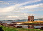 Upload another image | |
| Woodside House | Beith | NS3475255411 | 55°45′49″N 4°38′07″W / 55.763741°N 4.635359°W / 55.763741; -4.635359 (Woodside House) | [7] | 943 |  Upload another image | |
| Blair House | Dalry | NS3045348034 | 55°41′46″N 4°41′57″W / 55.696044°N 4.699218°W / 55.696044; -4.699218 (Blair House) | [8] | 1196 | Upload Photo | |
| Swindridgemuir | Dalry | NS3195849842 | 55°42′46″N 4°40′35″W / 55.712795°N 4.676411°W / 55.712795; -4.676411 (Swindridgemuir) | [9] | 1254 | Upload Photo | |
| Lamp near main door of Skelmorlie Parish Church | Skelmorlie | NS1928668130 | 55°52′20″N 4°53′24″W / 55.872346°N 4.889981°W / 55.872346; -4.889981 (Lamp near main door of Skelmorlie Parish Church) | [10] | 7270 |  Upload another image | |
| Kelburn Castle | Fairlie | NS2171056704 | 55°46′15″N 4°50′38″W / 55.770714°N 4.843796°W / 55.770714; -4.843796 (Kelburn Castle) | [11] | 7294 |  Upload another image | |
| Kelburn Castle, monument to John, 3rd Earl of Glasgow | Fairlie | NS2189056714 | 55°46′15″N 4°50′27″W / 55.77087°N 4.840937°W / 55.77087; -4.840937 (Kelburn Castle, monument to John, 3rd Earl of Glasgow) | [12] | 7295 | 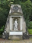 Upload another image | |
| Kelburn Castle, sundial to west of house | Fairlie | NS2169556706 | 55°46′15″N 4°50′39″W / 55.770726°N 4.844036°W / 55.770726; -4.844036 (Kelburn Castle, sundial to west of house) | [13] | 7298 | Upload another image | |
| Knock Castle | Largs | NS1940462998 | 55°49′35″N 4°53′05″W / 55.826338°N 4.884681°W / 55.826338; -4.884681 (Knock Castle) | [14] | 7306 |  Upload another image | |
| Kilbirnie Auld Kirk | Kilbirnie | NS3147353647 | 55°44′48″N 4°41′11″W / 55.746777°N 4.686468°W / 55.746777; -4.686468 (Kilbirnie Auld Kirk) | [15] | 7492 |  Upload another image | |
| Ladyland House Sundial | Kilbirnie | NS3220957877 | 55°47′06″N 4°40′38″W / 55.784998°N 4.677359°W / 55.784998; -4.677359 (Ladyland House Sundial) | [16] | 7499 |  Upload another image | |
| Brodick Castle | Arran | NS0155837866 | 55°35′38″N 5°09′03″W / 55.593863°N 5.1509°W / 55.593863; -5.1509 (Brodick Castle) | [17] | 7507 |  Upload another image | |
| Brodick Castle Walled Garden | Arran | NS0167137876 | 55°35′38″N 5°08′57″W / 55.593998°N 5.149117°W / 55.593998; -5.149117 (Brodick Castle Walled Garden) | [18] | 7508 |  Upload another image | |
| Ladyland House | Kilbirnie | NS3219657840 | 55°47′05″N 4°40′39″W / 55.784661°N 4.677543°W / 55.784661; -4.677543 (Ladyland House) | [19] | 7532 |  Upload another image | |
| Montgreenan | Kilwinning | NS3432344519 | 55°39′57″N 4°38′08″W / 55.665832°N 4.635593°W / 55.665832; -4.635593 (Montgreenan) | [20] | 7577 |  Upload another image | |
| St. Molio's Church | Arran, Shiskine | NR9099629419 | 55°30′49″N 5°18′43″W / 55.513672°N 5.31183°W / 55.513672; -5.31183 (St. Molio's Church) | [21] | 7635 |  Upload another image | |
| 1–27 (inclusive nos) Hamilton Terrace | Arran, Lamlash | NS0269431133 | 55°32′02″N 5°07′41″W / 55.533916°N 5.128093°W / 55.533916; -5.128093 (1–27 (inclusive nos) Hamilton Terrace) | [22] | 13234 | 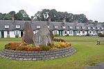 Upload another image | |
| Lamlash and Kilbride Parish Church | Arran, Lamlash | NS0256930939 | 55°31′56″N 5°07′48″W / 55.532125°N 5.129932°W / 55.532125; -5.129932 (Lamlash and Kilbride Parish Church) | [23] | 13441 |  Upload another image | |
| Law Castle | West Kilbride | NS2109448416 | 55°41′46″N 4°50′53″W / 55.69611°N 4.848177°W / 55.69611; -4.848177 (Law Castle) | [24] | 14279 | 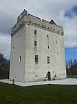 Upload another image | |
| Sundial, Kirktonhall | West Kilbride, Glen Road | NS2052148272 | 55°41′41″N 4°51′26″W / 55.694606°N 4.857187°W / 55.694606; -4.857187 (Sundial, Kirktonhall) | [25] | 14309 |  Upload another image | |
| Hunterston Castle | Hunterston | NS1928551471 | 55°43′22″N 4°52′44″W / 55.722855°N 4.878937°W / 55.722855; -4.878937 (Hunterston Castle) | [26] | 14313 |  Upload another image | |
| St Peter-in-Chains RC Church | Ardrossan, South Crescent Road | NS2329242155 | 55°38′27″N 4°48′33″W / 55.640728°N 4.80922°W / 55.640728; -4.80922 (St Peter-in-Chains RC Church) | [27] | 21335 |  Upload another image | |
| Irvine Old Parish Church and Graveyard | Irvine, Kirkgate | NS3220538672 | 55°36′45″N 4°39′56″W / 55.612625°N 4.665657°W / 55.612625; -4.665657 (Irvine Old Parish Church and Graveyard) | [28] | 35409 | 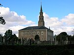 Upload another image | |
| Trinity Church | Irvine, Bridgegate | NS3203038801 | 55°36′49″N 4°40′07″W / 55.613723°N 4.66851°W / 55.613723; -4.66851 (Trinity Church) | [29] | 35410 |  Upload another image | |
| Linthouse Building, Scottish Maritime Museum | Irvine, Montgomery Street | NS3135438542 | 55°36′40″N 4°40′45″W / 55.611164°N 4.679072°W / 55.611164; -4.679072 (Linthouse Building, Scottish Maritime Museum) | [30] | 35450 | 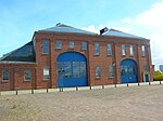 Upload another image | |
| SV Carrick, Scottish Maritime Museum | Irvine, Montgomery Street | NS3135038630 | 55°36′43″N 4°40′45″W / 55.611953°N 4.679189°W / 55.611953; -4.679189 (SV Carrick, Scottish Maritime Museum) | [31] | 35451 | Upload Photo | |
| Kilwinning Abbey | Kilwinning | NS3032443274 | 55°39′12″N 4°41′54″W / 55.653277°N 4.698324°W / 55.653277; -4.698324 (Kilwinning Abbey) | [32] | 36237 |  Upload another image | |
| Clark Memorial Church | Largs, Bath Street | NS2016659316 | 55°47′37″N 4°52′12″W / 55.793582°N 4.870099°W / 55.793582; -4.870099 (Clark Memorial Church) | [33] | 37152 | 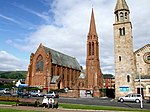 Upload another image | |
| Brooksby Convalescent Home | Largs, Greenock Road | NS2032859792 | 55°47′52″N 4°52′04″W / 55.797913°N 4.867833°W / 55.797913; -4.867833 (Brooksby Convalescent Home) | [34] | 37165 |  Upload another image | |
| Skelmorlie Aisle | Largs | NS2026559441 | 55°47′41″N 4°52′07″W / 55.79474°N 4.868605°W / 55.79474; -4.868605 (Skelmorlie Aisle) | [35] | 37198 |  Upload another image | |
| Brisbane Aisle | Largs | NS2024759447 | 55°47′41″N 4°52′08″W / 55.794787°N 4.868896°W / 55.794787; -4.868896 (Brisbane Aisle) | [36] | 37199 |  Upload another image | |
| Cathedral of The Isles and Collegiate Church of the Holy Spirit | Great Cumbrae, Millport | NS1657755240 | 55°45′20″N 4°55′28″W / 55.755658°N 4.924522°W / 55.755658; -4.924522 (Cathedral of The Isles and Collegiate Church of the Holy Spirit) | [37] | 37824 |  Upload another image | |
| Seamill Centre, formerly Seamill House | Seamill | NS2044847223 | 55°41′07″N 4°51′28″W / 55.685166°N 4.85766°W / 55.685166; -4.85766 (Seamill Centre, formerly Seamill House) | [38] | 43209 | Upload Photo | |
| Mercat Cross | Kilwinning | NS3045343352 | 55°39′14″N 4°41′47″W / 55.654022°N 4.696324°W / 55.654022; -4.696324 (Mercat Cross) | [39] | 47598 |  Upload another image | |
| Brodick Castle, Bavarian Summerhouse | Arran | NS0168337725 | 55°35′34″N 5°08′56″W / 55.592648°N 5.148818°W / 55.592648; -5.148818 (Brodick Castle, Bavarian Summerhouse) | [40] | 47599 |  Upload another image |
See also
Notes
- ^ Sometimes known as OSGB36, the grid reference (where provided) is based on the British national grid reference system used by the Ordnance Survey.
• "Guide to National Grid". Ordnance Survey. Retrieved 12 December 2007.
• "Get-a-map". Ordnance Survey. Retrieved 17 December 2007. - ^ Historic Environment Scotland assign a unique alphanumeric identifier to each designated site in Scotland, for listed buildings this always begins with "LB", for example "LB12345".
References
- ^ Guide to the Protection of Scotland’s Listed Buildings (PDF). Historic Scotland. 2009. p. 4. ISBN 978-1-84917-013-0. Retrieved 5 May 2010.
- ^ "What is Listing?". Historic Scotland. Retrieved 5 May 2010.
- ^ a b Scottish Historic Environment Policy (PDF). Historic Scotland. October 2008. pp. 24–25. ISBN 978-1-84917-002-4. Retrieved 5 May 2010.
- ^ Guide to the Protection of Scotland’s Listed Buildings, p. 17.
- ^ "Annick Lodge: Listed Building Report". Historic Scotland.
- ^ "Little Cumbrae Castle: Listed Building Report". Historic Scotland.
- ^ "Woodside House, Including Boundary Walls And Gatepiers: Listed Building Report". Historic Scotland.
- ^ "Blair House: Listed Building Report". Historic Scotland.
- ^ "Swindridgemuir: Listed Building Report". Historic Scotland.
- ^ "Skelmorlie Village Skelmorlie Parish Church Lamp Near Main Door: Listed Building Report". Historic Scotland.
- ^ "Kelburn Castle Walled Courtyard To North And Gatepiers: Listed Building Report". Historic Scotland.
- ^ "Kelburn Monument To John, 3rd Earl Of Glasgow: Listed Building Report". Historic Scotland.
- ^ "Kelburn Sundial To West Of House: Listed Building Report". Historic Scotland.
- ^ "Knock Castle And Garden Pavilion Block And Gatepiers To East: Listed Building Report". Historic Scotland.
- ^ "Kilbirnie Auld Kirk And Cemetery Walls: Listed Building Report". Historic Scotland.
- ^ "Ladyland House Sundial: Listed Building Report". Historic Scotland.
- ^ "Brodick Castle: Listed Building Report". Historic Scotland.
- ^ "Walled Garden And Formal Layout With Centre Sundial: Listed Building Report". Historic Scotland.
- ^ "Ladyland House And Gatepiers: Listed Building Report". Historic Scotland.
- ^ "Montgreenan: Listed Building Report". Historic Scotland.
- ^ "St. Molio's Church Shiskine: Listed Building Report". Historic Scotland.
- ^ "Lamlash 1-27 (Inclusive Nos) Hamilton Terrace Including Garden Enclosures: Listed Building Report". Historic Scotland.
- ^ "Lamlash, Lamlash And Kilbride Parish Church, Including Cross And Baptismal Font, Former Closet, Boundary Wall, Piers And Railings: Listed Building Report". Historic Scotland.
- ^ "Law Castle: Listed Building Report". Historic Scotland.
- ^ "Sundial, Kirktonhall: Listed Building Report". Historic Scotland.
- ^ "Hunterston Castle: Listed Building Report". Historic Scotland.
- ^ "St Peter-In-Chains RC Church Pavilion Place And South Crescent: Listed Building Report". Historic Scotland.
- ^ "Kirkgate, Irvine Old Parish Church And Graveyard, Including Boundary Walls And Gatepiers: Listed Building Report". Historic Scotland.
- ^ "Bridgegate, Trinity Church, Latterly Community Centre, With Hall, Approach Wall, Piers And Railings: Listed Building Report". Historic Scotland.
- ^ "Gottries Road, Linthouse Building, Scottish Maritime Museum: Listed Building Report". Historic Scotland.
- ^ "Harbour Street, Scottish Maritime Museum, Sv Carrick: Listed Building Report". Historic Scotland.
- ^ "Kilwinning Abbey: Listed Building Report". Historic Scotland.
- ^ "Bath Street, Clark Memorial Church And Gatepiers: Listed Building Report". Historic Scotland.
- ^ "Greenock Road Brooksby Convalescent Home And Gatepiers: Listed Building Report". Historic Scotland.
- ^ "Skelmorlie Aisle And Cemetery Wall And Gate Piers: Listed Building Report". Historic Scotland.
- ^ "Skelmorlie Aisle, Brisbane Aisle: Listed Building Report". Historic Scotland.
- ^ "Episcopal Cathedral With Collegiate Buildings And Cloister: Listed Building Report". Historic Scotland.
- ^ "Seamill Centre, Formerly Seamill House, With Lodge, Boundary Walls And Gatepiers: Listed Building Report". Historic Scotland.
- ^ "Mercat Cross: Listed Building Report". Historic Scotland.
- ^ "Bavarian Summerhouse: Listed Building Report". Historic Scotland.
External links
![]() Media related to Category A listed buildings in North Ayrshire at Wikimedia Commons
Media related to Category A listed buildings in North Ayrshire at Wikimedia Commons
- v
- t
- e
- City of Aberdeen
- Aberdeenshire
- Angus
- Argyll and Bute
- Clackmannanshire
- Dumfries and Galloway
- City of Dundee
- East Ayrshire
- East Dunbartonshire
- East Lothian
- East Renfrewshire
- City of Edinburgh
- Falkirk
- Fife
- City of Glasgow
- Highland
- Inverclyde
- Midlothian
- Moray
- North Ayrshire
- North Lanarkshire
- Orkney
- Perth and Kinross
- Renfrewshire
- Scottish Borders
- Shetland
- South Ayrshire
- South Lanarkshire
- Stirling
- West Dunbartonshire
- West Lothian
- Western Isles (na h-Eileanan Siar)


