List of Category A listed buildings in Argyll and Bute

Map all coordinates using OpenStreetMap
Download coordinates as:
- KML
- GPX (all coordinates)
- GPX (primary coordinates)
- GPX (secondary coordinates)
This is a list of Category A listed buildings in Argyll and Bute, Scotland.
In Scotland, the term listed building refers to a building or other structure officially designated as being of "special architectural or historic interest".[1] Category A structures are those considered to be "buildings of national or international importance, either architectural or historic, or fine little-altered examples of some particular period, style or building type."[2] Listing was begun by a provision in the Town and Country Planning (Scotland) Act 1947, and the current legislative basis for listing is the Planning (Listed Buildings and Conservation Areas) (Scotland) Act 1997.[3] The authority for listing rests with Historic Environment Scotland, an executive agency of the Scottish Government, which inherited this role from the Scottish Development Department in 1991. Once listed, severe restrictions are imposed on the modifications allowed to a building's structure or its fittings. Listed building consent must be obtained from local authorities prior to any alteration to such a structure.[3] There are approximately 47,400 listed buildings in Scotland, of which around 8% (some 3,800) are Category A.[4] The council area of Argyll and Bute covers 6,909 square kilometres (2,668 sq mi), and has a population of around 90,500. There are 2,031 listed buildings in the area, of which approximately 150 are Category A.[5]
Listed buildings
| Name | Location | Date Listed | Grid Ref. [note 1] | Geo-coordinates | Notes | LB Number [note 2] | Image |
|---|---|---|---|---|---|---|---|
| St Conan's Church | Lochawe village | NN1159526743 | 56°23′43″N 5°03′15″W / 56.395269°N 5.05416°W / 56.395269; -5.05416 (St Conan's Church) | 19th-century church with early-20th-century additions[6] | 4700 |  Upload another image | |
| Old Breachacha Castle | Coll | NM1599053910 | 56°35′27″N 6°37′41″W / 56.590813°N 6.628042°W / 56.590813; -6.628042 (Old Breachacha Castle) | Mid-15th-century castle, restored from a ruin in the 1960s[7] | 4708 | 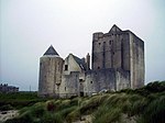 Upload another image | |
| Breachacha Castle | Coll | NM1589554015 | 56°35′30″N 6°37′47″W / 56.591696°N 6.629699°W / 56.591696; -6.629699 (Breachacha Castle) | Mid-18th-century manor house[8] | 4709 |  Upload another image | |
| Lochnell House | Ardmucknish Bay, Benderloch | NM8859138978 | 56°29′43″N 5°26′10″W / 56.495262°N 5.436059°W / 56.495262; -5.436059 (Lochnell House) | Georgian country house, rebuilt in the late 19th century[9] | 4716 |  Upload Photo | |
| Lochnell Observatory (Lady Margaret's Tower) | Lochnell Estate, Benderloch | NM8822438337 | 56°29′22″N 5°26′29″W / 56.489349°N 5.441488°W / 56.489349; -5.441488 (Lochnell Observatory (Lady Margaret's Tower)) | 19th-century folly[10] | 4717 |  Upload another image | |
| Barcaldine Castle | Benderloch | NM9079340576 | 56°30′38″N 5°24′06″W / 56.510577°N 5.401642°W / 56.510577; -5.401642 (Barcaldine Castle) | Late-16th-century tower house, restored in the late 19th century[11] | 4719 |  Upload another image | |
| Barbreck House | Ardfern | NM8308606403 | 56°12′02″N 5°29′54″W / 56.200649°N 5.498428°W / 56.200649; -5.498428 (Barbreck House) | Georgian country house of 1790[12] | 4996 |  Upload another image | |
| St Munn's Parish Church | Kilmun | NS1659282073 | 55°59′47″N 4°56′33″W / 55.996438°N 4.942453°W / 55.996438; -4.942453 (St Munn's Parish Church) | 19th-century church on an earlier site, contains Campbell of Argyll and Douglas of Glenfinart mausolea, and a good collection of post-medieval headstones[13] | 5073 |  Upload another image | |
| Dunselma | Strone | NS1920380729 | 55°59′07″N 4°53′59″W / 55.985369°N 4.899743°W / 55.985369; -4.899743 (Dunselma) | Late-19th-century Scots Baronial country house[14] | 5075 | Upload Photo | |
| Oronsay Priory | Oronsay, Inner Hebrides | NR3496288948 | 56°01′12″N 6°15′17″W / 56.019915°N 6.254704°W / 56.019915; -6.254704 (Oronsay Priory) | 14th-century Augustinian monastery, now in ruins[15] | 5086 | 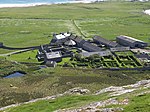 Upload another image | |
| Oronsay Great Cross | Oronsay | NR3498688942 | 56°01′12″N 6°15′16″W / 56.019874°N 6.254314°W / 56.019874; -6.254314 (Oronsay Great Cross) | Carved stone cross dating to 1510[16] | 5087 |  Upload another image | |
| Golden Gates, Benmore Botanic Garden | Strath Eachaig, north of the Holy Loch | NS1376785047 | 56°01′19″N 4°59′23″W / 56.022033°N 4.989744°W / 56.022033; -4.989744 (Golden Gates, Benmore Botanic Garden) | 19th-century gates, "an example of exceptional wrought iron work"[17] | 6438 | 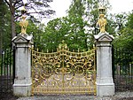 Upload another image | |
| St Peter's College | Cardross | NS3530478404 | 55°58′13″N 4°38′26″W / 55.9703°N 4.640546°W / 55.9703; -4.640546 (St Peter's College) | 1960s Roman Catholic seminary by Gillespie, Kidd and Coia, now in ruins[18] | 6464 |  Upload another image | |
| Old Kilmun House | Kilmun | NS1653282182 | 55°59′51″N 4°56′37″W / 55.997393°N 4.943488°W / 55.997393; -4.943488 (Old Kilmun House) | Early-18th-century house with later additions[19] | 6582 | Upload Photo | |
| Auchindrain Township | Auchindrain | NN0309903161 | 56°10′49″N 5°10′26″W / 56.180266°N 5.173984°W / 56.180266; -5.173984 (Auchindrain Township) | Preserved settlement of 18th- and 19th-century vernacular buildings, operated as a museum[20] | 6798 |  Upload another image | |
| Carnasserie Castle | Kilmartin | NM8390800848 | 56°09′04″N 5°28′50″W / 56.151207°N 5.480688°W / 56.151207; -5.480688 (Carnasserie Castle) | Later 16th-century tower house with Renaissance detailing[21] | 11454 | 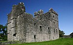 Upload another image | |
| Maam Steading | Glen Shira, Inveraray Castle Estate | NN1221412765 | 56°16′12″N 5°02′03″W / 56.270112°N 5.034171°W / 56.270112; -5.034171 (Maam Steading) | Semi-circular Gothic revival steading, 1790, by Robert Mylne[22] | 11518 | Upload Photo | |
| Cherrypark | Inveraray Castle | NN0931609227 | 56°14′14″N 5°04′42″W / 56.237216°N 5.078345°W / 56.237216; -5.078345 (Cherrypark) | Castle offices, stables and coachmans house, circa 1760 by John Adam[23] | 11528 | Upload Photo | |
| Doocot | Carloonan, Inveraray Castle Estate | NN0880110601 | 56°14′58″N 5°05′15″W / 56.249336°N 5.087633°W / 56.249336; -5.087633 (Doocot) | 18th-century dovecote by Roger Morris[24] | 11540 |  Upload another image | |
| Watch Tower | Dùn Na Cuaiche, Inveraray Castle Estate | NN1003410124 | 56°14′44″N 5°04′03″W / 56.245551°N 5.067422°W / 56.245551; -5.067422 (Watch Tower) | 18th-century Gothic revival folly, overlooking the castle[25] | 11543 | 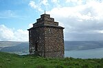 Upload another image | |
| Garden Bridge | Inveraray Castle gardens | NN0953809491 | 56°14′23″N 5°04′30″W / 56.239673°N 5.074958°W / 56.239673; -5.074958 (Garden Bridge) | Bridge over the River Aray, circa 1761 by John Adam[26] | 11544 | 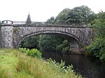 Upload another image | |
| Aray Bridge | Mouth of the River Aray, Inveraray Castle Estate | 1971 | NN0981609052 | 56°14′09″N 5°04′13″W / 56.235846°N 5.070164°W / 56.235846; -5.070164 (Aray Bridge) | Bridge carrying the A83 road over the River Aray, designed by Robert Mylne in 1775[27] | 11545 |  Upload another image |
| Garron Lodge | By Garron Bridge, Glen Shira, Inveraray Castle Estate | NN1134210134 | 56°14′46″N 5°02′47″W / 56.246162°N 5.046353°W / 56.246162; -5.046353 (Garron Lodge) | Lodge designed by Robert Mylne in 1775[28] | 11548 | Upload Photo | |
| Garron Screen Wall | By Garron Bridge, Glen Shira, Inveraray Castle Estate | NN1135710123 | 56°14′46″N 5°02′46″W / 56.246069°N 5.046104°W / 56.246069; -5.046104 (Garron Screen Wall) | Screen wall between bridge and lodge, designed by Robert Mylne in 1775[29] | 11549 | Upload Photo | |
| Garron Bridge | Glen Shira, Inveraray Castle Estate | NN1139510097 | 56°14′45″N 5°02′44″W / 56.245851°N 5.045473°W / 56.245851; -5.045473 (Garron Bridge) | 18th-century hump-back bridge carrying the A83 road over the River Shira, designed by Roger Morris[30] | 11550 | 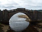 Upload another image | |
| Dubh Loch Bridge | Glen Shira, Inveraray Castle Estate | NN1139810542 | 56°14′59″N 5°02′45″W / 56.249844°N 5.045742°W / 56.249844; -5.045742 (Dubh Loch Bridge) | 18th-century bridge over the River Shira by Robert Mylne[31] | 11551 | Upload Photo | |
| Inveraray Castle | Inveraray | NN0961309241 | 56°14′15″N 5°04′25″W / 56.237461°N 5.07357°W / 56.237461; -5.07357 (Inveraray Castle) | 18th-century Gothic revival country house, designed by Roger Morris and built by William Adam[32] | 11552 | 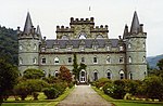 Upload another image | |
| St Columba's Monastery | Eileach an Naoimh, Garvellachs | NM6401709724 | 56°13′17″N 5°48′29″W / 56.221352°N 5.808057°W / 56.221352; -5.808057 (St Columba's Monastery) | Ruins of several early Christian buildings, identified with the monastery of Hinba founded by St. Brendan in 542[33] | 11587 | 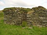 Upload another image | |
| Dunderave Castle | North shore of Loch Fyne | NN1432309648 | 56°14′35″N 4°59′53″W / 56.242975°N 4.997977°W / 56.242975; -4.997977 (Dunderave Castle) | Late-16th-century tower house, restored by Sir Robert Lorimer 1911–1912[34] | 11769 |  Upload another image | |
| Dunans Bridge | Dunans Castle, Glendaruel | NS0404891254 | 56°04′26″N 5°09′00″W / 56.073841°N 5.149968°W / 56.073841; -5.149968 (Dunans Bridge) | 19th-century bridge giving access to Dunans Castle[35] | 11806 |  Upload another image | |
| Sundial at Ormidale House | Mouth of Glendaruel | NS0020081700 | 55°59′12″N 5°12′16″W / 55.986545°N 5.204571°W / 55.986545; -5.204571 (Sundial at Ormidale House) | 18th-century sundial[36] | 11810 |  Upload another image | |
| Carrick Castle | West shore of Loch Goil | NS1941694481 | 56°06′32″N 4°54′20″W / 56.108847°N 4.905602°W / 56.108847; -4.905602 (Carrick Castle) | Late-14th-century tower with later additions[37] | 11815 |  Upload another image | |
| Kilmorich Kirk | Cairndow | NN1805410744 | 56°15′15″N 4°56′19″W / 56.254252°N 4.938611°W / 56.254252; -4.938611 (Kilmorich Kirk) | Early-19th-century Gothic revival church[38] | 11818 | 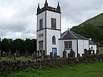 Upload another image | |
| Clachan Bridge | Sound of Seil | NM7853219693 | 56°19′04″N 5°34′58″W / 56.317721°N 5.582814°W / 56.317721; -5.582814 (Clachan Bridge) | 18th-century bridge linking Seil to the mainland[39] | 11834 | 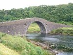 Upload another image | |
| Rhinns Of Islay Lighthouse | Orsay, off the Rinns of Islay | NR1634551414 | 55°40′23″N 6°30′48″W / 55.673081°N 6.513232°W / 55.673081; -6.513232 (Rhinns Of Islay Lighthouse) | Early-19th-century lighthouse by Robert Stevenson[40] | 11944 |  Upload another image | |
| Dunstaffnage Castle | Mouth of Loch Etive, west of Connel | Not listed | NS8826634491 | 55°35′28″N 3°46′28″W / 55.591189°N 3.774474°W / 55.591189; -3.774474 (Dunstaffnage Castle) | 13th-century curtain-wall castle[41] | 11987 |  Upload another image |
| Dunstaffnage Chapel | Adjacent to Dunstaffnage Castle | NS8808134412 | 55°35′26″N 3°46′39″W / 55.590437°N 3.777376°W / 55.590437; -3.777376 (Dunstaffnage Chapel) | 13th-century chapel, now ruined[42] | 11988 | 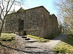 Upload another image | |
| Killean Chapel | Killean, Kintyre | NR6951544573 | 55°38′24″N 5°39′50″W / 55.639896°N 5.663962°W / 55.639896; -5.663962 (Killean Chapel) | Medieval chapel and burial ground, now in ruins[43] | 12004 | Upload Photo | |
| Killean House | Killean, Kintyre | NR6965944281 | 55°38′14″N 5°39′41″W / 55.637346°N 5.661435°W / 55.637346; -5.661435 (Killean House) | Late-19th-century country house[44] | 12005 |  Upload another image | |
| Killean And Kilchenzie Kirk | A'Chleit, Kintyre | NR6812541806 | 55°36′52″N 5°41′01″W / 55.614425°N 5.683667°W / 55.614425; -5.683667 (Killean And Kilchenzie Kirk) | 18th-century church[45] | 12035 |  Upload another image | |
| Mount Stuart House | Isle of Bute | NM1084359499 | 56°38′16″N 6°43′04″W / 56.637711°N 6.717817°W / 56.637711; -6.717817 (Mount Stuart House) | Gothic country house by Robert Rowand Anderson, 1878[46] | 12052 |  Upload another image | |
| Mount Stuart, Mausoleum And Graveyard | Isle of Bute | NM1101260563 | 56°38′50″N 6°42′59″W / 56.647342°N 6.716262°W / 56.647342; -6.716262 (Mount Stuart, Mausoleum And Graveyard) | 18th-century former church[47] | 12055 | Upload Photo | |
| Mount Stuart, Kerrylamont Farm Dairy | Isle of Bute | NM1104658484 | 56°37′43″N 6°42′48″W / 56.628749°N 6.713383°W / 56.628749; -6.713383 (Mount Stuart, Kerrylamont Farm Dairy) | Late-19th-century circular-plan dairy[48] | 12056 |  Upload another image | |
| Islay House | Islay | NR3339062809 | 55°47′05″N 6°15′15″W / 55.78484°N 6.254093°W / 55.78484; -6.254093 (Islay House) | 17th-century country house with later extensions[49] | 12142 |  Upload another image | |
| Islay Woollen Mill | Redhouses, Islay | NR3525163222 | 55°47′22″N 6°13′30″W / 55.789563°N 6.224902°W / 55.789563; -6.224902 (Islay Woollen Mill) | Mill of 1883, with unusually complete interior and machinery[50] | 12143 | 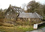 Upload another image | |
| Lorne Furnace | Bonawe | NN0097431882 | 56°26′13″N 5°13′47″W / 56.437012°N 5.22985°W / 56.437012; -5.22985 (Lorne Furnace) | 18th-century iron furnace[51] | 12180 |  Upload another image | |
| Kilarrow Parish Church | Main Street, Bowmore, Islay | NR3115959624 | 55°45′18″N 6°17′11″W / 55.755069°N 6.286429°W / 55.755069; -6.286429 (Kilarrow Parish Church) | Circular Georgian church of 1769[52] | 12184 | 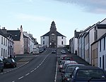 Upload another image | |
| Glenorchy Kirk (Clachan an Diseart) | Glenorchy | NN1676427516 | 56°24′15″N 4°58′16″W / 56.404238°N 4.971081°W / 56.404238; -4.971081 (Glenorchy Kirk (Clachan an Diseart)) | Early-19th-century Gothic church[53] | 12192 | 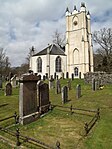 Upload another image | |
| Kilchurn Castle | On a promontory of Loch Awe | Not listed | NN1328727626 | 56°24′14″N 5°01′39″W / 56.403863°N 5.027419°W / 56.403863; -5.027419 (Kilchurn Castle) | 15th-century keep with 17th-century ranges[54] | 12194 |  Upload another image |
| Iona Abbey | Iona | NM2868324515 | 56°20′06″N 6°23′29″W / 56.335021°N 6.391433°W / 56.335021; -6.391433 (Iona Abbey) | Complex of buildings dating from the 12th century to c. 1500[55] | 12310 |  Upload another image | |
| Iona Nunnery | Iona | Not listed | NM2848724095 | 56°19′52″N 6°23′39″W / 56.331146°N 6.39416°W / 56.331146; -6.39416 (Iona Nunnery) | 12th-century church and convent[56] | 12317 |  Upload another image |
| Dhu Heartach Lighthouse | Dubh Artach, 15.5 miles (24.9 km) off Iona | NM1227003050 | 56°07′59″N 6°37′58″W / 56.133126°N 6.632725°W / 56.133126; -6.632725 (Dhu Heartach Lighthouse) | Granite lighthouse by David Stevenson, completed 1872[57] | 12320 |  Upload another image | |
| Castle Stalker | On an islet in Loch Laich, part of Loch Linnhe | NM9207847310 | 56°34′18″N 5°23′10″W / 56.571539°N 5.386192°W / 56.571539; -5.386192 (Castle Stalker) | 16th-century tower house[58] | 12345 |  Upload another image | |
| Lismore Lighthouse | Eilean Musdile, Lismore | NM7781235105 | 56°27′20″N 5°36′27″W / 56.455574°N 5.607487°W / 56.455574; -5.607487 (Lismore Lighthouse) | 1833 lighthouse by Robert Stevenson[59] | 12360 |  Upload another image | |
| Airds House | Port Appin | NM9094544982 | 56°33′01″N 5°24′10″W / 56.550158°N 5.402722°W / 56.550158; -5.402722 (Airds House) | 18th-century country house[60] | 12363 | 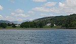 Upload another image | |
| Islandadd Bridge | Bellanoch | NR8048592479 | 56°04′29″N 5°31′44″W / 56.074595°N 5.528798°W / 56.074595; -5.528798 (Islandadd Bridge) | Cast-iron road bridge of 1851[61] | 13042 | 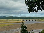 Upload another image | |
| Ardkinglas House | Loch Fyne | NN1751110384 | 56°15′03″N 4°56′50″W / 56.250814°N 4.947115°W / 56.250814; -4.947115 (Ardkinglas House) | 1908 country house by Robert Lorimer[62] | 13786 |  Upload another image | |
| Rossdhu House | Loch Lomond | NS3617989506 | 56°04′13″N 4°38′00″W / 56.070241°N 4.633319°W / 56.070241; -4.633319 (Rossdhu House) | 18th-century country house and walled garden[63] | 14469 |  Upload another image | |
| Hynish Harbour and Lighthouse Establishment | Hynish, Tiree | NL9852839183 | 56°26′53″N 6°53′39″W / 56.448103°N 6.894286°W / 56.448103; -6.894286 (Hynish Harbour and Lighthouse Establishment) | Mid-19th-century group, including signal tower, housing, stores, and enclosures[64] | 17848 |  Upload another image | |
| Skerryvore Lighthouse | Skerryvore, 11 miles (18 km) off Tiree | NL8383026290 | 56°19′23″N 7°06′58″W / 56.323117°N 7.11624°W / 56.323117; -7.11624 (Skerryvore Lighthouse) | 1844 lighthouse by Alan Stevenson[65] | 17849 | 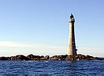 Upload another image | |
| 3 Kilmoluaig | Kilmoluaig, Tiree | NL9683845715 | 56°30′20″N 6°55′45″W / 56.505486°N 6.929189°W / 56.505486; -6.929189 (3 Kilmoluaig) | 19th-century thatched cottage[66] | 17857 | Upload Photo | |
| 13 Kilmoluaig | Kilmoluaig, Tiree | NL9711446089 | 56°30′32″N 6°55′31″W / 56.509012°N 6.925157°W / 56.509012; -6.925157 (13 Kilmoluaig) | 19th-century thatched cottage[67] | 17859 | Upload Photo | |
| Torosay Castle, statues In Statue Walk | Mull | NM7287735228 | 56°27′16″N 5°41′15″W / 56.454326°N 5.687499°W / 56.454326; -5.687499 (Torosay Castle, statues In Statue Walk) | 18th-century sculptures by Antonio Bonazza[68] | 17929 | 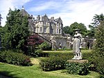 Upload another image | |
| Macquarrie Mausoleum | Gruline, Mull | NM5494139836 | 56°29′12″N 5°58′56″W / 56.486647°N 5.982139°W / 56.486647; -5.982139 (Macquarrie Mausoleum) | Gothic mausoleum, 1824, to Lachlan Macquarie, Governor of New South Wales[69] | 17942 |  Upload another image | |
| Duart Castle | Mull | NM7489335325 | 56°27′22″N 5°39′18″W / 56.456162°N 5.654941°W / 56.456162; -5.654941 (Duart Castle) | 14th-century tower with 17th-century house[70] | 17974 | 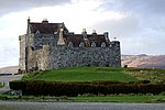 Upload another image | |
| Torosay Castle | Mull | NM7289635294 | 56°27′18″N 5°41′14″W / 56.454926°N 5.687249°W / 56.454926; -5.687249 (Torosay Castle) | 1856 mansion by David Bryce[71] | 17975 | 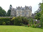 Upload another image | |
| Wester Kames Tower | Isle of Bute | NS0616968062 | 55°52′00″N 5°05′57″W / 55.866639°N 5.099252°W / 55.866639; -5.099252 (Wester Kames Tower) | Tower house rebuilt by Robert Weir Schultz 1897–1900[72] | 18287 |  Upload another image | |
| Stewart Hall | Isle of Bute | NS0552262757 | 55°49′08″N 5°06′21″W / 55.818783°N 5.105774°W / 55.818783; -5.105774 (Stewart Hall) | 18th-century Palladian house[73] | 18289 | Upload Photo | |
| Cour House | Saddell | NR8234248147 | 55°40′40″N 5°27′48″W / 55.677863°N 5.463404°W / 55.677863; -5.463404 (Cour House) | Country house of 1922 by Oliver Hill[74] | 18360 | Upload Photo | |
| Castle Sween | Knapdale | NR7123578829 | 55°56′52″N 5°39′56″W / 55.947873°N 5.665469°W / 55.947873; -5.665469 (Castle Sween) | Courtyard castle of c. 1200, the oldest stone castle surviving in Scotland[75] | 18389 |  Upload another image | |
| Saddell Castle | Saddell | NR7890631545 | 55°31′39″N 5°30′17″W / 55.527417°N 5.504622°W / 55.527417; -5.504622 (Saddell Castle) | Early-16th-century tower with later additions[76] | 18403 | 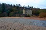 Upload another image | |
| Ardencaple Hotel | Rhu Road Lower, Rhu | NS2776583485 | 56°00′48″N 4°45′52″W / 56.013252°N 4.764446°W / 56.013252; -4.764446 (Ardencaple Hotel) | Early-19th-century posting inn[77] | 19525 |  Upload another image | |
| Rossdhu South Lodge and Gate | Rossdhu, Loch Lomond | NS3529986846 | 56°02′46″N 4°38′45″W / 56.046066°N 4.645803°W / 56.046066; -4.645803 (Rossdhu South Lodge and Gate) | 19th-century estate gateway[78] | 19698 | 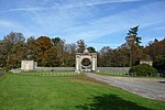 Upload another image | |
| Mull of Kintyre Lighthouse | Mull of Kintyre | NR5874008412 | 55°18′38″N 5°48′12″W / 55.310469°N 5.803365°W / 55.310469; -5.803365 (Mull of Kintyre Lighthouse) | 18th-century lighthouse, one of first four lighthouses built for the Commissioners of Northern Lighthouses[79] | 19874 |  Upload another image | |
| Bellgrove | High Askomil, Campbeltown | NR7297020892 | 55°25′45″N 5°35′23″W / 55.42916°N 5.589763°W / 55.42916; -5.589763 (Bellgrove) | Early-19th-century house of Palladian form[80] | 22940 | Upload Photo | |
| Rothmar | High Askomil, Campbeltown | NR7276620883 | 55°25′44″N 5°35′35″W / 55.428984°N 5.592973°W / 55.428984; -5.592973 (Rothmar) | Late-19th-century house by John James Burnet[81] | 22941 | Upload Photo | |
| Campbeltown Library and Museum | Hall Street, Campbeltown | NR7209920346 | 55°25′26″N 5°36′11″W / 55.423859°N 5.603052°W / 55.423859; -5.603052 (Campbeltown Library and Museum) | Late-19th-century Renaissance-style building by John James Burnet[82] | 22964 |  Upload another image | |
| St. John's Church of Scotland | Argyll Street, Dunoon | NS1720976939 | 55°57′02″N 4°55′45″W / 55.950606°N 4.929088°W / 55.950606; -4.929088 (St. John's Church of Scotland) | 19th-century Gothic revival church[83] | 26440 |  Upload another image | |
| Rockland | Clyde Street East, Helensburgh | NS3059681710 | 55°59′54″N 4°43′05″W / 55.998331°N 4.717971°W / 55.998331; -4.717971 (Rockland) | Greek revival villa by Alexander Thomson, 1854[84] | 34737 | Upload Photo | |
| The Hill House | Colquhoun Street Upper, Helensburgh | NS3005583817 | 56°01′01″N 4°43′41″W / 56.017049°N 4.727968°W / 56.017049; -4.727968 (The Hill House) | 1902 house by Charles Rennie Mackintosh, owned by the National Trust for Scotland[85] | 34761 | 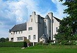 Upload another image | |
| The White House | Colquhoun Street Upper, Helensburgh | NS2988983609 | 56°00′54″N 4°43′50″W / 56.015124°N 4.730496°W / 56.015124; -4.730496 (The White House) | 1899 Arts and Crafts house by Baillie Scott[86] | 34762 |  Upload another image | |
| Drumadoon (formerly Morar Lodge) | Colquhoun Street Upper, Helensburgh | NS2996383861 | 56°01′03″N 4°43′46″W / 56.017411°N 4.72947°W / 56.017411; -4.72947 (Drumadoon (formerly Morar Lodge)) | 1903 house by William Leiper, now a private nursing home[87] | 34763 |  Upload another image | |
| Greycourt | Dhuhill Drive West, Helensburgh | NS2987983746 | 56°00′59″N 4°43′51″W / 56.01635°N 4.730743°W / 56.01635; -4.730743 (Greycourt) | 1911 Arts and Crafts villa by A N Paterson[88] | 34771 | Upload Photo | |
| Red Towers | Douglas Drive, Helensburgh | NS2997483575 | 56°00′53″N 4°43′45″W / 56.014849°N 4.729113°W / 56.014849; -4.729113 (Red Towers) | Renaissance-style house of 1898 by William Leiper[89] | 34774 |  Upload another image | |
| Brantwoode | Munro Drive West, Helensburgh | NS2992583365 | 56°00′47″N 4°43′47″W / 56.012947°N 4.729765°W / 56.012947; -4.729765 (Brantwoode) | 1895 Arts and Crafts house by William Leiper[90] | 34822 | 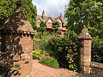 Upload another image | |
| Cairndhu House | Rhu Road Lower, Helensburgh | NS2843682705 | 56°00′23″N 4°45′12″W / 56.006493°N 4.753198°W / 56.006493; -4.753198 (Cairndhu House) | 1871 villa by William Leiper with Anglo-Japanese interior[91] | 34847 |  Upload another image | |
| Dalmore House | Rhu Road Lower, Helensburgh | NS2807683261 | 56°00′41″N 4°45′34″W / 56.011354°N 4.75932°W / 56.011354; -4.75932 (Dalmore House) | Baronial mansion of 1873 by William Leiper[92] | 34849 | 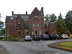 Upload another image | |
| Longcroft | Rossdhu Drive West, Helensburgh | NS2953583391 | 56°00′47″N 4°44′10″W / 56.013041°N 4.736029°W / 56.013041; -4.736029 (Longcroft) | 1902 Renaissance-style house by A N Paterson[93] | 34851 | Upload Photo | |
| Former Helensburgh and Gareloch Conservative Club | 38-40 Sinclair Street, Helensburgh | NS2967382333 | 56°00′13″N 4°43′59″W / 56.003595°N 4.733148°W / 56.003595; -4.733148 (Former Helensburgh and Gareloch Conservative Club) | Glasgow Style building by Honeyman and Keppie[94] | 34868 | 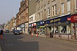 Upload another image | |
| War Memorial | Hermitage Park, Helensburgh | NS2999782840 | 56°00′30″N 4°43′42″W / 56.008261°N 4.728279°W / 56.008261; -4.728279 (War Memorial) | 1923 monument by A N Paterson, in walled garden[95] | 34872 |  Upload another image | |
| St Michael and All Angels' Episcopal Church | William Street, Helensburgh | NS2924282502 | 56°00′18″N 4°44′25″W / 56.004959°N 4.740158°W / 56.004959; -4.740158 (St Michael and All Angels' Episcopal Church) | 1868 church and later church hall by Robert Rowand Anderson[96] | 34896 |  Upload another image | |
| Inveraray Parish Church | Church Square, Inveraray | NN0958808429 | 56°13′49″N 5°04′24″W / 56.230166°N 5.073389°W / 56.230166; -5.073389 (Inveraray Parish Church) | 1805 church by Robert Mylne, housed separate Gaelic and English-speaking congregations[97] | 34978 |  Upload another image | |
| Morrison's Land | North Main Street West, Inveraray | NN0959408480 | 56°13′50″N 5°04′24″W / 56.230626°N 5.073329°W / 56.230626; -5.073329 (Morrison's Land) | Georgian houses of 1767[98] | 34981 |  Upload another image | |
| George Hotel | North Main Street East, Inveraray | NN0963008450 | 56°13′49″N 5°04′22″W / 56.230371°N 5.072728°W / 56.230371; -5.072728 (George Hotel) | Georgian hotel of 1779[99] | 34995 |  Upload another image | |
| Relief Land | South Main Street East, Inveraray | NN0957708367 | 56°13′47″N 5°04′25″W / 56.229605°N 5.073522°W / 56.229605; -5.073522 (Relief Land) | Georgian housing of 1779[100] | 34999 |  Upload another image | |
| Mackenzie's Land | South Main Street West, Inveraray | NN0952508338 | 56°13′46″N 5°04′28″W / 56.229324°N 5.074338°W / 56.229324; -5.074338 (Mackenzie's Land) | Georgian housing of 1775[101] | 35000 | Upload Photo | |
| Black's Land | South Main Street West, Inveraray | NN0953408353 | 56°13′46″N 5°04′27″W / 56.229462°N 5.074204°W / 56.229462; -5.074204 (Black's Land) | 18th-century housing[102] | 35001 | Upload Photo | |
| Arkland | South Main Street West, Inveraray | NN0955208379 | 56°13′47″N 5°04′26″W / 56.229703°N 5.073933°W / 56.229703; -5.073933 (Arkland) | Georgian housing of 1775 by Robert Mylne[103] | 35002 |  Upload another image | |
| Post Office, grocers shop and house | Front Street East, Inveraray | NN0969008527 | 56°13′52″N 5°04′19″W / 56.231086°N 5.071817°W / 56.231086; -5.071817 (Post Office, grocers shop and house) | Georgian housing and shop, 1776[104] | 35003 |  Upload another image | |
| Gillie's House (Buntain's) | Front Street East, Inveraray | NN0967908533 | 56°13′52″N 5°04′19″W / 56.231135°N 5.071998°W / 56.231135; -5.071998 (Gillie's House (Buntain's)) | Georgian housing and former bank, 1760[105] | 35004 | Upload another image | |
| Former Temperance Hotel | Front Street East, Inveraray | NN0967108539 | 56°13′52″N 5°04′20″W / 56.231186°N 5.072131°W / 56.231186; -5.072131 (Former Temperance Hotel) | Later 18th-century house[106] | 35005 | Upload another image | |
| Chamberlain's House | Front Street West, Inveraray | NN0964608553 | 56°13′53″N 5°04′21″W / 56.231302°N 5.072544°W / 56.231302; -5.072544 (Chamberlain's House) | Georgian house of 1751 by John Adam[107] | 35006 |  Upload another image | |
| Town House | Front Street West, Inveraray | NN0962708563 | 56°13′53″N 5°04′22″W / 56.231384°N 5.072857°W / 56.231384; -5.072857 (Town House) | Customs house, court house and prison by John Adam, 1755[108] | 35007 | Upload another image | |
| Ivy House | Front Street West, Inveraray | NN0961708567 | 56°13′53″N 5°04′23″W / 56.231415°N 5.073021°W / 56.231415; -5.073021 (Ivy House) | Georgian house of c. 1755 by John Adam[109] | 35008 | Upload another image | |
| The Avenue Screen Wall | Front Street West, Inveraray | NN0959608582 | 56°13′54″N 5°04′24″W / 56.231542°N 5.07337°W / 56.231542; -5.07337 (The Avenue Screen Wall) | Arched wall of 1788 by Robert Mylne[110] | 35009 |  Upload another image | |
| The Great Inn (Argyll Arms Hotel) | Front Street West, Inveraray | NN0955408601 | 56°13′54″N 5°04′27″W / 56.231695°N 5.07406°W / 56.231695; -5.07406 (The Great Inn (Argyll Arms Hotel)) | Georgian inn of 1757[111] | 35011 | 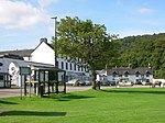 Upload another image | |
| Dalmally Road Screen Wall | Front Street West, Inveraray | NN0954708609 | 56°13′54″N 5°04′27″W / 56.231764°N 5.074179°W / 56.231764; -5.074179 (Dalmally Road Screen Wall) | Arched wall of 1790 by Robert Mylne[112] | 35013 |  Upload another image | |
| The Duke's Tower (Belfry), beside All Saints Church. | Inveraray | NN0946608453 | 56°13′49″N 5°04′31″W / 56.230332°N 5.075371°W / 56.230332; -5.075371 (The Duke's Tower (Belfry), beside All Saints Church.) | Gothic revival bell tower, completed 1932[113] | 35019 |  Upload another image | |
| Inveraray Court House | Crown Point, Inveraray | NN0965108394 | 56°13′48″N 5°04′20″W / 56.229877°N 5.072349°W / 56.229877; -5.072349 (Inveraray Court House) | Georgian court house and prison by James Gillespie Graham, 1819, now a museum[114] | 35030 |  Upload another image | |
| Prison Wall | Crown Point, Inveraray | NN0967608381 | 56°13′47″N 5°04′19″W / 56.22977°N 5.071937°W / 56.22977; -5.071937 (Prison Wall) | Substantial wall around former court house, also by James Gillespie Graham[115] | 35032 |  Upload another image | |
| Factory Land | Inveraray | NN0967208418 | 56°13′48″N 5°04′19″W / 56.230101°N 5.072028°W / 56.230101; -5.072028 (Factory Land) | Late-18th-century housing[116] | 35037 | Upload Photo | |
| Ferry Land | Inveraray | NN0968308438 | 56°13′49″N 5°04′19″W / 56.230285°N 5.071865°W / 56.230285; -5.071865 (Ferry Land) | Late-18th-century housing[117] | 35038 | Upload Photo | |
| Fern Point (Ardrainic) | Inveraray | NN0967608460 | 56°13′50″N 5°04′19″W / 56.230479°N 5.071994°W / 56.230479; -5.071994 (Fern Point (Ardrainic)) | Georgian house of 1753, the earliest house in the new town of Inveraray[118] | 35039 | Upload Photo | |
| St. Columba's Cathedral | Corran Esplanade, Oban | NM8553230679 | 56°25′10″N 5°28′44″W / 56.419458°N 5.478834°W / 56.419458; -5.478834 (St. Columba's Cathedral) | Modern Gothic church by Sir Giles Gilbert Scott, completed 1952[119] | 38820 | 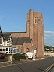 Upload another image | |
| Bute Mausoleum | High Kirk of Rothesay, Rothesay, Bute | NS0857963723 | 55°49′43″N 5°03′28″W / 55.828672°N 5.057738°W / 55.828672; -5.057738 (Bute Mausoleum) | Late-18th-century mausoleum of eclectic design[120] | 40446 |  Upload another image | |
| St Andrew's Roman Catholic Church | Columshill Street, Rothesay, Bute | NS0857564566 | 55°50′10″N 5°03′30″W / 55.836234°N 5.058396°W / 55.836234; -5.058396 (St Andrew's Roman Catholic Church) | Byzantine-style church of 1923 by Reginald Fairlie[121] | 40451 | Upload Photo | |
| Rothesay Pavilion | Argyle Street, Rothesay, Bute | NS0837265068 | 55°50′26″N 5°03′43″W / 55.840657°N 5.061987°W / 55.840657; -5.061987 (Rothesay Pavilion) | International Style entertainment pavilion of 1938, by James Carrick[122] | 40452 |  Upload another image | |
| The Winter Gardens | Victoria Street, Rothesay, Bute | NS0875564794 | 55°50′18″N 5°03′20″W / 55.838351°N 5.055687°W / 55.838351; -5.055687 (The Winter Gardens) | Domed winter garden and bandstand of 1923, with Art Nouveau detailing[123] | 40454 |  Upload another image | |
| Bute Estate Office | 55 High Street, Rothesay, Bute | NS0884964526 | 55°50′10″N 5°03′14″W / 55.835984°N 5.054°W / 55.835984; -5.054 (Bute Estate Office) | 17th-century building, originally the Marquess of Bute's town house [124] | 40456 | 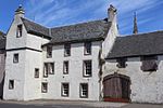 Upload another image | |
| Tor House | Ardencraig Road, Rothesay, Bute | NS1056365012 | 55°50′28″N 5°01′37″W / 55.84102°N 5.027012°W / 55.84102; -5.027012 (Tor House) | Greek-revival villa by Alexander Thomson, c. 1855[125] | 40468 | Upload Photo | |
| Gareloch House | Clynder, Gareloch | NS2501483696 | 56°00′51″N 4°48′31″W / 56.014149°N 4.808653°W / 56.014149; -4.808653 (Gareloch House) | Early-19th-century classical villa with particularly fine landscaped garden[126] | 42621 | Upload Photo | |
| Bathwell | Rosneath Castle Estate, Rosneath | NS2640881940 | 55°59′56″N 4°47′07″W / 55.998898°N 4.785186°W / 55.998898; -4.785186 (Bathwell) | Mid-later 18th-century bath house[127] | 42625 | Upload Photo | |
| Rosneath Home Farm | Rosneath Castle Estate, Rosneath | NS2656481414 | 55°59′39″N 4°46′56″W / 55.994234°N 4.782349°W / 55.994234; -4.782349 (Rosneath Home Farm) | Large Gothic steading by Alexander Nasmyth, 1803[128] | 42628 | 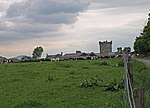 Upload another image | |
| Ferry Inn | Rosneath Point, Rosneath | NS2578283415 | 56°00′43″N 4°47′46″W / 56.011907°N 4.796168°W / 56.011907; -4.796168 (Ferry Inn) | 1897 Arts and Crafts villa by Edwin Lutyens[129] | 42630 | Upload Photo | |
| St Modan's Parish Church | Rosneath | NS2544183157 | 56°00′34″N 4°48′05″W / 56.009468°N 4.801462°W / 56.009468; -4.801462 (St Modan's Parish Church) | 1854 English Gothic church by David Cousin[130] | 42634 | 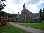 Upload another image | |
| Saint Mahew's Chapel | Darleith Road, Cardross | NS3420878639 | 55°58′19″N 4°39′30″W / 55.972031°N 4.658231°W / 55.972031; -4.658231 (Saint Mahew's Chapel) | 15th-century chapel, restored in the 1950s as a Catholic church[131] | 42905 | 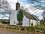 Upload another image | |
| Redholme | Kilkerran Road, Campbeltown | NR7239919842 | 55°25′10″N 5°35′52″W / 55.419479°N 5.597911°W / 55.419479; -5.597911 (Redholme) | Arts and Crafts villa of 1896 by Henry E Clifford[132] | 43088 | Upload Photo | |
| Sloy Power Station | Loch Sloy | NN2887111074 | 56°15′40″N 4°45′52″W / 56.261234°N 4.76445°W / 56.261234; -4.76445 (Sloy Power Station) | Designed in a classical style by Tarbolton & Ochterlony, with buttress-type dam by James Williamson, opened 1950[133] | 43188 | 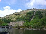 Upload another image | |
| The Dolls' Houses | Killean House Estate, Kintyre | NR6958044657 | 55°38′26″N 5°39′47″W / 55.64068°N 5.663002°W / 55.64068; -5.663002 (The Dolls' Houses) | Pair of arts and crafts cottages by John James Burnet[134] | 43266 | 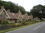 Upload another image | |
| Glen Eden | Shore Road, Kilcreggan | NS2233281021 | 55°59′21″N 4°50′59″W / 55.989158°N 4.849849°W / 55.989158; -4.849849 (Glen Eden) | 1850s villa by Alexander Thomson[135] | 43442 | Upload Photo | |
| Knockderry Castle | Shore Road, Cove | NS2168083405 | 56°00′37″N 4°51′43″W / 56.010309°N 4.861869°W / 56.010309; -4.861869 (Knockderry Castle) | 1850s house by Alexander Thomson, with Baronial additions by William Leiper, 1897[136] | 43452 |  Upload another image | |
| Craig Ailey | South Ailey Road, Cove | NS2221381361 | 55°59′32″N 4°51′07″W / 55.992165°N 4.851979°W / 55.992165; -4.851979 (Craig Ailey) | 1850 villa by Alexander Thomson[137] | 43472 |  Upload another image | |
| Auchendennan House | Arden | NS3683783495 | 56°00′59″N 4°37′09″W / 56.016516°N 4.619101°W / 56.016516; -4.619101 (Auchendennan House) | Baronial chateau by John Burnet, 1866[138] | 43871 | 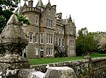 Upload another image | |
| Darleith Dovecot | Darleith House, Colgrain | NS3464880583 | 55°59′23″N 4°39′09″W / 55.989631°N 4.652384°W / 55.989631; -4.652384 (Darleith Dovecot) | Late-18th-century 4-stage dovecot[139] | 43874 | 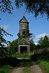 Upload another image | |
| Rothesay Castle | Rothesay, Bute | Not listed | NS0878964577 | 55°50′11″N 5°03′18″W / 55.836417°N 5.054992°W / 55.836417; -5.054992 (Rothesay Castle) | 13th-century castle, rebuilt c. 1500 and restored c. 1900 by the Marquess of Bute[140] | 44887 |  Upload another image |
| Balmory House | Balmory Road, Ascog, Bute | NS1038762820 | 55°49′17″N 5°01′42″W / 55.821284°N 5.028288°W / 55.821284; -5.028288 (Balmory House) | 1861 Italianate villa with Adam Style interiors[141] | 44984 | Upload Photo | |
| Former Charcoal Store | Ironworks, Furnace, Argyll and Bute | NN0260500099 | 56°09′09″N 5°10′47″W / 56.152594°N 5.179656°W / 56.152594; -5.179656 (Former Charcoal Store) | Mid 18th-century rubble-built industrial building, later used as a drill hall[142] | 49844 | Upload Photo | |
| Falls of Cruachan Railway Viaduct | Ardchattan And Muckairn | 1 February 2007 | NN0788326824 | 56°23′40″N 5°06′51″W / 56.3945°N 5.1142°W / 56.3945; -5.1142 (Falls of Cruachan Railway Viaduct) | 3-arch, part-concrete railway viaduct designed by John Strain, 1880 | 50811 | 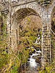 Upload another image |
| Ben Cruachan Hydro Electric Scheme, Turbine Hall | Ben Cruachan, Argyll and Bute | 11 February 2011 | NN0801428152 | 56°24′23″N 5°06′47″W / 56.406389°N 5.113056°W / 56.406389; -5.113056 (Ben Cruachan Hydro Electric Scheme, Turbine Hall) | J B Armstrong, 1959-65 | 51688 | Upload Photo |
See also
Notes
- ^ Sometimes known as OSGB36, the grid reference (where provided) is based on the British national grid reference system used by the Ordnance Survey.
• "Guide to National Grid". Ordnance Survey. Retrieved 12 December 2007.
• "Get-a-map". Ordnance Survey. Retrieved 17 December 2007. - ^ Historic Environment Scotland assign a unique alphanumeric identifier to each designated site in Scotland, for listed buildings this always begins with "LB", for example "LB12345".
References
- ^ Guide to the Protection of Scotland's Listed Buildings (PDF). Historic Scotland. 2009. p. 4. ISBN 978-1-84917-013-0. Retrieved 5 May 2010.
- ^ "What is Listing?". Historic Scotland. Retrieved 5 May 2010.
- ^ a b Scottish Historic Environment Policy (PDF). Historic Scotland. October 2008. pp. 24–25. ISBN 978-1-84917-002-4. Retrieved 5 May 2010.
- ^ Guide to the Protection of Scotland’s Listed Buildings, p. 17.
- ^ "Listed Buildings" (PDF). Argyll and Bute Council. Retrieved 7 September 2010.
- ^ "St. Conan's Church, Listed Building Report". Historic Scotland. Retrieved 18 May 2010.
- ^ "Old Breacacha Castle, Listed Building Report". Historic Scotland. Retrieved 18 May 2010.
- ^ "Breacacha Castle, Listed Building Report". Historic Scotland. Retrieved 4 December 2011.
- ^ "Lochnell House, Listed Building Report". Historic Scotland. Retrieved 18 May 2010.
- ^ "Lochnell Observatory, Listed Building Report". Historic Scotland. Retrieved 18 May 2010.
- ^ "Barcaldine Castle, Listed Building Report". Historic Scotland. Retrieved 18 May 2010.
- ^ "Barbreck House, Listed Building Report". Historic Scotland. Retrieved 18 May 2010.
- ^ "St Munn's Parish Church, Listed Building Report". Historic Scotland. Retrieved 18 May 2010.
- ^ "Dunselma, Listed Building Report". Historic Scotland. Retrieved 18 May 2010.
- ^ "Oronsay Priory, Listed Building Report". Historic Scotland. Retrieved 18 May 2010.
- ^ "Oronsay Great Cross, Listed Building Report". Historic Scotland. Retrieved 18 May 2010.
- ^ "Golden Gates, Benmore Botanic Garden, Listed Building Report". Historic Scotland. Retrieved 18 May 2010.
- ^ "St Peter's College, Listed Building Report". Historic Scotland. Retrieved 18 May 2010.
- ^ "Old Kilmun House, Listed Building Report". Historic Scotland. Retrieved 18 May 2010.
- ^ "Auchindrain Township, Listed Building Report". Historic Scotland. Retrieved 18 May 2010.
- ^ "Carnassarie Castle, Listed Building Report". Historic Scotland. Retrieved 18 May 2010.
- ^ "Maam Steading, Listed Building Report". Historic Scotland. Retrieved 18 May 2010.
- ^ "Cherrypark, Listed Building Report". Historic Scotland. Retrieved 18 May 2010.
- ^ "Carloon, Doocot, Listed Building Report". Historic Scotland. Retrieved 18 May 2010.
- ^ "Watch Tower, Listed Building Report". Historic Scotland. Retrieved 18 May 2010.
- ^ "Garden Bridge, Listed Building Report". Historic Scotland. Retrieved 18 May 2010.
- ^ "Aray Bridge, Listed Building Report". Historic Scotland. Retrieved 18 May 2010.
- ^ "Garron Lodge, Listed Building Report". Historic Scotland. Retrieved 18 May 2010.
- ^ "Garron Screen Wall, Listed Building Report". Historic Scotland. Retrieved 18 May 2010.
- ^ "Garron Bridge, Listed Building Report". Historic Scotland. Retrieved 18 May 2010.
- ^ "Dubh Loch Bridge, Listed Building Report". Historic Scotland. Retrieved 18 May 2010.
- ^ "Inveraray Castle, Listed Building Report". Historic Scotland. Retrieved 18 May 2010.
- ^ "St. Columba's Monastery, Listed Building Report". Historic Scotland. Retrieved 18 May 2010.
- ^ "Dunderave Castle, Listed Building Report". Historic Scotland. Retrieved 18 May 2010.
- ^ "Dunans Bridge, Listed Building Report". Historic Scotland. Retrieved 18 May 2010.
- ^ "Sun-Dial At Ormidale House, Listed Building Report". Historic Scotland. Retrieved 18 May 2010.
- ^ "Carrick Castle, Listed Building Report". Historic Scotland. Retrieved 18 May 2010.
- ^ "Kilmorich Kirk, Listed Building Report". Historic Scotland. Retrieved 18 May 2010.
- ^ "Clachan Bridge, Listed Building Report". Historic Scotland. Retrieved 18 May 2010.
- ^ "Rhinns Of Islay Lighthouse, Listed Building Report". Historic Scotland. Retrieved 18 May 2010.
- ^ "Dunstaffnage Castle, Listed Building Report". Historic Scotland. Retrieved 18 May 2010.
- ^ "Dunstaffnage Chapel, Listed Building Report". Historic Scotland. Retrieved 18 May 2010.
- ^ "Killean Chapel (St John's) Killean Burial Ground., Listed Building Report". Historic Scotland. Retrieved 18 May 2010.
- ^ "Killean House, Listed Building Report". Historic Scotland. Retrieved 18 May 2010.
- ^ "Killean And Kilchenzie Kirk A'chleit, Listed Building Report". Historic Scotland. Retrieved 18 May 2010.
- ^ "Mount Stuart House, Listed Building Report". Historic Scotland. Retrieved 18 May 2010.
- ^ "Mount Stuart, Mausoleum And Graveyard, Listed Building Report". Historic Scotland. Retrieved 18 May 2010.
- ^ "Mount Stuart, Kerrylamont Farm Dairy, Listed Building Report". Historic Scotland. Retrieved 18 May 2010.
- ^ "Islay House, Listed Building Report". Historic Scotland. Retrieved 18 May 2010.
- ^ "Islay Woollen Mill And Bridge, Listed Building Report". Historic Scotland. Retrieved 18 May 2010.
- ^ "Lorne Furnace And Ancillary Buildings, Bonawe, Listed Building Report". Historic Scotland. Retrieved 18 May 2010.
- ^ "Kilarrow Parish Church, Main Street, Listed Building Report". Historic Scotland. Retrieved 18 May 2010.
- ^ "Glenorchy Kirk Clachan An Diseart, Listed Building Report". Historic Scotland. Retrieved 18 May 2010.
- ^ "Kilchurn Castle, Listed Building Report". Historic Scotland. Retrieved 18 May 2010.
- ^ "Iona Abbey, Listed Building Report". Historic Scotland. Retrieved 18 May 2010.
- ^ "Iona Nunnery, Listed Building Report". Historic Scotland. Retrieved 18 May 2010.
- ^ "Dhu Heartach Lighthouse, Listed Building Report". Historic Scotland. Retrieved 18 May 2010.
- ^ "Castle Stalker, Listed Building Report". Historic Scotland. Retrieved 18 May 2010.
- ^ "Lismore Lighthouse Eilean Musdile, Listed Building Report". Historic Scotland. Retrieved 18 May 2010.
- ^ "Airds House, Listed Building Report". Historic Scotland. Retrieved 18 May 2010.
- ^ "Islandadd Bridge, Listed Building Report". Historic Scotland. Retrieved 18 May 2010.
- ^ "Ardkinglas House, Listed Building Report". Historic Scotland. Retrieved 18 May 2010.
- ^ "Rossdhu House With Walled Garden, Listed Building Report". Historic Scotland. Retrieved 18 May 2010.
- ^ "Hynish, Harbour And Lighthouse Establishment, Including Signal Tower, Housing, Sheds/Stores, Dam And Walled Enclosures, Listed Building Report". Historic Scotland. Retrieved 18 May 2010.
- ^ "Skerryvore Lighthouse, Listed Building Report". Historic Scotland. Retrieved 18 May 2010.
- ^ "3 Kilmoluaig, Listed Building Report". Historic Scotland. Retrieved 18 May 2010.
- ^ "13 Kilmoluaig, Listed Building Report". Historic Scotland. Retrieved 18 May 2010.
- ^ "Torosay Castle Statues In Statue Walk, Listed Building Report". Historic Scotland. Retrieved 18 May 2010.
- ^ "Macquarrie Mausoleum Gruline Policies, Listed Building Report". Historic Scotland. Retrieved 18 May 2010.
- ^ "Duart Castle, Listed Building Report". Historic Scotland. Retrieved 18 May 2010.
- ^ "Torosay Castle, Listed Building Report". Historic Scotland. Retrieved 18 May 2010.
- ^ "Wester Kames Tower Including Boundary Fence, Listed Building Report". Historic Scotland. Retrieved 18 May 2010.
- ^ "Stewart Hall Including Conservatory, Well, Boundary Wall And Gatepiers, Listed Building Report". Historic Scotland. Retrieved 18 May 2010.
- ^ "Cour House Saddell, Listed Building Report". Historic Scotland. Retrieved 18 May 2010.
- ^ "Castle Sween, East Shore Of Loch Sween, Listed Building Report". Historic Scotland. Retrieved 18 May 2010.
- ^ "Saddell Castle, Listed Building Report". Historic Scotland. Retrieved 18 May 2010.
- ^ "Rhu Village, Rhu Road Lower, Ardencaple Hotel With Former Stables, Cottage Outbuildings And Boundary Wall, Listed Building Report". Historic Scotland. Retrieved 18 May 2010.
- ^ "Rossdhu Estate, South Lodge And Gate With Railings, Listed Building Report". Historic Scotland. Retrieved 18 May 2010.
- ^ "Mull Of Kintyre Lighthouse, Listed Building Report". Historic Scotland. Retrieved 18 May 2010.
- ^ "High Askomil, Bellgrove, With Stable, Laundry, Outbuildings, Boundary Walls, Gates, And Gatepiers, Listed Building Report". Historic Scotland. Retrieved 18 May 2010.
- ^ "High Askomil, Rothmar, With Garage, Terrace, Boundary And Retaining Walls, Gates And Gatepiers, Listed Building Report". Historic Scotland. Retrieved 18 May 2010.
- ^ "St John Street And Hall Street, Public Library And Museum, With Librarian's House, Garden, Railings, Gates, And Gatepiers, Listed Building Report". Historic Scotland. Retrieved 18 May 2010.
- ^ "St. John's Church Of Scotland. Hanover Street And Argyll Street, Listed Building Report". Historic Scotland. Retrieved 18 May 2010.
- ^ "150 Clyde Street East, Rockland And Sundial, Listed Building Report". Historic Scotland. Retrieved 18 May 2010.
- ^ "8 Colquhoun Street Upper, The Hill House With Outbuildings, Boundary Walls And Gates, Listed Building Report". Historic Scotland. Retrieved 18 May 2010.
- ^ "15 Colquhoun Street Upper, The White House With Garage And Boundary Wall, Listed Building Report". Historic Scotland. Retrieved 18 May 2010.
- ^ "17 Colquhoun Street Upper, Drumadoon (Formerly Morar Lodge) With Gatepiers And Boundary Wall And Garden Pavilion, Listed Building Report". Historic Scotland. Retrieved 18 May 2010.
- ^ "Dhuhill Drive West, Greycourt, Listed Building Report". Historic Scotland. Retrieved 18 May 2010.
- ^ "Douglas Drive, Red Towers With Boundary Wall, Gatepiers, Gates And Wellhead, Listed Building Report". Historic Scotland. Retrieved 18 May 2010.
- ^ "4 Munro Drive West, Brantwoode With Boundary Wall, Gatepiers, Garage And Garden Gate, Listed Building Report". Historic Scotland. Retrieved 18 May 2010.
- ^ "Rhu Road Lower, Cairndhu House, Listed Building Report". Historic Scotland. Retrieved 18 May 2010.
- ^ "Rhu Road Lower, Dalmore House, Listed Building Report". Historic Scotland. Retrieved 18 May 2010.
- ^ "Rossdhu Drive West, Longcroft, Listed Building Report". Historic Scotland. Retrieved 18 May 2010.
- ^ "38-40 Sinclair Street, Former Helensburgh And Gareloch Conservative Club, Listed Building Report". Historic Scotland. Retrieved 18 May 2010.
- ^ "Sinclair Street, Hermitage Park, War Memorial And Walled Garden With Ornamental Gates, Listed Building Report". Historic Scotland. Retrieved 18 May 2010.
- ^ "William Street, St Michael And All Angels' Episcopal Church And Church Hall, Listed Building Report". Historic Scotland. Retrieved 18 May 2010.
- ^ "Glenaray And Inveraray Parish Church And Church Hall, Church Square, Listed Building Report". Historic Scotland. Retrieved 18 May 2010.
- ^ "Morrison's Land, N. Main St. W. And Close At Rear., Listed Building Report". Historic Scotland. Retrieved 18 May 2010.
- ^ "George Hotel, N. Main Street E., Listed Building Report". Historic Scotland. Retrieved 18 May 2010.
- ^ "Relief Land, 86 Main St. East, Listed Building Report". Historic Scotland. Retrieved 18 May 2010.
- ^ "Mackenzie's Land, South Main Street West, Listed Building Report". Historic Scotland. Retrieved 18 May 2010.
- ^ "Black's Land; S. Main St. West, Listed Building Report". Historic Scotland. Retrieved 18 May 2010.
- ^ "Arkland, S. Main St. West, Listed Building Report". Historic Scotland. Retrieved 18 May 2010.
- ^ "Post Office, Grocers Shop And House East Front Street, Listed Building Report". Historic Scotland. Retrieved 18 May 2010.
- ^ "House (Buntain's) East Front Street., Listed Building Report". Historic Scotland. Retrieved 18 May 2010.
- ^ "House (Miss Maclacklands) Formerly Temperance Hotel E. Front St. And N. Main St. W., Listed Building Report". Historic Scotland. Retrieved 18 May 2010.
- ^ "Chamberlain's House, West Front Street And N. Main St. W., Listed Building Report". Historic Scotland. Retrieved 18 May 2010.
- ^ "Town House, W. Front St., Listed Building Report". Historic Scotland. Retrieved 18 May 2010.
- ^ "'Ivy House' W. Front St., Listed Building Report". Historic Scotland. Retrieved 18 May 2010.
- ^ "The Avenue Screen Wall, W. Front St., Listed Building Report". Historic Scotland. Retrieved 18 May 2010.
- ^ "West Front Street And Dalmally Road, The Great Inn, Listed Building Report". Historic Scotland. Retrieved 18 May 2010.
- ^ "Dalmally Road Screen Wall, W. Front St, Listed Building Report". Historic Scotland. Retrieved 18 May 2010.
- ^ "The Duke's Tower, (Belfry) Beside All Saints Church, Listed Building Report". Historic Scotland. Retrieved 18 May 2010.
- ^ "Inveraray Court House, Crown Point., Listed Building Report". Historic Scotland. Retrieved 18 May 2010.
- ^ "Prison Wall, Crown Point., Listed Building Report". Historic Scotland. Retrieved 18 May 2010.
- ^ "Factory Land, Listed Building Report". Historic Scotland. Retrieved 18 May 2010.
- ^ "Ferry Land, Listed Building Report". Historic Scotland. Retrieved 18 May 2010.
- ^ "'Fern Point' ('Ardrainich'), Listed Building Report". Historic Scotland. Retrieved 18 May 2010.
- ^ "Corran Esplanade, Cathedral Church Of St Columba, With Boundary Walls (Roman Catholic), Listed Building Report". Historic Scotland. Retrieved 18 May 2010.
- ^ "High Kirk Of Rothesay, Bute Mausoleum, Listed Building Report". Historic Scotland. Retrieved 18 May 2010.
- ^ "Columshill Street, St Andrew's Roman Catholic Church, Including Priest's House, Boundary Wall And Piers, Listed Building Report". Historic Scotland. Retrieved 18 May 2010.
- ^ "Argyle Street, Rothesay Pavilion Including House At Rear And Boundary Wall, Listed Building Report". Historic Scotland. Retrieved 18 May 2010.
- ^ "Victoria Street, The Winter Gardens, Listed Building Report". Historic Scotland. Retrieved 18 May 2010.
- ^ "55, 57 And 59 High Street Bute Estate Office Including Outbuilding, Listed Building Report". Historic Scotland. Retrieved 18 May 2010.
- ^ "Ardencraig Road, Tor House, Including Boundary Wall, Gatepiers And Gates, Listed Building Report". Historic Scotland. Retrieved 18 May 2010.
- ^ "Gareloch House With Retaining And Boundary Walls And Gatepiers, Listed Building Report". Historic Scotland. Retrieved 18 May 2010.
- ^ "Rosneath Castle Estate, Bathwell (Near Parkhead), Listed Building Report". Historic Scotland. Retrieved 18 May 2010.
- ^ "Rosneath Castle Estate, Rosneath Home Farm, Listed Building Report". Historic Scotland. Retrieved 18 May 2010.
- ^ "Rosneath Point, Ferry Inn, Listed Building Report". Historic Scotland. Retrieved 18 May 2010.
- ^ "Rosneath Village, St Modan's Parish Church, Listed Building Report". Historic Scotland. Retrieved 18 May 2010.
- ^ "Cardross, Darleith Road, Saint Mahew's Chapel, Listed Building Report". Historic Scotland. Retrieved 18 May 2010.
- ^ "Kilkerran Road, Redholme, With Outbuilding, Boundary Walls, Gates And Gatepiers, Listed Building Report". Historic Scotland. Retrieved 18 May 2010.
- ^ "Sloy Power Station Including Dam, Valve House, Feeder Pipes, Gates, Gatepiers And Boundary Wall, Listed Building Report". Historic Scotland. Retrieved 18 May 2010.
- ^ "Killean, The Dolls' Houses, Listed Building Report". Historic Scotland. Retrieved 18 May 2010.
- ^ "Shore Road, Glen Eden With Coach House, Gatepiers, Boundary Wall And Mile Sign, Listed Building Report". Historic Scotland. Retrieved 18 May 2010.
- ^ "Shore Road, Knockderry Castle With Boundary Walls, Gatepiers And Railings, Listed Building Report". Historic Scotland. Retrieved 18 May 2010.
- ^ "South Ailey Road, Craig Ailey With Boundary Wall, Gates And Gatepiers, Listed Building Report". Historic Scotland. Retrieved 18 May 2010.
- ^ "Auchendennan House With Conservatory, Terrace Wall, Fountain, Statury, Listed Building Report". Historic Scotland. Retrieved 18 May 2010.
- ^ "Darleith Dovecot, Listed Building Report". Historic Scotland. Retrieved 18 May 2010.
- ^ "Rothesay Castle And Chapel, Listed Building Report". Historic Scotland. Retrieved 18 May 2010.
- ^ "Ascog, Balmory Road, Balmory House (Former Laidlaw Memorial Home) Including Boundary Walls And Gatepiers, Listed Building Report". Historic Scotland. Retrieved 18 May 2010.
- ^ "Furnace Village, Former Charcoal Store, Listed Building Report". Historic Scotland. Retrieved 18 May 2010.
External links
![]() Media related to Category A listed buildings in Argyll and Bute at Wikimedia Commons
Media related to Category A listed buildings in Argyll and Bute at Wikimedia Commons
- v
- t
- e
- City of Aberdeen
- Aberdeenshire
- Angus
- Argyll and Bute
- Clackmannanshire
- Dumfries and Galloway
- City of Dundee
- East Ayrshire
- East Dunbartonshire
- East Lothian
- East Renfrewshire
- City of Edinburgh
- Falkirk
- Fife
- City of Glasgow
- Highland
- Inverclyde
- Midlothian
- Moray
- North Ayrshire
- North Lanarkshire
- Orkney
- Perth and Kinross
- Renfrewshire
- Scottish Borders
- Shetland
- South Ayrshire
- South Lanarkshire
- Stirling
- West Dunbartonshire
- West Lothian
- Western Isles (na h-Eileanan Siar)


