List of Category A listed buildings in East Dunbartonshire

Map all coordinates using OpenStreetMap
Download coordinates as:
- KML
- GPX (all coordinates)
- GPX (primary coordinates)
- GPX (secondary coordinates)
This is a list of Category A listed buildings in East Dunbartonshire, Scotland.
In Scotland, the term listed building refers to a building or other structure officially designated as being of "special architectural or historic interest".[1] Category A structures are those considered to be "buildings of national or international importance, either architectural or historic, or fine little-altered examples of some particular period, style or building type."[2] Listing was begun by a provision in the Town and Country Planning (Scotland) Act 1947, and the current legislative basis for listing is the Planning (Listed Buildings and Conservation Areas) (Scotland) Act 1997.[3] The authority for listing rests with Historic Scotland, an executive agency of the Scottish Government, which inherited this role from the Scottish Development Department in 1991. Once listed, severe restrictions are imposed on the modifications allowed to a building's structure or its fittings. Listed building consent must be obtained from local authorities prior to any alteration to such a structure.[3] There are approximately 47,400 listed buildings in Scotland, of which around 8% (some 3,800) are Category A.[4]
The council area of East Dunbartonshire covers 175 square kilometres (68 sq mi), and has a population of around 104,700. There are 15 Category A listed buildings in the area. These include several works by the Glasgow-based architect David Hamilton, including the now-derelict Lennox Castle, and two late villas by Alexander Thomson. There are several Category A listed churches and country houses, with the oldest being Bardowie Castle, which dates partly to the 16th century.
Listed buildings
| Name | Location | Date Listed | Grid Ref. [note 1] | Geo-coordinates | Notes | LB Number [note 2] | Image |
|---|---|---|---|---|---|---|---|
| High Church of Campsie | Main Street, Lennoxtown | 5/9/1973 | NS6282478012 | 55°58′32″N 4°11′59″W / 55.975435°N 4.199788°W / 55.975435; -4.199788 (High Church of Campsie) | 19th-century church by David Hamilton | 4353 |  Upload another image |
| Lennox Castle | Lennoxtown | 5/9/1973 | NS6058578301 | 55°58′39″N 4°14′09″W / 55.977384°N 4.235787°W / 55.977384; -4.235787 (Lennox Castle) | 19th-century country house by David Hamilton, later a hospital and now derelict | 4354 |  Upload another image |
| Kincaid House | Milton of Campsie | 5/9/1973 | NS6499076023 | 55°57′29″N 4°09′51″W / 55.958191°N 4.164109°W / 55.958191; -4.164109 (Kincaid House) | 17th-century country house, rebuilt in the 19th century by David Hamilton | 4357 |  Upload Photo |
| 27 Victoria Road | Lenzie | 17/8/1977 | NS6549271508 | 55°55′04″N 4°09′14″W / 55.917795°N 4.153823°W / 55.917795; -4.153823 (27 Victoria Road) | 19th-century villa by Alexander Thomson | 4407 | Upload Photo |
| Warwick Croft and 43 Alexandra Road | Heriot Road, Lenzie | 17/8/1977 | NS6537171488 | 55°55′03″N 4°09′21″W / 55.917581°N 4.155748°W / 55.917581; -4.155748 (Warwick Croft and 43 Alexandra Road) | Pair of 19th-century villas by Alexander Thomson | 4408 |  Upload another image |
| Bardowie Castle | Bardowie | 5/9/1973 | NS5781973720 | 55°56′08″N 4°16′40″W / 55.935446°N 4.277657°W / 55.935446; -4.277657 (Bardowie Castle) | 16th-century tower with later additions, still occupied | 5726 | 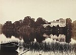 Upload another image |
| Mugdock Reservoir and Craigmaddie Reservoir | New Kilpatrick | 14/5/1971 | 18227 | 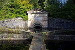 Upload another image | |||
| New Kilpatrick Parish Church | Kirk Road, Bearsden | 14/5/1971 | NS5432072280 | 55°55′17″N 4°19′58″W / 55.921471°N 4.332841°W / 55.921471; -4.332841 (New Kilpatrick Parish Church) | Early 19th-century church | 22130 | 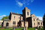 Upload another image |
| Kilmardinny House | Bearsden | 14/5/1971 | NS5501472743 | 55°55′33″N 4°19′19″W / 55.925837°N 4.321994°W / 55.925837; -4.321994 (Kilmardinny House) | Mid-19th-century country house, now Bearsden Arts Centre | 22135 |  Upload another image |
| Cawder House | Cadder, Bishopbriggs | 12/1/1971 | NS6058372691 | 55°55′37″N 4°13′58″W / 55.927018°N 4.232916°W / 55.927018; -4.232916 (Cawder House) | 17th-century country house, remodelled by David Hamilton | 22272 | 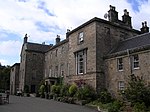 Upload another image |
| Old Parish Church of St. Mary | Cowgate, Kirkintilloch | 14/5/1971 | NS6521774078 | 55°56′27″N 4°09′34″W / 55.940792°N 4.159503°W / 55.940792; -4.159503 (Old Parish Church of St. Mary) | 17th-century church, now a museum | 36645 |  Upload another image |
| Auld Aisle Cemetery | Old Aisle Road, Oxgangs, Kirkintilloch | 14/5/1971 | NS6650373105 | 55°55′57″N 4°08′18″W / 55.932415°N 4.138449°W / 55.932415; -4.138449 (Auld Aisle Cemetery) | Former churchyard, including 18th-century watch-house | 36646 |  Upload another image |
| Luggie Water Aqueduct and Bridge | Barleybank, Kirkintilloch | 29/4/1986 | NS6574073935 | 55°56′23″N 4°09′04″W / 55.939655°N 4.151065°W / 55.939655; -4.151065 (Luggie Water Aqueduct and Bridge) | 18th century aqueduct by John Smeaton, carrying the Forth and Clyde Canal over a road and the Luggie Water | 36655 |  Upload another image |
| Factor's House, Dougalston | Dougalston, Milngavie | 14/5/1971 | NS5675173884 | 55°56′12″N 4°17′41″W / 55.936601°N 4.294826°W / 55.936601; -4.294826 (Factor's House, Dougalston) | 18th-century house | 37847 | Upload Photo |
| Glenshira, 27 Boclair Road | Bearsden | 25/4/2002 | NS5548272161 | 55°55′15″N 4°18′51″W / 55.920753°N 4.3142°W / 55.920753; -4.3142 (Glenshira, 27 Boclair Road) | Arts and Crafts house of 1926 | 48593 | Upload Photo |
Notes
- ^ Sometimes known as OSGB36, the grid reference (where provided) is based on the British national grid reference system used by the Ordnance Survey.
• "Guide to National Grid". Ordnance Survey. Retrieved 12 December 2007.
• "Get-a-map". Ordnance Survey. Retrieved 17 December 2007. - ^ Historic Environment Scotland assign a unique alphanumeric identifier to each designated site in Scotland, for listed buildings this always begins with "LB", for example "LB12345".
References
- ^ Guide to the Protection of Scotland’s Listed Buildings (PDF). Historic Scotland. 2009. p. 4. ISBN 978-1-84917-013-0. Retrieved 5 May 2010.
- ^ "What is Listing?". Historic Scotland. Retrieved 5 May 2010.
- ^ a b Scottish Historic Environment Policy (PDF). Historic Scotland. October 2008. pp. 24–25. ISBN 978-1-84917-002-4. Retrieved 5 May 2010.
- ^ Guide to the Protection of Scotland’s Listed Buildings, p. 17.
External links
![]() Media related to Category A listed buildings in East Dunbartonshire at Wikimedia Commons
Media related to Category A listed buildings in East Dunbartonshire at Wikimedia Commons
- v
- t
- e
- City of Aberdeen
- Aberdeenshire
- Angus
- Argyll and Bute
- Clackmannanshire
- Dumfries and Galloway
- City of Dundee
- East Ayrshire
- East Dunbartonshire
- East Lothian
- East Renfrewshire
- City of Edinburgh
- Falkirk
- Fife
- City of Glasgow
- Highland
- Inverclyde
- Midlothian
- Moray
- North Ayrshire
- North Lanarkshire
- Orkney
- Perth and Kinross
- Renfrewshire
- Scottish Borders
- Shetland
- South Ayrshire
- South Lanarkshire
- Stirling
- West Dunbartonshire
- West Lothian
- Western Isles (na h-Eileanan Siar)


