National Register of Historic Places listings in Harrison County, Kentucky
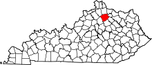
This is a list of the National Register of Historic Places listings in Harrison County, Kentucky.
This is intended to be a complete list of the properties and districts on the National Register of Historic Places in Harrison County, Kentucky, United States. The locations of National Register properties and districts for which the latitude and longitude coordinates are included may be seen in the map below.[1]
There 25 properties and districts listed on the National Register in the county.
This National Park Service list is complete through NPS recent listings posted September 5, 2024.[2]
Map all coordinates using OpenStreetMap
Download coordinates as:
- KML
- GPX (all coordinates)
- GPX (primary coordinates)
- GPX (secondary coordinates)
Current listings
| [3] | Name on the Register | Image | Date listed[4] | Location | City or town | Description |
|---|---|---|---|---|---|---|
| 1 | Archeological Site No. 15HR4 | Upload image | February 20, 1986 (#86000269) | Address Restricted | Lair vicinity | |
| 2 | Church of the Advent, Episcopal |  | December 22, 1978 (#78001339) | 122 N. Walnut St. 38°23′30″N 84°17′43″W / 38.391528°N 84.295278°W / 38.391528; -84.295278 (Church of the Advent, Episcopal) | Cynthiana | |
| 3 | Coleman-Desha Plantation |  | February 26, 1993 (#93000045) | U.S. Route 62 E., Oddville Pike, 1 mile northeast of Cynthiana 38°24′00″N 84°16′20″W / 38.4°N 84.272222°W / 38.4; -84.272222 (Coleman-Desha Plantation) | Cynthiana | |
| 4 | Confederate Monument in Cynthiana |  | July 17, 1997 (#97000695) | Battlegrove Cemetery, 0.75 miles east of the junction of S. Elmarch Ave. and Pike St. 38°23′41″N 84°16′51″W / 38.394722°N 84.280833°W / 38.394722; -84.280833 (Confederate Monument in Cynthiana) | Cynthiana | |
| 5 | Cynthiana Commercial District |  | October 19, 1982 (#82001567) | Pike St. from Church to Main Sts., and Main St. from Bridge to Pleasant Sts. 38°23′29″N 84°24′40″W / 38.391389°N 84.411111°W / 38.391389; -84.411111 (Cynthiana Commercial District) | Cynthiana | |
| 6 | Joel Frazer House | Upload image | June 23, 1983 (#83002786) | Off Kentucky Route 982 38°22′14″N 84°17′29″W / 38.37045°N 84.29139°W / 38.37045; -84.29139 (Joel Frazer House) | Cynthiana | Stone house built in 1810 by Thomas Metcalfe, a stonemason and then-future Kentucky state governor. |
| 7 | Handy Farm | 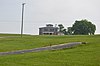 | November 25, 2005 (#05001316) | U.S. Route 62 38°23′40″N 84°17′07″W / 38.394444°N 84.285278°W / 38.394444; -84.285278 (Handy Farm) | Cynthiana | |
| 8 | Harrison County Courthouse |  | December 6, 1974 (#74000880) | 100 Main St. 38°23′21″N 84°17′52″W / 38.389167°N 84.297778°W / 38.389167; -84.297778 (Harrison County Courthouse) | Cynthiana | |
| 9 | Haviland House | Upload image | June 23, 1983 (#83002787) | Off U.S. Route 62 38°25′28″N 84°15′54″W / 38.424444°N 84.265°W / 38.424444; -84.265 (Haviland House) | Cynthiana | |
| 10 | John Hinkson House | Upload image | June 23, 1983 (#83002788) | Off U.S. Route 27 38°20′29″N 84°18′40″W / 38.341389°N 84.311111°W / 38.341389; -84.311111 (John Hinkson House) | Shawhan | |
| 11 | Kimbrough-Hehr House | Upload image | April 20, 1979 (#79000992) | U.S. Route 62 38°19′39″N 84°21′48″W / 38.3275°N 84.363333°W / 38.3275; -84.363333 (Kimbrough-Hehr House) | Broadwell | |
| 12 | William T. Lafferty House |  | April 10, 1980 (#80001538) | 548 E. Pike St. 38°23′15″N 84°16′53″W / 38.387500°N 84.281389°W / 38.387500; -84.281389 (William T. Lafferty House) | Cynthiana | |
| 13 | John Lair House | Upload image | June 23, 1983 (#83002789) | Old Lair Rd. 38°20′24″N 84°17′30″W / 38.34°N 84.291667°W / 38.34; -84.291667 (John Lair House) | Shawhan | |
| 14 | John McKee House | Upload image | June 23, 1983 (#83002790) | Cook Rd. 38°20′51″N 84°16′04″W / 38.3475°N 84.267778°W / 38.3475; -84.267778 (John McKee House) | Shawhan | |
| 15 | Samuel McMillan House | Upload image | June 23, 1983 (#83002791) | Off U.S. Route 62 38°20′13″N 84°21′39″W / 38.336944°N 84.360833°W / 38.336944; -84.360833 (Samuel McMillan House) | Shawhan | |
| 16 | Monticello |  | December 31, 1974 (#74000881) | Monticello Heights 38°22′59″N 84°17′37″W / 38.383056°N 84.293611°W / 38.383056; -84.293611 (Monticello) | Cynthiana | Mansion overlooking Cynthiana which was built around 1883. Now destroyed, carriage house shown. |
| 17 | Poplar Hill |  | November 7, 1976 (#76000896) | East of Cynthiana on Kentucky Route 32 38°22′59″N 84°16′32″W / 38.383056°N 84.275556°W / 38.383056; -84.275556 (Poplar Hill) | Cynthiana | |
| 18 | Wesley Roberts House |  | November 10, 1982 (#82001568) | 113-115 N. Main St. 38°23′28″N 84°17′51″W / 38.391111°N 84.297500°W / 38.391111; -84.297500 (Wesley Roberts House) | Cynthiana | |
| 19 | Second Battle of Cynthiana Battlefield |  | September 6, 2002 (#02000914) | 1 mile north of Cynthiana, east of Kentucky Route 36 38°24′28″N 84°18′39″W / 38.407778°N 84.310833°W / 38.407778; -84.310833 (Second Battle of Cynthiana Battlefield) | Cynthiana | |
| 20 | Joseph Shawhan House | Upload image | June 23, 1983 (#83002792) | Off U.S. Route 27 38°18′55″N 84°18′43″W / 38.315278°N 84.311944°W / 38.315278; -84.311944 (Joseph Shawhan House) | Shawhan | |
| 21 | Smith House | Upload image | June 23, 1983 (#83002793) | Off Lair Rd. 38°21′19″N 84°16′47″W / 38.355278°N 84.279722°W / 38.355278; -84.279722 (Smith House) | Shawhan | |
| 22 | Spur Gasoline Station |  | April 27, 1987 (#87000647) | 201 E. Bridge St. 38°23′15″N 84°17′46″W / 38.3875°N 84.296111°W / 38.3875; -84.296111 (Spur Gasoline Station) | Cynthiana | |
| 23 | Stone House of Indian Creek | Upload image | June 23, 1983 (#83002794) | Off U.S. Route 62 38°25′06″N 84°16′20″W / 38.418333°N 84.272222°W / 38.418333; -84.272222 (Stone House of Indian Creek) | Cynthiana | |
| 24 | Stoney Castle | Upload image | December 12, 1978 (#78001338) | West of Berry on Lafferty Pike 38°31′03″N 84°24′09″W / 38.5175°N 84.4025°W / 38.5175; -84.4025 (Stoney Castle) | Berry | |
| 25 | John Williams House | Upload image | June 23, 1983 (#83002795) | Off Kentucky Routes 32/36 38°22′11″N 84°15′15″W / 38.369722°N 84.254167°W / 38.369722; -84.254167 (John Williams House) | Shawhan |
See also
Wikimedia Commons has media related to National Register of Historic Places in Harrison County, Kentucky.
- List of National Historic Landmarks in Kentucky
- National Register of Historic Places listings in Kentucky
References
- ^ The latitude and longitude information provided in this table was derived originally from the National Register Information System, which has been found to be fairly accurate for about 99% of listings. Some locations in this table may have been corrected to current GPS standards.
- ^ National Park Service, United States Department of the Interior, "National Register of Historic Places: Weekly List Actions", retrieved September 5, 2024.
- ^ Numbers represent an alphabetical ordering by significant words. Various colorings, defined here, differentiate National Historic Landmarks and historic districts from other NRHP buildings, structures, sites or objects.
- ^ The eight-digit number below each date is the number assigned to each location in the National Register Information System database, which can be viewed by clicking the number.
- v
- t
- e
- List of U.S. National Historic Landmarks by state:
- Alabama
- Alaska
- Arizona
- Arkansas
- California
- Colorado
- Connecticut
- Delaware
- Florida
- Georgia
- Hawaii
- Idaho
- Illinois
- Indiana
- Iowa
- Kansas
- Kentucky
- Louisiana
- Maine
- Maryland
- Massachusetts
- Michigan
- Minnesota
- Mississippi
- Missouri
- Montana
- Nebraska
- Nevada
- New Hampshire
- New Jersey
- New Mexico
- New York
- North Carolina
- North Dakota
- Ohio
- Oklahoma
- Oregon
- Pennsylvania
- Rhode Island
- South Carolina
- South Dakota
- Tennessee
- Texas
- Utah
- Vermont
- Virginia
- Washington
- West Virginia
- Wisconsin
- Wyoming
 National Register of Historic Places portal
 Category


Municipalities and communities of Harrison County, Kentucky, United States | ||
|---|---|---|
County seat: Cynthiana | ||
| Cities |  | |
| Unincorporated communities | ||
| ||


