List of listed buildings in Whithorn, Dumfries and Galloway
This is a list of listed buildings in the civil parish of Whithorn, in Dumfries and Galloway, Scotland.
Map all coordinates using OpenStreetMap
Download coordinates as:
- KML
- GPX (all coordinates)
- GPX (primary coordinates)
- GPX (secondary coordinates)
List
| Name | Location | Date Listed | Grid Ref. [note 1] | Geo-coordinates | Notes | LB Number [note 2] | Image |
|---|---|---|---|---|---|---|---|
| 107 George Street | 54°43′54″N 4°25′01″W / 54.73155°N 4.41705°W / 54.73155; -4.41705 (107 George Street) | Category B | 43766 |  Upload Photo | |||
| 51 George Street | 54°43′59″N 4°24′57″W / 54.733175°N 4.415795°W / 54.733175; -4.415795 (51 George Street) | Category C(S) | 42194 | Upload Photo | |||
| 53 George Street And Entrance To Priory | 54°43′59″N 4°24′57″W / 54.73313°N 4.415823°W / 54.73313; -4.415823 (53 George Street And Entrance To Priory) | Category A | 42195 |  Upload another image | |||
| 55-57 (Odd Nos) George Street | 54°43′59″N 4°24′57″W / 54.732984°N 4.415939°W / 54.732984; -4.415939 (55-57 (Odd Nos) George Street) | Category A | 42196 | Upload Photo | |||
| 65, 67 And 69 George Street, Including Old Town Hall And Bell Tower | 54°43′58″N 4°24′59″W / 54.732707°N 4.416295°W / 54.732707; -4.416295 (65, 67 And 69 George Street, Including Old Town Hall And Bell Tower) | Category B | 42197 | 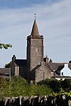 Upload another image | |||
| 77 George Street, The Clydesdale Bank, Walls And Railings | 54°43′56″N 4°24′59″W / 54.732355°N 4.416352°W / 54.732355; -4.416352 (77 George Street, The Clydesdale Bank, Walls And Railings) | Category C(S) | 42200 | Upload Photo | |||
| 79 George Street | 54°43′56″N 4°24′59″W / 54.732273°N 4.416425°W / 54.732273; -4.416425 (79 George Street) | Category B | 42201 | Upload Photo | |||
| 83 George Street | 54°43′56″N 4°24′59″W / 54.732145°N 4.41651°W / 54.732145; -4.41651 (83 George Street) | Category C(S) | 42203 | Upload Photo | |||
| 101 George Street | 54°43′54″N 4°25′01″W / 54.731707°N 4.416842°W / 54.731707; -4.416842 (101 George Street) | Category C(S) | 42210 | Upload Photo | |||
| 8 George Street | 54°44′03″N 4°24′52″W / 54.734099°N 4.414561°W / 54.734099; -4.414561 (8 George Street) | Category B | 42220 | Upload Photo | |||
| 58 George Street | 54°43′58″N 4°24′56″W / 54.732804°N 4.415462°W / 54.732804; -4.415462 (58 George Street) | Category C(S) | 42234 | Upload Photo | |||
| 118 George Street | 54°43′52″N 4°25′01″W / 54.731021°N 4.417018°W / 54.731021; -4.417018 (118 George Street) | Category C(S) | 42251 | Upload Photo | |||
| 122 George Street | 54°43′51″N 4°25′02″W / 54.730937°N 4.417137°W / 54.730937; -4.417137 (122 George Street) | Category C(S) | 42253 | Upload Photo | |||
| 25 St John Street | 54°44′09″N 4°24′53″W / 54.735919°N 4.414793°W / 54.735919; -4.414793 (25 St John Street) | Category B | 42259 | Upload Photo | |||
| 70 St John Street | 54°44′04″N 4°24′52″W / 54.734387°N 4.414562°W / 54.734387; -4.414562 (70 St John Street) | Category C(S) | 42263 | Upload Photo | |||
| Isle Of Whithorn, 66-70 (Even Nos) Main Street | 54°41′59″N 4°21′45″W / 54.699719°N 4.362369°W / 54.699719; -4.362369 (Isle Of Whithorn, 66-70 (Even Nos) Main Street) | Category C(S) | 19238 | Upload Photo | |||
| Isle Of Whithorn, 76-78 (Even Nos) Main Street | 54°41′58″N 4°21′44″W / 54.6995°N 4.362108°W / 54.6995; -4.362108 (Isle Of Whithorn, 76-78 (Even Nos) Main Street) | Category C(S) | 19240 | Upload Photo | |||
| Reiffer Park With Retaining Walls | 54°46′42″N 4°25′09″W / 54.778425°N 4.419037°W / 54.778425; -4.419037 (Reiffer Park With Retaining Walls) | Category B | 19247 | Upload Photo | |||
| Isle Of Whithorn, 38 Main Street, Low Isle House | 54°42′03″N 4°21′55″W / 54.700815°N 4.365211°W / 54.700815; -4.365211 (Isle Of Whithorn, 38 Main Street, Low Isle House) | Category B | 17070 | Upload Photo | |||
| Isle Of Whithorn, Isle Parish Church (Church Of Scotland) | 54°41′58″N 4°21′46″W / 54.699534°N 4.362684°W / 54.699534; -4.362684 (Isle Of Whithorn, Isle Parish Church (Church Of Scotland)) | Category B | 16722 | Upload Photo | |||
| 71 And 73 George Street | 54°43′57″N 4°24′58″W / 54.732619°N 4.416212°W / 54.732619; -4.416212 (71 And 73 George Street) | Category B | 42198 | Upload Photo | |||
| 81 George Street | 54°43′56″N 4°24′59″W / 54.732208°N 4.416499°W / 54.732208; -4.416499 (81 George Street) | Category C(S) | 42202 | Upload Photo | |||
| 85 George Street | 54°43′55″N 4°24′59″W / 54.732082°N 4.416507°W / 54.732082; -4.416507 (85 George Street) | Category C(S) | 42204 | Upload Photo | |||
| 91-93 (Odd Nos) George Street | 54°43′55″N 4°25′01″W / 54.731959°N 4.416841°W / 54.731959; -4.416841 (91-93 (Odd Nos) George Street) | Category C(S) | 42207 | Upload Photo | |||
| 109 George Street | 54°43′53″N 4°25′02″W / 54.73144°N 4.417152°W / 54.73144; -4.417152 (109 George Street) | Category B | 42212 | Upload Photo | |||
| 2 George Street (Corner With St John Street) The Cross House | 54°44′04″N 4°24′52″W / 54.734326°N 4.41445°W / 54.734326; -4.41445 (2 George Street (Corner With St John Street) The Cross House) | Category C(S) | 42217 | Upload Photo | |||
| 12-14 (Even Nos) George Street And Rubble Wall To Rear | 54°44′02″N 4°24′53″W / 54.733835°N 4.414747°W / 54.733835; -4.414747 (12-14 (Even Nos) George Street And Rubble Wall To Rear) | Category B | 42222 | Upload Photo | |||
| 26 George Street | 54°44′01″N 4°24′54″W / 54.733535°N 4.414884°W / 54.733535; -4.414884 (26 George Street) | Category B | 42226 | Upload Photo | |||
| 30-32 (Even Nos) George Street | 54°44′00″N 4°24′54″W / 54.733406°N 4.415048°W / 54.733406; -4.415048 (30-32 (Even Nos) George Street) | Category B | 42228 | Upload Photo | |||
| 60 George Street | 54°43′58″N 4°24′56″W / 54.732677°N 4.415548°W / 54.732677; -4.415548 (60 George Street) | Category B | 42235 | Upload Photo | |||
| 96 And 98 George Street | 54°43′54″N 4°24′58″W / 54.731683°N 4.41625°W / 54.731683; -4.41625 (96 And 98 George Street) | Category C(S) | 42241 | Upload Photo | |||
| 102 George Street | 54°43′53″N 4°24′59″W / 54.731463°N 4.416485°W / 54.731463; -4.416485 (102 George Street) | Category B | 42243 | Upload Photo | |||
| 112 George Street | 54°43′52″N 4°25′01″W / 54.731177°N 4.416841°W / 54.731177; -4.416841 (112 George Street) | Category B | 42248 | Upload Photo | |||
| 114 George Street | 54°43′52″N 4°25′01″W / 54.731131°N 4.416885°W / 54.731131; -4.416885 (114 George Street) | Category C(S) | 42249 | Upload Photo | |||
| 126 George Street | 54°43′51″N 4°25′02″W / 54.730783°N 4.417206°W / 54.730783; -4.417206 (126 George Street) | Category B | 42255 | Upload Photo | |||
| 33 High Street | 54°43′46″N 4°25′08″W / 54.729474°N 4.418821°W / 54.729474; -4.418821 (33 High Street) | Category C(S) | 42258 | Upload Photo | |||
| 53 St John Street, Whithorn Town Hall With Gate, Railings And Quadrant Wall | 54°44′06″N 4°24′54″W / 54.73489°N 4.414996°W / 54.73489; -4.414996 (53 St John Street, Whithorn Town Hall With Gate, Railings And Quadrant Wall) | Category C(S) | 42261 | Upload Photo | |||
| Whithorn Priory | 54°44′01″N 4°25′01″W / 54.733664°N 4.416974°W / 54.733664; -4.416974 (Whithorn Priory) | Category A | 42266 |  Upload another image | |||
| Isle Of Whithorn, 24-30 (Even Nos) Main Street | 54°42′03″N 4°21′59″W / 54.700782°N 4.366435°W / 54.700782; -4.366435 (Isle Of Whithorn, 24-30 (Even Nos) Main Street) | Category C(S) | 19233 | Upload Photo | |||
| Isle Of Whithorn, 86 Main Street | 54°41′57″N 4°21′42″W / 54.699245°N 4.361782°W / 54.699245; -4.361782 (Isle Of Whithorn, 86 Main Street) | Category C(S) | 19243 | Upload Photo | |||
| Isle Of Whithorn, 12 Main Street | 54°42′04″N 4°22′03″W / 54.701112°N 4.367448°W / 54.701112; -4.367448 (Isle Of Whithorn, 12 Main Street) | Category C(S) | 16724 | Upload Photo | |||
| Isle Of Whithorn, 14 Main Street | 54°42′04″N 4°22′03″W / 54.701059°N 4.367444°W / 54.701059; -4.367444 (Isle Of Whithorn, 14 Main Street) | Category C(S) | 16725 | Upload Photo | |||
| Castlewigg Steading, Principal Range | 54°45′33″N 4°26′48″W / 54.759145°N 4.446751°W / 54.759145; -4.446751 (Castlewigg Steading, Principal Range) | Category C(S) | 16750 | Upload Photo | |||
| Bruce Street, Museum And Custodian's House And Boundary Walls | 54°44′00″N 4°25′00″W / 54.733363°N 4.416754°W / 54.733363; -4.416754 (Bruce Street, Museum And Custodian's House And Boundary Walls) | Category B | 42185 | Upload Photo | |||
| 17 George Street, The Central Cafe | 54°44′02″N 4°24′55″W / 54.733888°N 4.415201°W / 54.733888; -4.415201 (17 George Street, The Central Cafe) | Category C(S) | 42191 | Upload Photo | |||
| 89 George Street | 54°43′55″N 4°25′00″W / 54.731999°N 4.416626°W / 54.731999; -4.416626 (89 George Street) | Category B | 42206 | Upload Photo | |||
| 111-113 (Odd Nos) George Street | 54°43′53″N 4°25′02″W / 54.731394°N 4.417211°W / 54.731394; -4.417211 (111-113 (Odd Nos) George Street) | Category C(S) | 42213 | Upload Photo | |||
| 137 George Street | 54°43′51″N 4°25′04″W / 54.730709°N 4.417745°W / 54.730709; -4.417745 (137 George Street) | Category B | 42216 | Upload Photo | |||
| 56 George Street | 54°43′58″N 4°24′56″W / 54.732858°N 4.415465°W / 54.732858; -4.415465 (56 George Street) | Category C(S) | 42233 | Upload Photo | |||
| 108 George Street | 54°43′53″N 4°25′00″W / 54.731269°N 4.416722°W / 54.731269; -4.416722 (108 George Street) | Category B | 42246 | Upload Photo | |||
| 130 George Street | 54°43′50″N 4°25′02″W / 54.730664°N 4.417308°W / 54.730664; -4.417308 (130 George Street) | Category C(S) | 42257 | Upload Photo | |||
| Whithorn Manse | 54°44′04″N 4°25′09″W / 54.734348°N 4.419174°W / 54.734348; -4.419174 (Whithorn Manse) | Category B | 42264 | Upload Photo | |||
| Isle Of Whithorn, 80 Main Street | 54°41′58″N 4°21′43″W / 54.699403°N 4.361993°W / 54.699403; -4.361993 (Isle Of Whithorn, 80 Main Street) | Category C(S) | 19241 | Upload Photo | |||
| Isle Of Whithorn, Isle Castle | 54°42′05″N 4°21′57″W / 54.701333°N 4.365815°W / 54.701333; -4.365815 (Isle Of Whithorn, Isle Castle) | Category A | 16751 | Upload Photo | |||
| Isle Of Whithorn, Harbour Row, Warehouses Including Isle Smugglers | 54°41′54″N 4°21′46″W / 54.698344°N 4.362847°W / 54.698344; -4.362847 (Isle Of Whithorn, Harbour Row, Warehouses Including Isle Smugglers) | Category B | 16755 | Upload Photo | |||
| 11 George Street | 54°44′02″N 4°24′54″W / 54.734025°N 4.415115°W / 54.734025; -4.415115 (11 George Street) | Category C(S) | 42189 | Upload Photo | |||
| 28 George Street | 54°44′01″N 4°24′54″W / 54.733489°N 4.414944°W / 54.733489; -4.414944 (28 George Street) | Category B | 42227 | Upload Photo | |||
| 52-54 (Even Nos) George Street | 54°43′58″N 4°24′55″W / 54.732915°N 4.415329°W / 54.732915; -4.415329 (52-54 (Even Nos) George Street) | Category C(S) | 42232 | Upload Photo | |||
| 94 George Street | 54°43′54″N 4°24′58″W / 54.731747°N 4.416192°W / 54.731747; -4.416192 (94 George Street) | Category B | 42240 | Upload Photo | |||
| 120 George Street | 54°43′52″N 4°25′01″W / 54.731021°N 4.417018°W / 54.731021; -4.417018 (120 George Street) | Category C(S) | 42252 | Upload Photo | |||
| Whithorn Parish Church, (Church Of Scotland) And Graveyard | 54°44′02″N 4°25′03″W / 54.733822°N 4.41762°W / 54.733822; -4.41762 (Whithorn Parish Church, (Church Of Scotland) And Graveyard) | Category B | 42265 | Upload Photo | |||
| Isle Of Whithorn, 5 Tonderghie Road | 54°42′02″N 4°22′02″W / 54.700558°N 4.367307°W / 54.700558; -4.367307 (Isle Of Whithorn, 5 Tonderghie Road) | Category C(S) | 19246 | Upload Photo | |||
| Tonderghie House | 54°41′31″N 4°25′02″W / 54.691924°N 4.417144°W / 54.691924; -4.417144 (Tonderghie House) | Category A | 19248 |  Upload another image | |||
| Isle Of Whithorn, 16 Main Street | 54°42′04″N 4°22′02″W / 54.701016°N 4.367318°W / 54.701016; -4.367318 (Isle Of Whithorn, 16 Main Street) | Category B | 16726 | Upload Photo | |||
| Broughton Mains Farmhouse | 54°46′34″N 4°24′34″W / 54.776071°N 4.409488°W / 54.776071; -4.409488 (Broughton Mains Farmhouse) | Category B | 16740 | Upload Photo | |||
| Isle Of Whithorn, Harbour | 54°41′53″N 4°21′48″W / 54.698125°N 4.363471°W / 54.698125; -4.363471 (Isle Of Whithorn, Harbour) | Category B | 16753 | Upload Photo | |||
| 7-9 (Odd Nos) George Street | 54°44′03″N 4°24′54″W / 54.734117°N 4.415012°W / 54.734117; -4.415012 (7-9 (Odd Nos) George Street) | Category B | 42188 | Upload Photo | |||
| 103-105 (Odd Nos) George Street | 54°43′54″N 4°25′01″W / 54.73167°N 4.416901°W / 54.73167; -4.416901 (103-105 (Odd Nos) George Street) | Category C(S) | 42211 | Upload Photo | |||
| 6 George Street | 54°44′03″N 4°24′52″W / 54.734172°N 4.414503°W / 54.734172; -4.414503 (6 George Street) | Category B | 42219 | Upload Photo | |||
| 16-18 (Even Nos) George Street | 54°44′01″N 4°24′53″W / 54.733736°N 4.414741°W / 54.733736; -4.414741 (16-18 (Even Nos) George Street) | Category B | 42223 | Upload Photo | |||
| 34 George Street | 54°44′00″N 4°24′54″W / 54.733306°N 4.415119°W / 54.733306; -4.415119 (34 George Street) | Category B | 42229 | Upload Photo | |||
| 36 And 38 George Street | 54°44′00″N 4°24′55″W / 54.733251°N 4.415147°W / 54.733251; -4.415147 (36 And 38 George Street) | Category C(S) | 42230 | Upload Photo | |||
| Isle Of Whithorn, 20 Main Street | 54°42′03″N 4°22′02″W / 54.700912°N 4.367126°W / 54.700912; -4.367126 (Isle Of Whithorn, 20 Main Street) | Category B | 19231 | Upload Photo | |||
| Isle Of Whithorn, 62 Main Street | 54°41′59″N 4°21′45″W / 54.699833°N 4.362546°W / 54.699833; -4.362546 (Isle Of Whithorn, 62 Main Street) | Category C(S) | 19236 | Upload Photo | |||
| Isle Of Whithorn, 64 Main Street | 54°41′59″N 4°21′45″W / 54.699754°N 4.362448°W / 54.699754; -4.362448 (Isle Of Whithorn, 64 Main Street) | Category C(S) | 19237 | Upload Photo | |||
| Isle Of Whithorn, 72-74 (Even Nos) Main Street | 54°41′59″N 4°21′44″W / 54.699596°N 4.362222°W / 54.699596; -4.362222 (Isle Of Whithorn, 72-74 (Even Nos) Main Street) | Category C(S) | 19239 | Upload Photo | |||
| Isle Of Whithorn, 82 Main Street | 54°41′58″N 4°21′43″W / 54.69935°N 4.361928°W / 54.69935; -4.361928 (Isle Of Whithorn, 82 Main Street) | Category B | 19242 | Upload Photo | |||
| Isle Of Whithorn, 3 Tonderghie Road | 54°42′02″N 4°22′02″W / 54.700639°N 4.367296°W / 54.700639; -4.367296 (Isle Of Whithorn, 3 Tonderghie Road) | Category B | 19245 | Upload Photo | |||
| Isle Of Whithorn, Harbour Row, Harbour House, The Wigtown Bay Sailing Club | 54°41′57″N 4°21′44″W / 54.699096°N 4.362084°W / 54.699096; -4.362084 (Isle Of Whithorn, Harbour Row, Harbour House, The Wigtown Bay Sailing Club) | Category C(S) | 16754 | Upload Photo | |||
| Castlewigg Castle | 54°45′32″N 4°26′42″W / 54.758936°N 4.445045°W / 54.758936; -4.445045 (Castlewigg Castle) | Category B | 16741 | Upload Photo | |||
| 5 George Street | 54°44′03″N 4°24′54″W / 54.734153°N 4.415014°W / 54.734153; -4.415014 (5 George Street) | Category C(S) | 42187 | Upload Photo | |||
| 19 George Street, The Royal Bank Of Scotland | 54°44′02″N 4°24′55″W / 54.733841°N 4.415322°W / 54.733841; -4.415322 (19 George Street, The Royal Bank Of Scotland) | Category C(S) | 42192 | Upload Photo | |||
| 99 George Street | 54°43′54″N 4°25′00″W / 54.731789°N 4.4168°W / 54.731789; -4.4168 (99 George Street) | Category C(S) | 42209 | Upload Photo | |||
| 125-127 (Odd Nos) George Street | 54°43′52″N 4°25′03″W / 54.73099°N 4.417638°W / 54.73099; -4.417638 (125-127 (Odd Nos) George Street) | Category B | 42214 | Upload Photo | |||
| 129 George Street | 54°43′51″N 4°25′04″W / 54.730936°N 4.417665°W / 54.730936; -4.417665 (129 George Street) | Category B | 42215 | Upload Photo | |||
| 70 And 72 George Street | 54°43′56″N 4°24′56″W / 54.732226°N 4.415645°W / 54.732226; -4.415645 (70 And 72 George Street) | Category B | 42238 | Upload Photo | |||
| 124 George Street | 54°43′51″N 4°25′02″W / 54.730873°N 4.417196°W / 54.730873; -4.417196 (124 George Street) | Category C(S) | 42254 | Upload Photo | |||
| Isle Of Whithorn, 58 Main Street | 54°42′00″N 4°21′46″W / 54.700008°N 4.362758°W / 54.700008; -4.362758 (Isle Of Whithorn, 58 Main Street) | Category C(S) | 19234 | Upload Photo | |||
| Tonderghie Steadings | 54°41′22″N 4°25′07″W / 54.68937°N 4.418544°W / 54.68937; -4.418544 (Tonderghie Steadings) | Category A | 19249 | Upload Photo | |||
| Isle Of Whithorn, St Ninians Kirk | 54°41′53″N 4°21′39″W / 54.698043°N 4.36075°W / 54.698043; -4.36075 (Isle Of Whithorn, St Ninians Kirk) | Category B | 16723 | 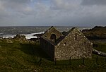 Upload another image | |||
| Isle Of Whithorn, 13 Main Street, Captain's Garden, Formerly Sea View | 54°42′01″N 4°21′48″W / 54.700301°N 4.363427°W / 54.700301; -4.363427 (Isle Of Whithorn, 13 Main Street, Captain's Garden, Formerly Sea View) | Category B | 43736 | Upload Photo | |||
| 29 George Street And Walled Garden | 54°44′01″N 4°24′55″W / 54.733579°N 4.415369°W / 54.733579; -4.415369 (29 George Street And Walled Garden) | Category B | 42193 | Upload Photo | |||
| 87 George Street | 54°43′55″N 4°25′00″W / 54.732045°N 4.416582°W / 54.732045; -4.416582 (87 George Street) | Category C(S) | 42205 | Upload Photo | |||
| 4 George Street | 54°44′03″N 4°24′52″W / 54.734271°N 4.414478°W / 54.734271; -4.414478 (4 George Street) | Category B | 42218 | Upload Photo | |||
| George Street, The Grapes Hotel | 54°44′02″N 4°24′53″W / 54.734017°N 4.414587°W / 54.734017; -4.414587 (George Street, The Grapes Hotel) | Category C(S) | 42221 | Upload Photo | |||
| 22 And 24 George Street | 54°44′01″N 4°24′53″W / 54.733618°N 4.414765°W / 54.733618; -4.414765 (22 And 24 George Street) | Category B | 42225 | Upload Photo | |||
| 42-44 (Even Nos) George Street | 54°43′59″N 4°24′55″W / 54.733159°N 4.415266°W / 54.733159; -4.415266 (42-44 (Even Nos) George Street) | Category C(S) | 42231 | Upload Photo | |||
| 92 George Street | 54°43′55″N 4°24′58″W / 54.731821°N 4.416072°W / 54.731821; -4.416072 (92 George Street) | Category B | 42239 | Upload Photo | |||
| 104 George Street | 54°43′53″N 4°25′00″W / 54.73138°N 4.416589°W / 54.73138; -4.416589 (104 George Street) | Category C(S) | 42244 | Upload Photo | |||
| 106 George Street | 54°43′53″N 4°25′00″W / 54.731315°N 4.416663°W / 54.731315; -4.416663 (106 George Street) | Category C(S) | 42245 | Upload Photo | |||
| 128 George Street | 54°43′51″N 4°25′02″W / 54.73071°N 4.417279°W / 54.73071; -4.417279 (128 George Street) | Category C(S) | 42256 | Upload Photo | |||
| 27 St John Street, "The Neuk" And Boundary Walls | 54°44′09″N 4°24′54″W / 54.7358°N 4.414926°W / 54.7358; -4.414926 (27 St John Street, "The Neuk" And Boundary Walls) | Category B | 42260 | Upload Photo | |||
| Isle Of Whithorn, 22 Main Street, The Queens Arms | 54°42′03″N 4°22′01″W / 54.700889°N 4.366907°W / 54.700889; -4.366907 (Isle Of Whithorn, 22 Main Street, The Queens Arms) | Category C(S) | 19232 | Upload Photo | |||
| Castlewigg Hotel | 54°45′22″N 4°26′11″W / 54.75603°N 4.436274°W / 54.75603; -4.436274 (Castlewigg Hotel) | Category B | 16742 | Upload Photo | |||
| Isle Of Whithorn, Isle Farm | 54°42′35″N 4°21′41″W / 54.709746°N 4.36126°W / 54.709746; -4.36126 (Isle Of Whithorn, Isle Farm) | Category B | 16752 | Upload Photo | |||
| Isle Of Whithorn, 5 Main Street | 54°42′03″N 4°22′02″W / 54.70081°N 4.36729°W / 54.70081; -4.36729 (Isle Of Whithorn, 5 Main Street) | Category C(S) | 44188 | Upload Photo | |||
| Isle Of Whithorn, 88 Main Street | 54°41′57″N 4°21′42″W / 54.699184°N 4.361717°W / 54.699184; -4.361717 (Isle Of Whithorn, 88 Main Street) | Category C(S) | 43737 | Upload Photo | |||
| 13-15 (Odd Nos) George Street | 54°44′02″N 4°24′55″W / 54.733996°N 4.415222°W / 54.733996; -4.415222 (13-15 (Odd Nos) George Street) | Category B | 42190 | Upload Photo | |||
| 75 George Street, Registrar's Office | 54°43′57″N 4°24′58″W / 54.732483°N 4.416235°W / 54.732483; -4.416235 (75 George Street, Registrar's Office) | Category B | 42199 | Upload Photo | |||
| 97 George Street | 54°43′55″N 4°25′00″W / 54.731835°N 4.416756°W / 54.731835; -4.416756 (97 George Street) | Category B | 42208 | Upload Photo | |||
| 20 George Street | 54°44′01″N 4°24′53″W / 54.733707°N 4.414848°W / 54.733707; -4.414848 (20 George Street) | Category B | 42224 | Upload Photo | |||
| 62-64 (Even Nos) George Street | 54°43′57″N 4°24′56″W / 54.732586°N 4.415605°W / 54.732586; -4.415605 (62-64 (Even Nos) George Street) | Category C(S) | 42236 | Upload Photo | |||
| Post Office, 68 George Street | 54°43′57″N 4°24′56″W / 54.732387°N 4.415639°W / 54.732387; -4.415639 (Post Office, 68 George Street) | Category B | 42237 | Upload Photo | |||
| 100 George Street | 54°43′54″N 4°24′59″W / 54.731545°N 4.416412°W / 54.731545; -4.416412 (100 George Street) | Category B | 42242 | Upload Photo | |||
| 110 George Street | 54°43′52″N 4°25′01″W / 54.731213°N 4.416812°W / 54.731213; -4.416812 (110 George Street) | Category B | 42247 | Upload Photo | |||
| 116 George Street | 54°43′52″N 4°25′01″W / 54.731094°N 4.416945°W / 54.731094; -4.416945 (116 George Street) | Category C(S) | 42250 | Upload Photo | |||
| 22 St John Street, St John's Garage (Former UP Church) | 54°44′11″N 4°24′52″W / 54.73635°N 4.414368°W / 54.73635; -4.414368 (22 St John Street, St John's Garage (Former UP Church)) | Category C(S) | 42262 |  Upload another image | |||
| Isle Of Whithorn, 60 Main Street | 54°42′00″N 4°21′45″W / 54.699904°N 4.362597°W / 54.699904; -4.362597 (Isle Of Whithorn, 60 Main Street) | Category C(S) | 19235 | Upload Photo | |||
| Isle Of Whithorn, Sea Breeze And Rosnay, With Sea Wall | 54°42′01″N 4°21′49″W / 54.700358°N 4.363725°W / 54.700358; -4.363725 (Isle Of Whithorn, Sea Breeze And Rosnay, With Sea Wall) | Category C(S) | 19244 | Upload Photo | |||
| Isle Of Whithorn, 56 Main Street | 54°42′00″N 4°21′46″W / 54.700096°N 4.362856°W / 54.700096; -4.362856 (Isle Of Whithorn, 56 Main Street) | Category B | 17071 | Upload Photo | |||
| Isle Of Whithorn, 18 Main Street | 54°42′03″N 4°22′02″W / 54.700965°N 4.367175°W / 54.700965; -4.367175 (Isle Of Whithorn, 18 Main Street) | Category B | 16727 | Upload Photo | |||
| George Street, St Martin And St Ninian Roman Catholic Church, Including Quadrant Walls | 54°43′55″N 4°24′57″W / 54.731998°N 4.415772°W / 54.731998; -4.415772 (George Street, St Martin And St Ninian Roman Catholic Church, Including Quadrant Walls) | Category C(S) | 51291 | Upload Photo |
Key
The scheme for classifying buildings in Scotland is:
- Category A: "buildings of national or international importance, either architectural or historic; or fine, little-altered examples of some particular period, style or building type."[1]
- Category B: "buildings of regional or more than local importance; or major examples of some particular period, style or building type, which may have been altered."[1]
- Category C: "buildings of local importance; lesser examples of any period, style, or building type, as originally constructed or moderately altered; and simple traditional buildings which group well with other listed buildings."[1]
In March 2016 there were 47,288 listed buildings in Scotland. Of these, 8% were Category A, and 50% were Category B, with the remaining 42% being Category C.[2]
Notes
- ^ Sometimes known as OSGB36, the grid reference (where provided) is based on the British national grid reference system used by the Ordnance Survey.
• "Guide to National Grid". Ordnance Survey. Retrieved 12 December 2007.
• "Get-a-map". Ordnance Survey. Retrieved 17 December 2007. - ^ Historic Environment Scotland assign a unique alphanumeric identifier to each designated site in Scotland, for listed buildings this always begins with "LB", for example "LB12345".
References
- All entries, addresses and coordinates are based on data from Historic Scotland. This data falls under the Open Government Licence
- ^ a b c "What is Listing?". Historic Environment Scotland. Retrieved 29 May 2018.
- ^ Scotland's Historic Environment Audit 2016 (PDF). Historic Environment Scotland and the Built Environment Forum Scotland. pp. 15–16. Retrieved 29 May 2018.
- v
- t
- e
- Annan
- Applegarth
- Caerlaverock
- Canonbie
- Closeburn
- Cummertrees
- Dalton
- Dornock
- Dryfesdale
- Dumfries
- Dunscore
- Durisdeer
- Eskdalemuir
- Ewes
- Glencairn
- Gretna
- Half Morton
- Hoddom
- Holywood
- Hutton and Corrie
- Johnstone
- Keir
- Kirkconnel
- Kirkmahoe
- Kirkmichael
- Kirkpatrick-Fleming
- Kirkpatrick-Juxta
- Langholm
- Lochmaben
- Lockerbie
- Middlebie
- Moffat
- Morton
- Mouswald
- Penpont
- Ruthwell
- Sanquhar
- St Mungo
- Tinwald
- Torthorwald
- Tundergarth
- Tynron
- Wamphray
- Westerkirk
- Anwoth
- Balmaclellan
- Balmaghie
- Borgue
- Buittle
- Carsphairn
- Castle Douglas
- Colvend and Southwick
- Crossmichael
- Dalbeattie
- Dalry
- Gatehouse of Fleet
- Girthon
- Kells
- Kelton
- Kirkbean
- Kirkcudbright
- Kirkgunzeon
- Kirkmabreck
- Kirkpatrick Durham
- Kirkpatrick Irongray
- Lochrutton
- Minnigaff
- New Abbey
- New Galloway
- Newton Stewart
- Parton
- Rerrick
- Terregles
- Tongland
- Troqueer
- Twynholm
- Urr


