List of listed buildings in Tongland, Dumfries and Galloway
This is a list of listed buildings in the civil parish of Tongland in Dumfries and Galloway, Scotland.
Map all coordinates using OpenStreetMap
Download coordinates as:
- KML
- GPX (all coordinates)
- GPX (primary coordinates)
- GPX (secondary coordinates)
List
| Name | Location | Date Listed | Grid Ref. [note 1] | Geo-coordinates | Notes | LB Number [note 2] | Image |
|---|---|---|---|---|---|---|---|
| Tarff, Old Bridge Of Tarff | 54°53′00″N 4°03′20″W / 54.883436°N 4.055631°W / 54.883436; -4.055631 (Tarff, Old Bridge Of Tarff) | Category B | 17084 |  Upload Photo | |||
| Kirkconnel Farmhouse And Steading | 54°55′12″N 4°04′06″W / 54.919989°N 4.068434°W / 54.919989; -4.068434 (Kirkconnel Farmhouse And Steading) | Category B | 17118 | Upload Photo | |||
| Argrennan House Walled Garden | 54°53′57″N 4°00′14″W / 54.899221°N 4.003876°W / 54.899221; -4.003876 (Argrennan House Walled Garden) | Category B | 43477 | Upload Photo | |||
| Bogra House | 54°52′35″N 4°01′22″W / 54.876257°N 4.022797°W / 54.876257; -4.022797 (Bogra House) | Category B | 17116 | Upload Photo | |||
| Brook House, Ringford | 54°53′50″N 4°02′44″W / 54.897257°N 4.045668°W / 54.897257; -4.045668 (Brook House, Ringford) | Category B | 17117 | Upload Photo | |||
| Tongland Bridge | 54°51′28″N 4°02′21″W / 54.857764°N 4.039165°W / 54.857764; -4.039165 (Tongland Bridge) | Category A | 17125 | 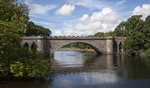 Upload another image | |||
| Tongland Parish Church (Church Of Scotland) And Churchyard | 54°51′47″N 4°01′49″W / 54.863011°N 4.030174°W / 54.863011; -4.030174 (Tongland Parish Church (Church Of Scotland) And Churchyard) | Category B | 17127 | Upload Photo | |||
| Argrennan House | 54°54′03″N 4°00′22″W / 54.900902°N 4.006049°W / 54.900902; -4.006049 (Argrennan House) | Category A | 17114 | 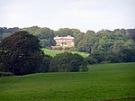 Upload another image | |||
| Low Bridge Of Tarff | 54°51′51″N 4°03′02″W / 54.864171°N 4.050474°W / 54.864171; -4.050474 (Low Bridge Of Tarff) | Category B | 17120 | Upload Photo | |||
| Argrennan Lodge | 54°54′07″N 4°00′37″W / 54.90193°N 4.010202°W / 54.90193; -4.010202 (Argrennan Lodge) | Category B | 17115 | Upload Photo | |||
| Galloway Electric Power Scheme, Tongland Power Station, Surge Tower And Valve House, Including Boundary Walls | 54°51′35″N 4°02′04″W / 54.85975°N 4.034404°W / 54.85975; -4.034404 (Galloway Electric Power Scheme, Tongland Power Station, Surge Tower And Valve House, Including Boundary Walls) | Category A | 17126 |  Upload another image | |||
| Tongland, Old Tongland Bridge | 54°51′38″N 4°01′54″W / 54.86066°N 4.031536°W / 54.86066; -4.031536 (Tongland, Old Tongland Bridge) | Category A | 17123 | Upload Photo | |||
| Tongland Abbey, Tongland Parish Churchyard | 54°51′47″N 4°01′50″W / 54.863103°N 4.030584°W / 54.863103; -4.030584 (Tongland Abbey, Tongland Parish Churchyard) | Category B | 17124 | Upload Photo | |||
| Tarff, High Bridge Of Tarff | 54°53′01″N 4°03′19″W / 54.883746°N 4.055335°W / 54.883746; -4.055335 (Tarff, High Bridge Of Tarff) | Category B | 17119 | Upload Photo |
Key
The scheme for classifying buildings in Scotland is:
- Category A: "buildings of national or international importance, either architectural or historic; or fine, little-altered examples of some particular period, style or building type."[1]
- Category B: "buildings of regional or more than local importance; or major examples of some particular period, style or building type, which may have been altered."[1]
- Category C: "buildings of local importance; lesser examples of any period, style, or building type, as originally constructed or moderately altered; and simple traditional buildings which group well with other listed buildings."[1]
In March 2016 there were 47,288 listed buildings in Scotland. Of these, 8% were Category A, and 50% were Category B, with the remaining 42% being Category C.[2]
Notes
- ^ Sometimes known as OSGB36, the grid reference (where provided) is based on the British national grid reference system used by the Ordnance Survey.
• "Guide to National Grid". Ordnance Survey. Retrieved 12 December 2007.
• "Get-a-map". Ordnance Survey. Retrieved 17 December 2007. - ^ Historic Environment Scotland assign a unique alphanumeric identifier to each designated site in Scotland, for listed buildings this always begins with "LB", for example "LB12345".
References
- All entries, addresses and coordinates are based on data from Historic Scotland. This data falls under the Open Government Licence
- ^ a b c "What is Listing?". Historic Environment Scotland. Retrieved 29 May 2018.
- ^ Scotland's Historic Environment Audit 2016 (PDF). Historic Environment Scotland and the Built Environment Forum Scotland. pp. 15–16. Retrieved 29 May 2018.
- v
- t
- e
- Annan
- Applegarth
- Caerlaverock
- Canonbie
- Closeburn
- Cummertrees
- Dalton
- Dornock
- Dryfesdale
- Dumfries
- Dunscore
- Durisdeer
- Eskdalemuir
- Ewes
- Glencairn
- Gretna
- Half Morton
- Hoddom
- Holywood
- Hutton and Corrie
- Johnstone
- Keir
- Kirkconnel
- Kirkmahoe
- Kirkmichael
- Kirkpatrick-Fleming
- Kirkpatrick-Juxta
- Langholm
- Lochmaben
- Lockerbie
- Middlebie
- Moffat
- Morton
- Mouswald
- Penpont
- Ruthwell
- Sanquhar
- St Mungo
- Tinwald
- Torthorwald
- Tundergarth
- Tynron
- Wamphray
- Westerkirk
- Anwoth
- Balmaclellan
- Balmaghie
- Borgue
- Buittle
- Carsphairn
- Castle Douglas
- Colvend and Southwick
- Crossmichael
- Dalbeattie
- Dalry
- Gatehouse of Fleet
- Girthon
- Kells
- Kelton
- Kirkbean
- Kirkcudbright
- Kirkgunzeon
- Kirkmabreck
- Kirkpatrick Durham
- Kirkpatrick Irongray
- Lochrutton
- Minnigaff
- New Abbey
- New Galloway
- Newton Stewart
- Parton
- Rerrick
- Terregles
- Tongland
- Troqueer
- Twynholm
- Urr


