List of listed buildings in Scone, Perth and Kinross
This is a list of listed buildings in the parish of Scone in Perth and Kinross, Scotland.
Map all coordinates using OpenStreetMap
Download coordinates as:
- KML
- GPX (all coordinates)
- GPX (primary coordinates)
- GPX (secondary coordinates)
List
| Name | Location | Date Listed | Grid Ref. [note 1] | Geo-coordinates | Notes | LB Number [note 2] | Image |
|---|---|---|---|---|---|---|---|
| Scone Palace, Old Scone mercat cross | 56°25′26″N 3°26′06″W / 56.423765°N 3.435058°W / 56.423765; -3.435058 (Scone Palace, Old Scone mercat cross) | Category A | 19876 |  Upload another image | |||
| Cross Of New Scone Junction Of Cross Street And Abbey Road, New Scone | 56°24′56″N 3°24′21″W / 56.415671°N 3.4059°W / 56.415671; -3.4059 (Cross Of New Scone Junction Of Cross Street And Abbey Road, New Scone) | Category B | 18362 |  Upload Photo | |||
| 11 Mansfield Road, New Scone | 56°25′12″N 3°24′03″W / 56.419862°N 3.400834°W / 56.419862; -3.400834 (11 Mansfield Road, New Scone) | Category C(S) | 18367 | Upload Photo | |||
| Scone Palace Including Terraces | 56°25′21″N 3°26′17″W / 56.422606°N 3.438143°W / 56.422606; -3.438143 (Scone Palace Including Terraces) | Category A | 18370 |  Upload another image | |||
| Scone Palace Mortuary Chapel Or Mausoleum. Boot (Or Moot) Hill | 56°25′25″N 3°26′16″W / 56.423591°N 3.437678°W / 56.423591; -3.437678 (Scone Palace Mortuary Chapel Or Mausoleum. Boot (Or Moot) Hill) | Category A | 18371 | 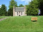 Upload another image | |||
| Scone Palace, Queen's Bridge Over Catmoor Burn | 56°25′14″N 3°25′56″W / 56.420598°N 3.432296°W / 56.420598; -3.432296 (Scone Palace, Queen's Bridge Over Catmoor Burn) | Category B | 18375 | Upload Photo | |||
| Bonhard House | 56°24′57″N 3°22′55″W / 56.415851°N 3.381916°W / 56.415851; -3.381916 (Bonhard House) | Category B | 18381 | Upload Photo | |||
| Colen, Steading | 56°27′26″N 3°26′51″W / 56.457332°N 3.447586°W / 56.457332; -3.447586 (Colen, Steading) | Category B | 18384 | Upload Photo | |||
| Waulkmill Ferry Bothy | 56°26′42″N 3°27′01″W / 56.444927°N 3.450391°W / 56.444927; -3.450391 (Waulkmill Ferry Bothy) | Category B | 18974 | Upload Photo | |||
| Hill House | 56°27′26″N 3°27′09″W / 56.457256°N 3.452548°W / 56.457256; -3.452548 (Hill House) | Category C(S) | 18356 | Upload Photo | |||
| Mediaeval Coffin And Other Fragments | 56°25′22″N 3°26′13″W / 56.422772°N 3.436998°W / 56.422772; -3.436998 (Mediaeval Coffin And Other Fragments) | Category B | 18373 | Upload Photo | |||
| Scone Palace Stables | 56°25′27″N 3°26′13″W / 56.424201°N 3.43702°W / 56.424201; -3.43702 (Scone Palace Stables) | Category B | 18376 | Upload Photo | |||
| Balboughty Steading | 56°25′56″N 3°25′17″W / 56.432127°N 3.421297°W / 56.432127; -3.421297 (Balboughty Steading) | Category B | 18377 | Upload Photo | |||
| Blairhall, Farmhouse | 56°26′22″N 3°26′07″W / 56.439353°N 3.435224°W / 56.439353; -3.435224 (Blairhall, Farmhouse) | Category B | 18379 | Upload Photo | |||
| Scone New Church Perth Road, New Scone | 56°25′13″N 3°23′53″W / 56.420326°N 3.397917°W / 56.420326; -3.397917 (Scone New Church Perth Road, New Scone) | Category B | 18363 | Upload Photo | |||
| 19 Lynedoch Road, New Scone | 56°25′24″N 3°24′01″W / 56.423272°N 3.40036°W / 56.423272; -3.40036 (19 Lynedoch Road, New Scone) | Category B | 18369 | Upload Photo | |||
| Balboughty House | 56°25′56″N 3°25′08″W / 56.432192°N 3.418802°W / 56.432192; -3.418802 (Balboughty House) | Category C(S) | 18378 | Upload Photo | |||
| Newmiln Cottages | 56°27′25″N 3°24′38″W / 56.456994°N 3.410607°W / 56.456994; -3.410607 (Newmiln Cottages) | Category C(S) | 48739 | Upload Photo | |||
| Parish Church, New Scone | 56°24′52″N 3°24′30″W / 56.414575°N 3.408307°W / 56.414575; -3.408307 (Parish Church, New Scone) | Category B | 18361 | Upload Photo | |||
| New Scone, Abbey Road, Robert Douglas Memorial Institute (Former School) And 22 Mansfield Road | 56°25′14″N 3°24′07″W / 56.420694°N 3.401935°W / 56.420694; -3.401935 (New Scone, Abbey Road, Robert Douglas Memorial Institute (Former School) And 22 Mansfield Road) | Category B | 18365 | Upload Photo | |||
| Scone Palace, Gateway And Boundary Wall Of Old Place | 56°25′25″N 3°26′08″W / 56.423733°N 3.435478°W / 56.423733; -3.435478 (Scone Palace, Gateway And Boundary Wall Of Old Place) | Category B | 18372 | Upload Photo | |||
| Newmiln, Gateway | 56°27′26″N 3°24′53″W / 56.457216°N 3.414818°W / 56.457216; -3.414818 (Newmiln, Gateway) | Category C(S) | 18357 | Upload Photo | |||
| Fairfield | 56°27′23″N 3°24′32″W / 56.456329°N 3.409008°W / 56.456329; -3.409008 (Fairfield) | Category B | 19875 | Upload Photo | |||
| Scone New Church Hall, Abbey Road, New Scone | 56°25′11″N 3°24′10″W / 56.419723°N 3.402791°W / 56.419723; -3.402791 (Scone New Church Hall, Abbey Road, New Scone) | Category C(S) | 18364 | Upload Photo | |||
| St. David's Chapel Stormontfield | 56°27′07″N 3°26′53″W / 56.451865°N 3.447962°W / 56.451865; -3.447962 (St. David's Chapel Stormontfield) | Category B | 18382 |  Upload another image | |||
| Colen, Farmhouse | 56°27′24″N 3°26′51″W / 56.456579°N 3.447395°W / 56.456579; -3.447395 (Colen, Farmhouse) | Category B | 18383 | Upload Photo | |||
| 12 Mansfield Road, New Scone | 56°25′13″N 3°24′00″W / 56.420212°N 3.400036°W / 56.420212; -3.400036 (12 Mansfield Road, New Scone) | Category C(S) | 18366 | Upload Photo | |||
| 20 Murrayshall Road, New Scone | 56°25′06″N 3°23′50″W / 56.418384°N 3.397213°W / 56.418384; -3.397213 (20 Murrayshall Road, New Scone) | Category B | 18368 | Upload Photo | |||
| Scone Palace, Bridge On Queen's Drive Over Catmoor Burn | 56°25′13″N 3°26′01″W / 56.420331°N 3.433696°W / 56.420331; -3.433696 (Scone Palace, Bridge On Queen's Drive Over Catmoor Burn) | Category B | 18374 | Upload Photo | |||
| Bonhard Doocot | 56°25′03″N 3°22′55″W / 56.417558°N 3.38188°W / 56.417558; -3.38188 (Bonhard Doocot) | Category B | 18380 | Upload Photo |
Key
The scheme for classifying buildings in Scotland is:
- Category A: "buildings of national or international importance, either architectural or historic; or fine, little-altered examples of some particular period, style or building type."[1]
- Category B: "buildings of regional or more than local importance; or major examples of some particular period, style or building type, which may have been altered."[1]
- Category C: "buildings of local importance; lesser examples of any period, style, or building type, as originally constructed or moderately altered; and simple traditional buildings which group well with other listed buildings."[1]
In March 2016 there were 47,288 listed buildings in Scotland. Of these, 8% were Category A, and 50% were Category B, with the remaining 42% being Category C.[2]
Notes
- ^ Sometimes known as OSGB36, the grid reference (where provided) is based on the British national grid reference system used by the Ordnance Survey.
• "Guide to National Grid". Ordnance Survey. Retrieved 12 December 2007.
• "Get-a-map". Ordnance Survey. Retrieved 17 December 2007. - ^ Historic Environment Scotland assign a unique alphanumeric identifier to each designated site in Scotland, for listed buildings this always begins with "LB", for example "LB12345".
References
- All entries, addresses and coordinates are based on data from Historic Scotland. This data falls under the Open Government Licence
- ^ a b c "What is Listing?". Historic Environment Scotland. Retrieved 29 May 2018.
- ^ Scotland's Historic Environment Audit 2016 (PDF). Historic Environment Scotland and the Built Environment Forum Scotland. pp. 15–16. Retrieved 29 May 2018.
- v
- t
- e
- Aberdalgie
- Aberfeldy
- Abernethy
- Abernyte
- Alyth
- Ardoch
- Arngask
- Auchterarder
- Auchtergaven
- Bendochy
- Blackford
- Blair Atholl
- Blairgowrie and Rattray
- Blairgowrie
- Caputh
- Cargill
- Cleish
- Clunie
- Collace
- Comrie
- Coupar Angus
- Crieff
- Dron
- Dull
- Dunbarney
- Dunkeld and Dowally
- Dunning
- Errol
- Findo Gask
- Forgandenny
- Forteviot
- Fortingall
- Fossoway
- Fowlis Wester
- Glendevon
- Inchture
- Kenmore
- Kettins
- Kilspindie
- Kinclaven
- Kinfauns
- Kinloch
- Kinnaird
- Kinnoull
- Kinross
- Kirkmichael
- Lethendy
- Liff and Benvie
- Little Dunkeld
- Logiealmond
- Logierait
- Longforgan
- Madderty
- Meigle
- Methven
- Moneydie
- Monzievaird and Strowan
- Moulin
- Muckhart
- Muthill
- Orwell
- Perth
- Pitlochry
- Portmoak
- Rattray
- Redgorton
- Rhynd
- Scone
- St Madoes
- St Martins
- Tibbermore
- Trinity Gask
- Weem


