List of listed buildings in Kinross, Perth and Kinross
This is a list of listed buildings in the parish of Kinross in Perth and Kinross, Scotland.
Map all coordinates using OpenStreetMap
Download coordinates as:
- KML
- GPX (all coordinates)
- GPX (primary coordinates)
- GPX (secondary coordinates)
List
| Name | Location | Date Listed | Grid Ref. [note 1] | Geo-coordinates | Notes | LB Number [note 2] | Image |
|---|---|---|---|---|---|---|---|
| Kirkland's Hotel 20 High Street | 56°12′21″N 3°25′20″W / 56.205885°N 3.422216°W / 56.205885; -3.422216 (Kirkland's Hotel 20 High Street) | Category B | 36284 |  Upload Photo | |||
| Clydesdale Bank 37 High Street | 56°12′22″N 3°25′17″W / 56.206075°N 3.421337°W / 56.206075; -3.421337 (Clydesdale Bank 37 High Street) | Category B | 36289 | Upload Photo | |||
| Salutation Inn, 99 High Street | 56°12′15″N 3°25′15″W / 56.20424°N 3.420721°W / 56.20424; -3.420721 (Salutation Inn, 99 High Street) | Category B | 36290 | Upload Photo | |||
| 3 And 5 School Wynd | 56°12′13″N 3°25′18″W / 56.203727°N 3.421556°W / 56.203727; -3.421556 (3 And 5 School Wynd) | Category B | 36292 | Upload Photo | |||
| 108 High Street (Old Post Office) | 56°12′11″N 3°25′16″W / 56.203111°N 3.421227°W / 56.203111; -3.421227 (108 High Street (Old Post Office)) | Category B | 36298 | Upload Photo | |||
| Kinross House | 56°12′11″N 3°24′35″W / 56.202946°N 3.40976°W / 56.202946; -3.40976 (Kinross House) | Category A | 11200 |  Upload another image | |||
| Victoria Bar 121-123 High Street | 56°12′11″N 3°25′14″W / 56.203136°N 3.420648°W / 56.203136; -3.420648 (Victoria Bar 121-123 High Street) | Category C(S) | 36301 | Upload Photo | |||
| Old Red Lion Inn (Annexe To Victoria Bar) | 56°12′11″N 3°25′14″W / 56.203002°N 3.420562°W / 56.203002; -3.420562 (Old Red Lion Inn (Annexe To Victoria Bar)) | Category C(S) | 36302 | Upload Photo | |||
| 11, 13 School Wynd | 56°12′13″N 3°25′19″W / 56.203705°N 3.421974°W / 56.203705; -3.421974 (11, 13 School Wynd) | Category C(S) | 36307 | Upload Photo | |||
| Lethangie Estate, Stable Block | 56°13′11″N 3°24′48″W / 56.219753°N 3.41336°W / 56.219753; -3.41336 (Lethangie Estate, Stable Block) | Category B | 12965 | Upload Photo | |||
| Kinross Stables | 56°12′16″N 3°24′48″W / 56.204432°N 3.413377°W / 56.204432; -3.413377 (Kinross Stables) | Category B | 11201 | Upload Photo | |||
| 49 Muirs, The Muirs Inn Including Gatepiers And Boundary Walls | 56°12′40″N 3°25′30″W / 56.211111°N 3.424893°W / 56.211111; -3.424893 (49 Muirs, The Muirs Inn Including Gatepiers And Boundary Walls) | Category C(S) | 47316 |  Upload another image | |||
| Turfhills House | 56°12′34″N 3°26′35″W / 56.209524°N 3.443182°W / 56.209524; -3.443182 (Turfhills House) | Category B | 43207 | Upload Photo | |||
| Kinross West, Church Of Scotland, (Kinross Parish Kirk) Station Road | 56°12′20″N 3°25′25″W / 56.205429°N 3.423602°W / 56.205429; -3.423602 (Kinross West, Church Of Scotland, (Kinross Parish Kirk) Station Road) | Category B | 36283 | Upload Photo | |||
| 'Mossgrove', 18 Muirs | 56°12′35″N 3°25′31″W / 56.209714°N 3.42526°W / 56.209714; -3.42526 ('Mossgrove', 18 Muirs) | Category B | 36287 | Upload Photo | |||
| Gates And Lodges At Entrance To Kinross House Policies. Avenue Road | 56°12′15″N 3°25′11″W / 56.204154°N 3.419621°W / 56.204154; -3.419621 (Gates And Lodges At Entrance To Kinross House Policies. Avenue Road) | Category B | 36291 | Upload Photo | |||
| Loch Leven Inn 6 Swan's Acre | 56°12′15″N 3°25′17″W / 56.204069°N 3.42152°W / 56.204069; -3.42152 (Loch Leven Inn 6 Swan's Acre) | Category C(S) | 36294 | Upload Photo | |||
| Burnbrae Farmhouse, Dairy And Walled Garden | 56°12′46″N 3°28′58″W / 56.212892°N 3.482796°W / 56.212892; -3.482796 (Burnbrae Farmhouse, Dairy And Walled Garden) | Category B | 13325 | Upload Photo | |||
| County Buildings 21-25 High Street | 56°12′24″N 3°25′18″W / 56.20653°N 3.421611°W / 56.20653; -3.421611 (County Buildings 21-25 High Street) | Category B | 36288 |  Upload another image | |||
| 8 School Wynd And 5 Swan's Acre (Tighnuilt) | 56°12′14″N 3°25′19″W / 56.203939°N 3.421886°W / 56.203939; -3.421886 (8 School Wynd And 5 Swan's Acre (Tighnuilt)) | Category C(S) | 36293 | Upload Photo | |||
| 98, 100, 102 High Street | 56°12′12″N 3°25′16″W / 56.203444°N 3.421207°W / 56.203444; -3.421207 (98, 100, 102 High Street) | Category B | 36295 | Upload Photo | |||
| 7, 9, School Wynd | 56°12′13″N 3°25′18″W / 56.203716°N 3.421781°W / 56.203716; -3.421781 (7, 9, School Wynd) | Category C(S) | 36306 | Upload Photo | |||
| 10 Brewery Lane | 56°12′13″N 3°25′20″W / 56.20373°N 3.42212°W / 56.20373; -3.42212 (10 Brewery Lane) | Category C(S) | 36308 | Upload Photo | |||
| Lethangie House With Garden Walls And Gazebo To West, And Summerhouse To East | 56°13′10″N 3°24′57″W / 56.219554°N 3.415804°W / 56.219554; -3.415804 (Lethangie House With Garden Walls And Gazebo To West, And Summerhouse To East) | Category B | 12961 | Upload Photo | |||
| Watch Tower, East Burial Ground | 56°12′03″N 3°24′24″W / 56.20078°N 3.406634°W / 56.20078; -3.406634 (Watch Tower, East Burial Ground) | Category C(S) | 11198 | Upload Photo | |||
| Municipal Chambers 18 High Street | 56°12′22″N 3°25′20″W / 56.205984°N 3.422252°W / 56.205984; -3.422252 (Municipal Chambers 18 High Street) | Category B | 36285 | Upload Photo | |||
| The Bank House, Former British Linen Bank, 2 High Street | 56°12′28″N 3°25′26″W / 56.207826°N 3.423804°W / 56.207826; -3.423804 (The Bank House, Former British Linen Bank, 2 High Street) | Category B | 36286 | Upload Photo | |||
| Old Manse, 8 Sandport | 56°12′04″N 3°25′15″W / 56.201057°N 3.420958°W / 56.201057; -3.420958 (Old Manse, 8 Sandport) | Category B | 36304 | Upload Photo | |||
| Mercat Cross Sandport | 56°12′05″N 3°25′17″W / 56.201268°N 3.421336°W / 56.201268; -3.421336 (Mercat Cross Sandport) | Category B | 36305 | Upload Photo | |||
| Lethangie Estate, South Lodge Including Gatepiers | 56°13′07″N 3°24′54″W / 56.218495°N 3.414927°W / 56.218495; -3.414927 (Lethangie Estate, South Lodge Including Gatepiers) | Category B | 12962 | Upload Photo | |||
| Annacroich Farm-House | 56°10′20″N 3°25′32″W / 56.172323°N 3.425485°W / 56.172323; -3.425485 (Annacroich Farm-House) | Category B | 11203 | Upload Photo | |||
| Fountain, High Street | 56°12′12″N 3°25′16″W / 56.203284°N 3.421024°W / 56.203284; -3.421024 (Fountain, High Street) | Category C(S) | 36296 | 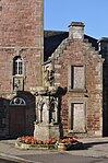 Upload another image | |||
| The Clock Tower, High Street | 56°12′12″N 3°25′16″W / 56.203202°N 3.421182°W / 56.203202; -3.421182 (The Clock Tower, High Street) | Category B | 36297 | 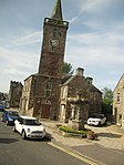 Upload another image | |||
| 110 High Street, Former Town Hall | 56°12′11″N 3°25′17″W / 56.203039°N 3.421289°W / 56.203039; -3.421289 (110 High Street, Former Town Hall) | Category B | 36299 |  Upload another image | |||
| Lethangie Estate, Farmbuildings To E Of House | 56°13′09″N 3°24′49″W / 56.219283°N 3.413585°W / 56.219283; -3.413585 (Lethangie Estate, Farmbuildings To E Of House) | Category B | 12964 | Upload Photo | |||
| Balado Bridge | 56°12′28″N 3°27′29″W / 56.207821°N 3.458159°W / 56.207821; -3.458159 (Balado Bridge) | Category B | 11202 | Upload Photo | |||
| The Muirs, St Paul's Episcopal Church Including Boundary Walls And Piers | 56°12′41″N 3°25′30″W / 56.211443°N 3.424921°W / 56.211443; -3.424921 (The Muirs, St Paul's Episcopal Church Including Boundary Walls And Piers) | Category B | 48623 | Upload Photo | |||
| 112 High Street, Carnegie Public Library | 56°12′10″N 3°25′17″W / 56.202876°N 3.421379°W / 56.202876; -3.421379 (112 High Street, Carnegie Public Library) | Category C(S) | 48649 | Upload Photo | |||
| Old County Building 109-113 High Street | 56°12′12″N 3°25′15″W / 56.203459°N 3.420708°W / 56.203459; -3.420708 (Old County Building 109-113 High Street) | Category B | 36300 |  Upload another image | |||
| Lethangie Estate, Walled Kitchen Garden, Dovecote And Outbuildings | 56°13′09″N 3°24′45″W / 56.219132°N 3.412579°W / 56.219132; -3.412579 (Lethangie Estate, Walled Kitchen Garden, Dovecote And Outbuildings) | Category B | 12966 | Upload Photo | |||
| Lochleven Castle Castle Island Loch Leven | 56°12′03″N 3°23′30″W / 56.20076°N 3.391787°W / 56.20076; -3.391787 (Lochleven Castle Castle Island Loch Leven) | Category A | 11199 | 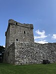 Upload another image | |||
| Church Hall (Old East U.P. Church) | 56°12′12″N 3°25′12″W / 56.203323°N 3.419977°W / 56.203323; -3.419977 (Church Hall (Old East U.P. Church)) | Category C(S) | 36303 | Upload Photo | |||
| 12 Brewery Lane | 56°12′13″N 3°25′20″W / 56.203711°N 3.422216°W / 56.203711; -3.422216 (12 Brewery Lane) | Category C(S) | 36309 | Upload Photo | |||
| Lethangie Estate, West Lodge Including Gatepiers | 56°13′12″N 3°25′30″W / 56.220104°N 3.424985°W / 56.220104; -3.424985 (Lethangie Estate, West Lodge Including Gatepiers) | Category B | 12963 | Upload Photo | |||
| Bruce Mortuary Chapel, East Burial Ground | 56°12′03″N 3°24′23″W / 56.200926°N 3.406413°W / 56.200926; -3.406413 (Bruce Mortuary Chapel, East Burial Ground) | Category C(S) | 11197 | Upload Photo |
Key
The scheme for classifying buildings in Scotland is:
- Category A: "buildings of national or international importance, either architectural or historic; or fine, little-altered examples of some particular period, style or building type."[1]
- Category B: "buildings of regional or more than local importance; or major examples of some particular period, style or building type, which may have been altered."[1]
- Category C: "buildings of local importance; lesser examples of any period, style, or building type, as originally constructed or moderately altered; and simple traditional buildings which group well with other listed buildings."[1]
In March 2016 there were 47,288 listed buildings in Scotland. Of these, 8% were Category A, and 50% were Category B, with the remaining 42% being Category C.[2]
Notes
- ^ Sometimes known as OSGB36, the grid reference (where provided) is based on the British national grid reference system used by the Ordnance Survey.
• "Guide to National Grid". Ordnance Survey. Retrieved 12 December 2007.
• "Get-a-map". Ordnance Survey. Retrieved 17 December 2007. - ^ Historic Environment Scotland assign a unique alphanumeric identifier to each designated site in Scotland, for listed buildings this always begins with "LB", for example "LB12345".
References
- All entries, addresses and coordinates are based on data from Historic Scotland. This data falls under the Open Government Licence
- ^ a b c "What is Listing?". Historic Environment Scotland. Retrieved 29 May 2018.
- ^ Scotland's Historic Environment Audit 2016 (PDF). Historic Environment Scotland and the Built Environment Forum Scotland. pp. 15–16. Retrieved 29 May 2018.
- v
- t
- e
- Aberdalgie
- Aberfeldy
- Abernethy
- Abernyte
- Alyth
- Ardoch
- Arngask
- Auchterarder
- Auchtergaven
- Bendochy
- Blackford
- Blair Atholl
- Blairgowrie and Rattray
- Blairgowrie
- Caputh
- Cargill
- Cleish
- Clunie
- Collace
- Comrie
- Coupar Angus
- Crieff
- Dron
- Dull
- Dunbarney
- Dunkeld and Dowally
- Dunning
- Errol
- Findo Gask
- Forgandenny
- Forteviot
- Fortingall
- Fossoway
- Fowlis Wester
- Glendevon
- Inchture
- Kenmore
- Kettins
- Kilspindie
- Kinclaven
- Kinfauns
- Kinloch
- Kinnaird
- Kinnoull
- Kinross
- Kirkmichael
- Lethendy
- Liff and Benvie
- Little Dunkeld
- Logiealmond
- Logierait
- Longforgan
- Madderty
- Meigle
- Methven
- Moneydie
- Monzievaird and Strowan
- Moulin
- Muckhart
- Muthill
- Orwell
- Perth
- Pitlochry
- Portmoak
- Rattray
- Redgorton
- Rhynd
- Scone
- St Madoes
- St Martins
- Tibbermore
- Trinity Gask
- Weem


