Gulf of Tadjoura
Gulf of the Indian Ocean in the Horn of Africa
11°42′N 43°00′E / 11.7°N 43.0°E / 11.7; 43.0 Djibouti
 Somaliland Djibouti: Djibouti, Tadjoura, Sagallo, Obock and Loyada Somaliland: Lawyacado
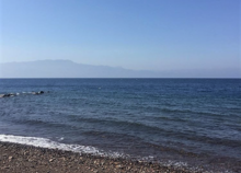
The Gulf of Tadjoura (Somali: Gacanka Tajuura; Arabic: خليج تدجورا) is a gulf or basin of the Indian Ocean in the Horn of Africa. It lies south of the straits of Bab-el-Mandeb, or the entrance to the Red Sea, at 11°42′N 43°00′E / 11.7°N 43.0°E / 11.7; 43.0. The gulf has many fishing grounds, extensive coral reefs, and abundant pearl oysters. Most of its coastline is the territory of Djibouti, except for a short stretch on the southern shore, which is part of the territory of Somaliland.
The Gulf’s other marine habitats include sea grass beds, salt pans and mangroves.
History
In August 1840, the conclusion of a treaty of friendship and commerce between the Sultan Mohammed bin Mohammed of Tadjoura and Commander Robert Moresby of the Indian Navy is tracking the sale of Moucha Island to Great Britain for ten sacks of rice. The sale will however follow any occupation. In 1887, Britain cedes sovereignty of the island to France at the same time it recognizes the French sphere of influence in the Gulf of Tadjoura, in exchange for the abandonment by France of any right in Zeila and the neighboring islands.
Geography
The area of the gulf is 347 km2 (900 sq mi). The length (from the Sagallo to Obock) is 64 km (40 mi) and the width varies from 26 km (16 mi).The gulf is relatively shallow with the depth decreasing from the entrance to the gulf to the continent. The coast is mostly sloping; there are abundant sandy dunes, with occasional palm trees. The southern shores are smooth and shallow.
At the entrance of the Gulf is the group of small islands of Moucha and Maskali. At the bottom of the Gulf, separated only by a narrow neck of land, Ghoubbet-el-Kharab and Assal (54 km2). Geologically, formerly covered the Gulf to Lake Assal, which is now about 155 meters below sea level
Limits
The limits of the Gulf of Tadjoura as follows:
- On the East – The western limit of the Gulf of Aden (A line joining Obock and Lawyacado).
- On the West – The meridian of Ghoubbet-el-Kharab.
Islands
The Gulf of Tadjoura is home to many small islands. Geographically the biggest island in the Gulf of Tadjoura is Moucha Island. The Gulf of Tadjoura islands are often also historically significant, having been used in the past by colonial powers such as the French and the British in their trade or as acquisitions for their empires.
Wildlife
The wildlife of the Gulf of Tadjoura is diverse, and entirely unique due to the gulf's geographic distribution. The Gulf of Tadjoura has hosted some of the most magnificent marine fauna and flora, some of which are near extinction or at serious environmental risk. From corals, to dugongs, Gulf of Tadjoura is a diverse cradle for many species who depend on each other for survival.
Population

The Gulf of Tadjoura is far more densely populated on the Djiboutian shore. The most significant towns and cities along both the Djiboutian and Somali sides of the Gulf of Tadjoura
Djibouti
- Djibouti City: 529,000
- Tadjoura: 45,000
- Obock: 21,000
- Loyada: 1,367
- Sagallo: 719
Somaliland
- Lawyacado: 1,650
Tourism
The Gulf of Tadjoura is one of the major tourist attractions for Djibouti, believed to be a perfect place for snorkelling with whale sharks, diving and underwater photography. There are two important towns on the gulf: Obock, where Afar and Somali sultans had sold settlement rights to the French, and Tadjoura, which houses seven important mosques and offers magnificent views from the sea.
Tadjoura is beautifully surrounded by the green Goda Mountains. The hills of this mountain are 1,700 metres (5,600 ft).[clarification needed] Due to coral reefs, the Gulf of Tadjoura is a heaven for divers and snorkelers. It attracts 40% of foreign tourists visiting Djibouti.
Economy
Passenger transport on the gulf includes a number of ferry lines which connect the following ports: Djibouti City, Tadjoura and Obock.
External links
 Media related to Gulf of Tadjoura at Wikimedia Commons
- v
- t
- e
African seas
and seas
and bays
- Abu Qir Bay
- Acheïl Dakhlet
- Al Hoceima Bay
- Algiers Bay
- Algoa Bay
- Ambas Bay
- Ana Chaves Bay
- Angra de Cintra
- Antongil Bay
- Antsiranana Bay
- Arab's Gulf
- Baía Almeida
- Baía da Condúcia
- Baía da Corimba
- Baía de Mocambo
- Baía de Mossuril
- Baía de Namibe
- Baia de Porto Amboim
- Baía de Santa Marta
- Baía de Sucujaque
- Baía de Tombua
- Baía do Ambriz
- Baía do Bengo
- Baía do Dande
- Baía do Govuro
- Baía do Lúrio
- Baía do Nzeto
- Baía do Suto
- Baie de Gorée
- Baie de Sangareya
- Bandombaai
- Bay of Anfile
- Bay of Arguin
- Bay of Arzew
- Bay of Aseb
- Bay of Beylul
- Bay of Edd
- Bay of Hawakil
- Bay of Langarano
- Bay of Saint-Augustin
- Bay of Tangier
- Benguela Bay
- Bera’esoli
- Betty’s Bay
- Bight of Benin
- Bight of Biafra
- Bocock’s Bay
- Bombetoka Bay
- Bootbaai
- Bosluisbaai
- Cabinda Bay
- Cape Cross Bay
- Cape Negro Bay
- Chake-Chake Bay
- Chameis Bay
- Chwaka Bay
- Conception Bay
- Cuio Bay
- Dakhlet Nouadhibou
- Dalwakteah Bay
- Deurloopbaai
- Doringbaai
- Dungonab Bay
- Durissa Bay
- Elands Bay
- Enseada das Pombas
- Enseada de São Braz
- Enseada do Catumbo
- Enseada do Chalungo
- Enseada do Quicombo
- Enseada do Quitungo
- Enseada dos Três Irmãos
- Equimina Bay
- False Bay
- Farta Bay
- Fernao Veloso Bay
- Foul Bay
- Frederik se Baai
- Ghoubbet-el-Kharab
- Grosse Bucht
- Gulf of Aden
- Gulf of 'Agig
- Gulf of Gabès
- Gulf of Guinea
- Gulf of Hammamet
- Gulf of Sidra
- Gulf of Suez
- Gulf of Tadjoura
- Gulf of Tunis
- Gulf of Zula
- Hafun Bay South
- Hann Bay
- Harrison Cove
- Henties Bay
- Hirghīgo Bahir Selat’ē
- Horingbaai
- Hottentotsbaai
- Hurdiyo
- Hydra Bay
- Inhambane Bay
- Jammer Bucht
- John Owen Bay
- Kalawy Bay
- Kiwaiyu Bay
- Lambert Bay
- Lamu Bay
- Langbaai
- Loango Bay
- Lobito Bay
- Luanda Bay
- Lüderitz Bay
- McDougall Bay
- Manza Bay
- Maputo Bay
- Markusbaai
- Memba Bay
- Menai Bay
- Meob Bay
- Mietjie Frans se Baai
- Moraha Bahir Selat’ē
- Mossel Bay
- Möwebaai
- Noopbaai
- Oran Gulf
- Pemba Bay
- Pipas Bay
- Plaatjieskraalbaai
- Platbaai
- Plettenbergbaai
- Pointe-Noire Bay
- Porto Alexandre, Angola
- Prinzen Bucht
- Río de Oro Bay
- Rock Bay
- Roode Bay
- Rooiwalbaai
- Saint Francis Bay
- Saint Francis Bay (Eastern Cape)
- St Helena Bay
- Saint Sebastian Bay
- Saldanha Bay
- Sandwich Harbour
- Sierra Bay
- Skoonbergbaai
- Skurfbaai
- Slangbaai
- Sodwana Bay
- Sofala Bay
- Somnaasbaai
- Spencer Bay
- Spoegrivierbaai
- Struisbaai
- Swartstraat
- Table Bay
- Thysbaai
- Tietiesbaai
- Ungama Bay
- Walker Bay
- Walvis Bay (bay)
- Yawri Bay
- Yof Bay
- Bab-el-Mandeb
- Bab Iskender
- Canal de Bolama
- Canal de Bolola
- Canal de Caió
- Canal de São Vicente
- Canal do Meio
- Guardafui Channel
- Mafia Channel
- Massawa Channel
- Mozambique Channel
- Pemba Channel
- Shubuk Channel
- Strait of Gibraltar
- Strait of Sicily
- Straits of Tiran
- Tigres Strait
- Zanzibar Channel
seas
 Africa portal
  Oceans portal
Authority control databases | |
|---|---|
| International |
|
| National |
|


