Dakhlet Nouadhibou
20°52′N 16°54′W / 20.87°N 16.9°W / 20.87; -16.9Ocean/sea sources Atlantic Ocean[1] Basin countries Mauritania Max. length 54 km (34 mi) Max. width 32 km (20 mi) 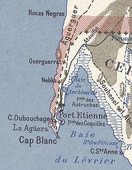
1958 French map of the Dakhlet Nouadhibou bay area 
Ships graveyard, Nouadhibou, Mauritania Oceans
and seas Gulfs
and bays Straits Historical
seas  Africa portal
  Oceans portal
Dakhlet Nouadhibou is a bay on the Atlantic shore of Mauritania.[2] The Dakhlet Nouadhibou Region, one of the primary administrative divisions of Mauritania, is named after it.
Geography
It is one of the largest natural ports on the Atlantic coast of Africa and the only one in Mauritania. It is limited by the Cap Blanc (also known as Ras Nouadhibou ) headland on its western side.[2] The bay opens towards the south and contains numerous shoals and extends from north to south for about 50 km, creating a bay about 43 km long and 32 km wide at the widest point. In French maps the inner bay is known as Baie de l'Archimède and the wider bay as Baie du Lévrier.[3]
In addition to its geographical conditions, the bay of Nouadhibou has very favourable maritime conditions, given the absence of significant currents. The weather conditions also favour its use as a port as it is sheltered from winds and storms. The only unfavourable factor is the shallow sea depth in most of the bay, which has required frequent drainage of the navigation channels.

Economical importance
The bay of Nouadhibou is the most important economic and commercial area of Mauritania. It is the base of the Mauritanian fishing industry, as well as the route by which the iron ore from the mines of Zouérat is exported from the country. The iron ore arrives at the ore terminal of Point Central (located 10 kilometers south of Nouadhibou) by a railway which runs 650 km from the mines to the port.
The Bay of Nouadhibou is the final resting place of over 300 ships and one of the world's largest ship graveyards.[4][5]

See also
- French cruiser Chasseloup-Laubat
References
- ^ GoogleEarth
- ^ a b "Dakhlet Nouadhibou". Mapcarta. Retrieved 18 October 2016.
- ^ Pazzanita, Anthony G. (2008). "Dakhlet Nouadhibou". Historical dictionary of Mauritania. Scarecrow Press. ISBN 978-0-8108-5596-0.
- ^ "Largest Ship Graveyard in the World: Nouadhibou, Mauritania". Sometimes Interesting. 2013-07-25. Retrieved 2020-05-30.
- ^ Sebe, Berny (2007). "Nouadhibou's rusty legacy" (PDF). Ship Management International. 7: 82–84.[permanent dead link]
- v
- t
- e
African seas
and seas
- Alboran Sea
- Atlantic Ocean
- Indian Ocean
- Levantine Sea
- Mediterranean Sea
- Red Sea
- Southern Ocean
and bays
- Abu Qir Bay
- Acheïl Dakhlet
- Al Hoceima Bay
- Algiers Bay
- Algoa Bay
- Ambas Bay
- Ana Chaves Bay
- Angra de Cintra
- Antongil Bay
- Antsiranana Bay
- Arab's Gulf
- Baía Almeida
- Baía da Condúcia
- Baía da Corimba
- Baía de Mocambo
- Baía de Mossuril
- Baía de Namibe
- Baia de Porto Amboim
- Baía de Santa Marta
- Baía de Sucujaque
- Baía de Tombua
- Baía do Ambriz
- Baía do Bengo
- Baía do Dande
- Baía do Govuro
- Baía do Lúrio
- Baía do Nzeto
- Baía do Suto
- Baie de Gorée
- Baie de Sangareya
- Bandombaai
- Bay of Anfile
- Bay of Arguin
- Bay of Arzew
- Bay of Aseb
- Bay of Beylul
- Bay of Edd
- Bay of Hawakil
- Bay of Langarano
- Bay of Saint-Augustin
- Bay of Tangier
- Benguela Bay
- Bera’esoli
- Betty’s Bay
- Bight of Benin
- Bight of Biafra
- Bocock’s Bay
- Bombetoka Bay
- Bootbaai
- Bosluisbaai
- Cabinda Bay
- Cape Cross Bay
- Cape Negro Bay
- Chake-Chake Bay
- Chameis Bay
- Chwaka Bay
- Conception Bay
- Cuio Bay
- Dakhlet Nouadhibou
- Dalwakteah Bay
- Deurloopbaai
- Doringbaai
- Dungonab Bay
- Durissa Bay
- Elands Bay
- Enseada das Pombas
- Enseada de São Braz
- Enseada do Catumbo
- Enseada do Chalungo
- Enseada do Quicombo
- Enseada do Quitungo
- Enseada dos Três Irmãos
- Equimina Bay
- False Bay
- Farta Bay
- Fernao Veloso Bay
- Foul Bay
- Frederik se Baai
- Ghoubbet-el-Kharab
- Grosse Bucht
- Gulf of Aden
- Gulf of 'Agig
- Gulf of Gabès
- Gulf of Guinea
- Gulf of Hammamet
- Gulf of Sidra
- Gulf of Suez
- Gulf of Tadjoura
- Gulf of Tunis
- Gulf of Zula
- Hafun Bay South
- Hann Bay
- Harrison Cove
- Henties Bay
- Hirghīgo Bahir Selat’ē
- Horingbaai
- Hottentotsbaai
- Hurdiyo
- Hydra Bay
- Inhambane Bay
- Jammer Bucht
- John Owen Bay
- Kalawy Bay
- Kiwaiyu Bay
- Lambert Bay
- Lamu Bay
- Langbaai
- Loango Bay
- Lobito Bay
- Luanda Bay
- Lüderitz Bay
- McDougall Bay
- Manza Bay
- Maputo Bay
- Markusbaai
- Memba Bay
- Menai Bay
- Meob Bay
- Mietjie Frans se Baai
- Moraha Bahir Selat’ē
- Mossel Bay
- Möwebaai
- Noopbaai
- Oran Gulf
- Pemba Bay
- Pipas Bay
- Plaatjieskraalbaai
- Platbaai
- Plettenbergbaai
- Pointe-Noire Bay
- Porto Alexandre, Angola
- Prinzen Bucht
- Río de Oro Bay
- Rock Bay
- Roode Bay
- Rooiwalbaai
- Saint Francis Bay
- Saint Francis Bay (Eastern Cape)
- St Helena Bay
- Saint Sebastian Bay
- Saldanha Bay
- Sandwich Harbour
- Sierra Bay
- Skoonbergbaai
- Skurfbaai
- Slangbaai
- Sodwana Bay
- Sofala Bay
- Somnaasbaai
- Spencer Bay
- Spoegrivierbaai
- Struisbaai
- Swartstraat
- Table Bay
- Thysbaai
- Tietiesbaai
- Ungama Bay
- Walker Bay
- Walvis Bay (bay)
- Yawri Bay
- Yof Bay
- Bab-el-Mandeb
- Bab Iskender
- Canal de Bolama
- Canal de Bolola
- Canal de Caió
- Canal de São Vicente
- Canal do Meio
- Guardafui Channel
- Mafia Channel
- Massawa Channel
- Mozambique Channel
- Pemba Channel
- Shubuk Channel
- Strait of Gibraltar
- Strait of Sicily
- Straits of Tiran
- Tigres Strait
- Zanzibar Channel
seas
 Africa portal
  Oceans portal
 | This Mauritania location article is a stub. You can help Wikipedia by expanding it. |
- v
- t
- e


