Grade I listed buildings in North Kesteven
Map all coordinates using OpenStreetMap
Download coordinates as:
- KML
- GPX (all coordinates)
- GPX (primary coordinates)
- GPX (secondary coordinates)
There are over 9,000 Grade I listed buildings in England. This page is a list of these buildings in the district of North Kesteven in Lincolnshire.
North Kesteven
| Name | Location | Type | Completed [note 1] | Date designated | Grid ref.[note 2] Geo-coordinates | Entry number [note 3] | Image |
|---|---|---|---|---|---|---|---|
| Church of St Edith | Anwick | Parish Church | Late 13th century | 1 February 1967 | TF1145150634 53°02′29″N 0°20′21″W / 53.041373°N 0.339134°W / 53.041373; -0.339134 (Church of St Edith) | 1061829 |  More images |
| Church of St Andrew | Asgarby, Asgarby and Howell | Parish Church | 13th century | 1 February 1967 | TF1162745389 52°59′39″N 0°20′18″W / 52.994208°N 0.338322°W / 52.994208; -0.338322 (Church of St Andrew) | 1061832 | 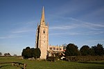 More images |
| Church of St Mary | Bloxholm, Ashby De La Launde and Bloxholm | Parish Church | c. 1300 | 7 December 1987 | TF0646153776 53°04′14″N 0°24′45″W / 53.070621°N 0.412492°W / 53.070621; -0.412492 (Church of St Mary) | 1261473 |  More images |
| Parish Church of St Denys | Aswarby and Swarby | Church | 12th century | 1 February 1967 | TF0672039906 52°56′45″N 0°24′48″W / 52.945938°N 0.413205°W / 52.945938; -0.413205 (Parish Church of St Denys) | 1360619 |  More images |
| Aubourn Hall | Aubourn Haddington and South Hykeham | Country House | 16th century | 22 December 1983 | SK9265462853 53°09′17″N 0°36′57″W / 53.15476°N 0.615878°W / 53.15476; -0.615878 (Aubourn Hall) | 1061955 |  More images |
| Church of All Saints | Beckingham | Parish Church | 12th century | 23 August 1967 | SK8756553797 53°04′27″N 0°41′40″W / 53.074237°N 0.694425°W / 53.074237; -0.694425 (Church of All Saints) | 1360525 |  More images |
| Church of St Michael | Billinghay | Boiler House | C20 | 1 February 1967 | TF1568154937 53°04′45″N 0°16′28″W / 53.079138°N 0.274529°W / 53.079138; -0.274529 (Church of St Michael) | 1204770 |  More images |
| Orchard Outbuilding at Somerton Castle | Boothby Graffoe | Tower | 14th century | 23 August 1967 | SK9546058828 53°07′05″N 0°34′30″W / 53.118096°N 0.575127°W / 53.118096; -0.575127 (Orchard Outbuilding at Somerton Castle) | 1360511 |  Upload Photo |
| Somerton Castle and Outbuilding to North-west | Boothby Graffoe | Farmhouse | 19th century | 23 August 1967 | SK9543158760 53°07′03″N 0°34′32″W / 53.11749°N 0.57558°W / 53.11749; -0.57558 (Somerton Castle and Outbuilding to North-west) | 1061974 |  More images |
| South-west Outbuilding at Somerton Castle | Boothby Graffoe | Tower | 14th century | 23 August 1967 | SK9538558759 53°07′03″N 0°34′35″W / 53.117489°N 0.576268°W / 53.117489; -0.576268 (South-west Outbuilding at Somerton Castle) | 1061975 | Upload Photo |
| Church of St Helen | Brant Broughton, Brant Broughton and Stragglethorpe | Parish Church | 11th century | 23 August 1967 | SK9154453899 53°04′28″N 0°38′06″W / 53.074487°N 0.635022°W / 53.074487; -0.635022 (Church of St Helen) | 1147497 | 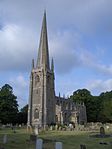 More images |
| Church of St Michael | Stragglethorpe, Brant Broughton and Stragglethorpe | Parish Church | 11th century | 23 August 1967 | SK9133752416 53°03′40″N 0°38′19″W / 53.061196°N 0.638532°W / 53.061196; -0.638532 (Church of St Michael) | 1061900 |  More images |
| Church of All Saints | Canwick | Parish Church | 12th century | 23 August 1967 | SK9874569700 53°12′55″N 0°31′22″W / 53.215194°N 0.52271°W / 53.215194; -0.52271 (Church of All Saints) | 1205100 |  More images |
| Church of Saint Mary | Carlton-le-Moorland | Parish Church | 11th century | 23 August 1967 | SK9080957895 53°06′38″N 0°38′42″W / 53.110523°N 0.644862°W / 53.110523; -0.644862 (Church of Saint Mary) | 1360553 |  More images |
| Church of All Saints | Coleby | Parish Church | Saxon | 23 August 1967 | SK9752060589 53°08′01″N 0°32′38″W / 53.133548°N 0.543823°W / 53.133548; -0.543823 (Church of All Saints) | 1164829 | 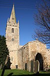 More images |
| The Temple at Coleby Hall | Coleby | Garden Temple | 1762 | 19 November 1951 | SK9750860936 53°08′12″N 0°32′38″W / 53.136669°N 0.543897°W / 53.136669; -0.543897 (The Temple at Coleby Hall) | 1360515 | Upload Photo |
| Church of St Andrew | Cranwell, Cranwell and Byard's Leap | Parish Church | 11th century | 1 February 1967 | TF0327749975 53°02′14″N 0°27′40″W / 53.03709°N 0.461212°W / 53.03709; -0.461212 (Church of St Andrew) | 1254166 | 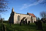 More images |
| Culverthorpe Hall | Culverthorpe, Culverthorpe and Kelby | Country House | Late 17th century | 23 November 1951 | TF0201540374 52°57′04″N 0°28′59″W / 52.951057°N 0.483052°W / 52.951057; -0.483052 (Culverthorpe Hall) | 1061793 |  More images |
| Parish Church of St Andrew | Kelby, Culverthorpe and Kelby | Church | 12th century | 1 February 1967 | TF0035941424 52°57′39″N 0°30′27″W / 52.960805°N 0.507366°W / 52.960805; -0.507366 (Parish Church of St Andrew) | 1360583 |  More images |
| Church of St Thomas a Becket | Digby | Parish Church | 11th century | 1 February 1967 | TF0805054815 53°04′47″N 0°23′18″W / 53.079638°N 0.388437°W / 53.079638; -0.388437 (Church of St Thomas a Becket) | 1254176 | 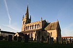 More images |
| Church of St Peter | Doddington, Doddington and Whisby | Parish Church | 13th century | 23 August 1967 | SK9007570123 53°13′14″N 0°39′09″W / 53.220533°N 0.652386°W / 53.220533; -0.652386 (Church of St Peter) | 1061958 |  More images |
| Doddington Hall | Doddington, Doddington and Whisby | Country House | 1593-1600 | 22 December 1983 | SK8999270083 53°13′13″N 0°39′13″W / 53.220188°N 0.65364°W / 53.220188; -0.65364 (Doddington Hall) | 1164612 | 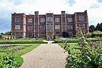 More images |
| Church of St James and St John | Dorrington | Parish Church | 13th century | 1 February 1967 | TF0762153375 53°04′00″N 0°23′43″W / 53.066786°N 0.39532°W / 53.066786; -0.39532 (Church of St James and St John) | 1254085 |  More images |
| Church of St Andrew | Ewerby, Ewerby and Evedon | Parish Church | 12th century | 1 February 1967 | TF1216647278 53°00′40″N 0°19′47″W / 53.011069°N 0.32964°W / 53.011069; -0.32964 (Church of St Andrew) | 1360562 |  More images |
| Church of St John the Baptist | Great Hale | Parish Church | 11th century | 1 February 1967 | TF1484142928 52°58′17″N 0°17′29″W / 52.971417°N 0.291332°W / 52.971417; -0.291332 (Church of St John the Baptist) | 1168767 |  More images |
| Church of St Andrew | Heckington | Parish Church | c. 1307 | 1 February 1967 | TF1429344122 52°58′56″N 0°17′57″W / 52.982262°N 0.299067°W / 52.982262; -0.299067 (Church of St Andrew) | 1360590 |  More images |
| Heckington Mill | Heckington | Tower Mill | 1830 | 23 November 1951 | TF1456443537 52°58′37″N 0°17′43″W / 52.976948°N 0.29524°W / 52.976948; -0.29524 (Heckington Mill) | 1168815 |  More images |
| Church of St Andrew | Helpringham | Parish Church | c. 1200 | 1 February 1967 | TF1387540750 52°57′07″N 0°18′23″W / 52.952053°N 0.306475°W / 52.952053; -0.306475 (Church of St Andrew) | 1168938 |  More images |
| Church of St Swithin | Leadenham | Parish Church | 13th century | 23 August 1967 | SK9503851747 53°03′16″N 0°35′01″W / 53.054539°N 0.583521°W / 53.054539; -0.583521 (Church of St Swithin) | 1147388 |  More images |
| Church of St Andrew | Leasingham | Parish Church | Late 12th century | 1 February 1967 | TF0565948553 53°01′26″N 0°25′34″W / 53.023848°N 0.426167°W / 53.023848; -0.426167 (Church of St Andrew) | 1261413 | 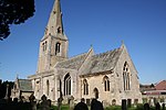 More images |
| Church of St Peter | Navenby | Parish Church | 13th century | 23 August 1967 | SK9865057843 53°06′31″N 0°31′40″W / 53.108665°N 0.527783°W / 53.108665; -0.527783 (Church of St Peter) | 1147458 |  More images |
| Former Parish Church of St Barbara | Haceby, Newton and Haceby | Church | 12th century | 1 February 1967 | TF0302936068 52°54′44″N 0°28′10″W / 52.91217°N 0.469331°W / 52.91217; -0.469331 (Former Parish Church of St Barbara) | 1147773 |  More images |
| Parish Church of St Botolph | Newton, Newton and Haceby | Church | 13th century | 1 February 1967 | TF0479236218 52°54′47″N 0°26′35″W / 52.913177°N 0.443076°W / 52.913177; -0.443076 (Parish Church of St Botolph) | 1061795 |  More images |
| Parish Church of St Peter | North Rauceby | Church | 12th century | 1 February 1967 | TF0211646448 53°00′20″N 0°28′47″W / 53.005619°N 0.479635°W / 53.005619; -0.479635 (Parish Church of St Peter) | 1360606 | 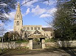 More images |
| Church of All Saints | North Scarle | Church | 12th century | 23 August 1967 | SK8482166737 53°11′27″N 0°43′55″W / 53.190968°N 0.731953°W / 53.190968; -0.731953 (Church of All Saints) | 1062005 |  More images |
| Church of Saint Peter | Norton Disney | Parish Church | 13th century | 23 August 1967 | SK8899158953 53°07′13″N 0°40′18″W / 53.120336°N 0.67172°W / 53.120336; -0.67172 (Church of Saint Peter) | 1360555 |  More images |
| Parish Church of St Peter and Paul | Osbournby | Church | 12th century | 1 February 1967 | TF0696038134 52°55′48″N 0°24′37″W / 52.929967°N 0.410219°W / 52.929967; -0.410219 (Parish Church of St Peter and Paul) | 1061760 |  More images |
| Church of St Clement | Rowston | Parish Church | 12th century | 1 February 1967 | TF0840356406 53°05′38″N 0°22′57″W / 53.093863°N 0.382634°W / 53.093863; -0.382634 (Church of St Clement) | 1064293 |  More images |
| Church of All Saints | Ruskington | Parish Church | 12th century | 1 February 1967 | TF0825851080 53°02′46″N 0°23′12″W / 53.046035°N 0.386588°W / 53.046035; -0.386588 (Church of All Saints) | 1261375 | 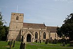 More images |
| Parish Church of St Denys | Silk Willoughby | Church | 12th century | 1 February 1967 | TF0572643003 52°58′26″N 0°25′37″W / 52.973963°N 0.426982°W / 52.973963; -0.426982 (Parish Church of St Denys) | 1061769 | 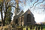 More images |
| Parish Church of St Denys | Sleaford | Parish Church | c. 1180 | 16 July 1949 | TF0688345893 52°59′59″N 0°24′32″W / 52.999703°N 0.408806°W / 52.999703; -0.408806 (Parish Church of St Denys) | 1062157 |  More images |
| Kyme Tower | South Kyme | Fortified House | Later than mid 14th century | 23 November 1990 | TF1685849622 53°01′52″N 0°15′32″W / 53.031127°N 0.258893°W / 53.031127; -0.258893 (Kyme Tower) | 1204786 | 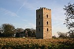 More images |
| Church of St Michael | Swaton | Parish Church | 12th century | 1 February 1967 | TF1330037521 52°55′23″N 0°18′58″W / 52.92316°N 0.316157°W / 52.92316; -0.316157 (Church of St Michael) | 1061820 |  More images |
| Church Tower to the North of Temple Farmhouse | Temple Bruer, Temple Bruer with Temple High Grange | Church | Early 13th century | 1 February 1967 | TF0085153709 53°04′16″N 0°29′46″W / 53.071106°N 0.496211°W / 53.071106; -0.496211 (Church Tower to the North of Temple Farmhouse) | 1254328 |  More images |
| Parish Church of St Peter | Threekingham | Church | 1688 | 1 February 1967 | TF0895436138 52°54′42″N 0°22′52″W / 52.911631°N 0.381236°W / 52.911631; -0.381236 (Parish Church of St Peter) | 1306911 | 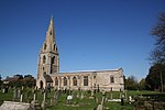 More images |
| Church of St Nicholas | Walcot, Walcot near Folkingham | Church | 12th century | 1 February 1967 | TF0600835163 52°54′12″N 0°25′31″W / 52.903459°N 0.425344°W / 52.903459; -0.425344 (Church of St Nicholas) | 1360637 |  More images |
| Cross in the Churchyard of the Church of St Nicholas | Walcot, Walcot near Folkingham | Cross/Sundial | 14th century | 11 January 1990 | TF0600635133 52°54′11″N 0°25′31″W / 52.90319°N 0.425384°W / 52.90319; -0.425384 (Cross in the Churchyard of the Church of St Nicholas) | 1061738 | Upload Photo |
| Church of St Chad | Welbourn | Parish Church | 12th century | 23 August 1967 | SK9686854510 53°04′45″N 0°33′19″W / 53.07904°N 0.555397°W / 53.07904; -0.555397 (Church of St Chad) | 1061852 |  More images |
| Church of All Saints | Wellingore | Parish Church | Late 12th century | 23 August 1967 | SK9822256538 53°05′49″N 0°32′04″W / 53.097017°N 0.534573°W / 53.097017; -0.534573 (Church of All Saints) | 1308424 |  More images |
| Church of St Mary | Wilsford | Church | 11th century | 1 February 1967 | TF0065843023 52°58′30″N 0°30′09″W / 52.975118°N 0.50242°W / 52.975118; -0.50242 (Church of St Mary) | 1360639 | 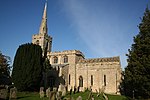 More images |
Notes
- ^ The date given is the date used by Historic England as significant for the initial building or that of an important part in the structure's description.
- ^ Sometimes known as OSGB36, the grid reference is based on the British national grid reference system used by the Ordnance Survey.
- ^ The "List Entry Number" is a unique number assigned to each listed building and scheduled monument by Historic England.
External links
- v
- t
- e
- Bedfordshire
- Berkshire
- Bristol
- Buckinghamshire
- Cambridgeshire
- Cheshire
- Cornwall
- Cumbria
- Derbyshire
- Devon
- Dorset
- Durham
- East Sussex
- East Riding of Yorkshire
- Essex
- Gloucestershire
- Greater London
- Greater Manchester
- Hampshire
- Herefordshire
- Hertfordshire
- Isle of Wight
- Kent
- Lancashire
- Leicestershire
- Lincolnshire
- Merseyside
- Norfolk
- North Yorkshire
- Northamptonshire
- Northumberland
- Nottinghamshire
- Oxfordshire
- Rutland
- Shropshire
- Somerset
- South Yorkshire
- Staffordshire
- Suffolk
- Surrey
- Tyne and Wear
- Warwickshire
- West Midlands
- West Sussex
- West Yorkshire
- Wiltshire
- Worcestershire
- Babergh
- Bath and North East Somerset
- Bradford
- Brighton and Hove
- Broadland
- Cheltenham
- Cheshire East
- Cheshire West and Chester
- Cotswold
- Craven
- Dartford
- Dover
- Forest Heath
- Forest of Dean
- Ipswich
- Maidstone
- Mendip
- Mid Suffolk
- North Somerset
- Sedgemoor
- South Gloucestershire
- South Somerset
- St Edmundsbury
- Stroud
- Suffolk Coastal
- Taunton Deane
- Tewkesbury
- Waveney
- West Somerset
- Churches
- War memorials
- 20th century


