Grade I listed buildings in South Somerset

South Somerset is a local government district in the English county of Somerset. The South Somerset district occupies an area of 370 square miles (958 km2),[1] stretching from its borders with Devon and Dorset to the edge of the Somerset Levels. The district has a population of about 158,000,[2] and has Yeovil as its administrative centre.
In the United Kingdom, the term listed building refers to a building or other structure officially designated as being of special architectural, historical or cultural significance; Grade I structures are those considered to be "buildings of exceptional interest".[3] Listing was begun by a provision in the Town and Country Planning Act 1947. Once listed, severe restrictions are imposed on the modifications allowed to a building's structure or its fittings. In England, the authority for listing under the Planning (Listed Buildings and Conservation Areas) Act 1990[4] rests with Historic England, a non-departmental public body sponsored by the Department for Digital, Culture, Media and Sport; local authorities have a responsibility to regulate and enforce the planning regulations.
There are 94 Grade I listed buildings in South Somerset. Most are Norman- or medieval-era churches, many of which are included in the Somerset towers—a collection of distinctive, mostly spireless Gothic church towers—but there are other religious buildings as well. Muchelney Abbey consists of the remains and foundations of a medieval Benedictine Abbey and an early Tudor house dating from the 16th century, formerly the lodgings of the resident abbot.[5] Stavordale Priory was built as a priory church in the 13th century and was converted into a private residence in 1533.[6] The Hamstone Stoke sub Hamdon Priory is a 14th-century former priest's house of the chantry chapel of St Nicholas,[7] which after 1518 become a farm known as Parsonage Farmhouse. It remained a farm until about 1960, and has been owned by the National Trust since 1946.[8]
Since the Reformation the 13th century Hanging Chapel in Langport has been a town hall,[9] courthouse,[10] grammar school,[11] museum,[10] and armoury[12] before becoming a masonic hall in 1891.[13] The house known as The Abbey in Charlton Mackrell takes its name from the site on which it was built, the Chantry Chapel of the Holy Spirit, founded in 1237.[14] Naish Priory, built around 1400 in East Coker, was never a priory,[15] and similarly the Abbey Farm House and Abbey Barn in Yeovil which date from around 1420,[16] have always been in lay-ownership; "abbey" was added to their names in the 19th century.[17] The 140-foot (43 m) Burton Pynsent Monument was designed in 1757,[18] by Lancelot "Capability" Brown for William Pitt, as a monument to Sir William Pynsent.[19] King Alfred's Tower, a 161 feet (49 m) high triangular edifice, stands near Egbert's stone, where it is believed Alfred the Great, King of Wessex, rallied the Saxons in May 878 before the Battle of Edington.[20] The tower's funder, Henry Hoare, planned for it to commemorate the end of the Seven Years' War against France and the accession of King George III.[21] The other Grade I listed buildings in South Somerset are manor houses, built over long periods by local Lords of the Manor. In 1907, the Tudor Barrington Court became the first country house acquired by the National Trust, on the recommendation of the antiquarian Canon Hardwicke Rawnsley.[22] Newton Surmaville was built between 1608 and 1612 for Robert Harbin, a Yeovil merchant, on the site of an earlier building, but was extensively altered and enhanced in the 1870s.[23] Lytes Cary and its associated chapel and gardens have parts dating to as early as the 14th century.[24] The architectural historian Nikolaus Pevsner praised it, saying "Yet all parts blend to perfection with one another and with the gentle sunny landscape that surrounds them."[25] The 17th century house[26] at Tintinhull is surrounded by a small 20th century Arts and Crafts garden.[27] Ven House, which stands on an artificially raised terrace, has a rectangular plan of seven bays by five bays, and is built of red brick in Flemish bond, with local Hamstone dressings; its north and south fronts are divided by two giant Corinthian pilasters.[28] The small William and Mary style[29] house was completed sometime between 1698 and 1700. It was enlarged between 1725 and 1730 by Decimus Burton, who provided a new drawing room for Sir W. Medleycott and also an orangery attached to the house.[30] Brympton d'Evercy, built in stages between about 1220 and the 18th century,[31] has been described, by Auberon Waugh, as "the most beautiful house in England".[32]
Map all coordinates using OpenStreetMap
Download coordinates as:
- KML
- GPX (all coordinates)
- GPX (primary coordinates)
- GPX (secondary coordinates)
Buildings
| Name | Location | Type | Completed [note 1] | Grid ref.[note 2] Geo-coordinates | Entry number [note 3] | Image | Ref. |
|---|---|---|---|---|---|---|---|
| Abbey Barn | Yeovil | Barn | c. 1420 | ST5366416240 50°56′37″N 2°39′39″W / 50.943726°N 2.660901°W / 50.943726; -2.660901 (Abbey Barn) | 1173463 | 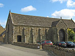 More images | [16]
|
| Abbey Farmhouse and farm gate and stile to north west corner | Montacute | Abbey Farmhouse | 16th century | ST4959016889 50°56′57″N 2°43′08″W / 50.949219°N 2.718975°W / 50.949219; -2.718975 (Abbey Farmhouse and farm gate and stile to north west corner) | 1057256 |  More images | [33] |
| Abbey Farm House | Yeovil | Farmhouse | c. 1420 | ST5365916254 50°56′38″N 2°39′40″W / 50.943852°N 2.660974°W / 50.943852; -2.660974 (Abbey Farm House) | 1056512 |  More images | [17]
|
| Alfred's Tower | Brewham | 1766 | ST7454635125 51°06′53″N 2°21′54″W / 51.114845°N 2.365016°W / 51.114845; -2.365016 (Alfred's Tower) | 1175610 |  More images | [34] | |
| Barrington Court | Barrington | Manor House | c. 1514 | ST3981318284 50°57′39″N 2°51′30″W / 50.960822°N 2.858369°W / 50.960822; -2.858369 (Barrington Court) | 1345920 | 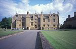 More images | [35] |
| Bow Bridge | Bruton | Footbridge | 15th century | ST6835734821 51°06′42″N 2°27′12″W / 51.111802°N 2.453403°W / 51.111802; -2.453403 (Bow Bridge) | 1176195 |  More images | [36] |
| Brympton d'Evercy Brympton House | Brympton | 13th century | ST5197515425 50°56′11″N 2°41′05″W / 50.936259°N 2.684832°W / 50.936259; -2.684832 (Brympton d'Evercy Brympton House) | 1057261 |  More images | [31] | |
| Burton Pynsent Monument | Burton Pynsent, Curry Rivel | Prospect tower or eyecatcher. | 1757 | ST3767625160 51°01′21″N 2°53′24″W / 51.022418°N 2.889976°W / 51.022418; -2.889976 (Burton Pynsent Monument) | 1039561 |  More images | [18]
|
| Church of All Saints | Alford | Parish Church | 15th century | ST6045232603 51°05′29″N 2°33′58″W / 51.091366°N 2.566079°W / 51.091366; -2.566079 (Church of All Saints) | 1056264 |  More images | [37] |
| Church of All Saints | Sutton Bingham, Closworth | Parish Church | 12th century | ST5478711123 50°53′52″N 2°38′39″W / 50.897805°N 2.644282°W / 50.897805; -2.644282 (Church of All Saints) | 1057236 |  More images | [38] |
| Church of All Saints | Langport | Parish Church | 12th century | ST4223126742 51°02′14″N 2°49′31″W / 51.037119°N 2.825292°W / 51.037119; -2.825292 (Church of All Saints) | 1056616 | 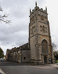 More images | [39] |
| Church of All Saints | Martock | Parish Church | 13th century | ST4612119154 50°58′09″N 2°46′07″W / 50.96927°N 2.768688°W / 50.96927; -2.768688 (Church of All Saints) | 1065888 |  More images | [40] |
| Church of All Saints | West Camel | Parish Church | Late 14th century | ST5802524628 51°01′10″N 2°35′59″W / 51.019484°N 2.599804°W / 51.019484; -2.599804 (Church of All Saints) | 1056769 |  More images | [41]
|
| Church of St Aldhelm and St Eadburgha | Broadway | Parish Church | 13th century | ST3296815901 50°56′19″N 2°57′19″W / 50.938639°N 2.955381°W / 50.938639; -2.955381 (Church of St Aldhelm and St Eadburgha) | 1248192 |  More images | [42] |
| Church of St Andrew | Brympton | Parish Church | 13th century | ST5192315380 50°56′09″N 2°41′08″W / 50.93585°N 2.685566°W / 50.93585; -2.685566 (Church of St Andrew) | 1057269 | 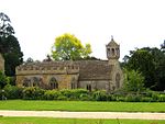 More images | [43] |
| Church of St Andrew | Curry Rivel | Parish Church | 13th century | ST3916925393 51°01′29″N 2°52′07″W / 51.024673°N 2.868731°W / 51.024673; -2.868731 (Church of St Andrew) | 1249281 |  More images | [44] |
| Church of St Andrew | High Ham | Parish Church | 12th century | ST4252831067 51°04′34″N 2°49′18″W / 51.076035°N 2.821745°W / 51.076035; -2.821745 (Church of St Andrew) | 1227591 |  More images | [45] |
| Church of St Andrew | Whitestaunton | Parish Church | 13th century | ST2804810496 50°53′22″N 3°01′28″W / 50.889449°N 3.024324°W / 50.889449; -3.024324 (Church of St Andrew) | 1263098 |  More images | [46]
|
| Church of St Barnabas | Queen Camel | Parish Church | 14th century | ST5973724953 51°01′21″N 2°34′32″W / 51.022529°N 2.575434°W / 51.022529; -2.575434 (Church of St Barnabas) | 1249203 |  More images | [47]
|
| Church of St Bartholomew | Crewkerne | Parish Church | 15th century | ST4395909800 50°53′06″N 2°47′53″W / 50.884957°N 2.798034°W / 50.884957; -2.798034 (Church of St Bartholomew) | 1208122 | 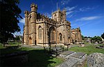 More images | [48] |
| Church of St Catherine | Drayton | Parish Church | 15th century | ST4051624768 51°01′09″N 2°50′58″W / 51.019195°N 2.849424°W / 51.019195; -2.849424 (Church of St Catherine) | 1236512 |  More images | [49] |
| Church of St Catherine | Fivehead | Parish Church | 12th century | ST3692923591 51°00′30″N 2°54′01″W / 51.008229°N 2.900351°W / 51.008229; -2.900351 (Church of St Catherine) | 1249584 |  More images | [50] |
| Church of St George | Hinton St George | Parish Church | 13th century | ST4184012685 50°54′38″N 2°49′43″W / 50.910688°N 2.828615°W / 50.910688; -2.828615 (Church of St George) | 1056124 | 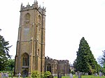 More images | [51]
|
| Church of St James | Beercrocombe | Parish Church | 13th century | ST3256420416 50°58′45″N 2°57′43″W / 50.979187°N 2.961968°W / 50.979187; -2.961968 (Church of St James) | 1248982 |  More images | [52] |
| Church of St James | Curry Mallet | Parish Church | 13th century | ST3339020908 50°59′01″N 2°57′01″W / 50.983706°N 2.950294°W / 50.983706; -2.950294 (Church of St James) | 1039557 |  More images | [53] |
| Church of St John the Baptist | Yeovil | Parish Church | Late 14th century | ST5567616053 50°56′32″N 2°37′56″W / 50.942203°N 2.632242°W / 50.942203; -2.632242 (Church of St John the Baptist) | 1055713 |  More images | [54]
|
| Church of St John the Evangelist | Milborne Port | Parish Church | 11th century | ST6763618538 50°57′55″N 2°27′44″W / 50.965346°N 2.462243°W / 50.965346; -2.462243 (Church of St John the Evangelist) | 1295666 |  More images | [55] |
| Church of St Margaret | Tintinhull | Parish Church | 13th century | ST4985119706 50°58′28″N 2°42′56″W / 50.974571°N 2.715649°W / 50.974571; -2.715649 (Church of St Margaret) | 1235407 |  More images | [56]
|
| Church of St Martin | Fivehead | Parish Church | 13th century | 1249564 |  More images | [57] | |
| Church of St Martin | Kingsbury Episcopi | Parish Church | 14th century | ST4364821080 50°59′11″N 2°48′15″W / 50.986351°N 2.804203°W / 50.986351; -2.804203 (Church of St Martin) | 1056885 | 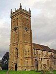 More images | [58]
|
| Church of St Martin | North Perrott | Parish Church | 12th century | ST4720709529 50°52′58″N 2°45′07″W / 50.882827°N 2.751827°W / 50.882827; -2.751827 (Church of St Martin) | 1056879 | 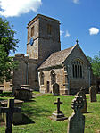 More images | [59]
|
| Church of St Mary | Bruton | Parish Church | c. 1350 | ST6845534795 51°06′42″N 2°27′07″W / 51.111573°N 2.452001°W / 51.111573; -2.452001 (Church of St Mary) | 1056408 |  More images | [60] |
| Church of St Mary | Ilminster | Parish Church | 15th century | ST3602014572 50°55′37″N 2°54′42″W / 50.927037°N 2.911717°W / 50.927037; -2.911717 (Church of St Mary) | 1208692 |  More images | [61] |
| Church of St Mary | Limington | Parish Church | Late 14th century | ST5415822372 50°59′56″N 2°39′17″W / 50.998903°N 2.654645°W / 50.998903; -2.654645 (Church of St Mary) | 1056844 |  More images | [62] |
| Church of St Mary | Marston Magna | Parish Church | c. 1360 | 1296098 |  More images | [63] | |
| Church of St Mary | Mudford | Parish Church | 14th century | ST5736619944 50°58′38″N 2°36′31″W / 50.977318°N 2.608647°W / 50.977318; -2.608647 (Church of St Mary) | 1056790 |  More images | [64] |
| Church of St Mary | Rimpton | Parish Church | Early 13th century | ST6104321858 50°59′41″N 2°33′23″W / 50.99479°N 2.556481°W / 50.99479; -2.556481 (Church of St Mary) | 1295576 |  More images | [65] |
| Church of St Mary Magdalene | Stocklinch | Parish Church | 13th century | ST3830217187 50°57′03″N 2°52′47″W / 50.950799°N 2.879695°W / 50.950799; -2.879695 (Church of St Mary Magdalene) | 1057061 |  More images | [66]
|
| Church of St Mary the Virgin | Barrington | Parish Church | 13th century | ST3890818118 50°57′33″N 2°52′16″W / 50.959234°N 2.871226°W / 50.959234; -2.871226 (Church of St Mary the Virgin) | 1056904 |  More images | [67] |
| Church of St Mary the Virgin | Chard | Parish Church | Late 11th century | ST3230308207 50°52′10″N 2°57′48″W / 50.869384°N 2.963415°W / 50.869384; -2.963415 (Church of St Mary the Virgin) | 1297140 |  More images | [68] |
| Church of St Mary the Virgin | Isle Abbotts | Parish Church | 13th century | ST3526520947 50°59′03″N 2°55′25″W / 50.984271°N 2.923594°W / 50.984271; -2.923594 (Church of St Mary the Virgin) | 1249594 |  More images | [69] |
| Church of St Mary the Virgin | Norton Sub Hamdon | Parish Church | 13th century | ST4706015956 50°56′26″N 2°45′17″W / 50.940603°N 2.754851°W / 50.940603; -2.754851 (Church of St Mary the Virgin) | 1253811 |  More images | [70] |
| Church of St Mary the Virgin | East Stoke, Stoke-sub-Hamdon | Parish Church | 12th century | ST4839217277 50°57′09″N 2°44′10″W / 50.952602°N 2.736082°W / 50.952602; -2.736082 (Church of St Mary the Virgin) | 1260420 | 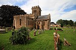 More images | [71]
|
| Church of St Michael | North Cadbury | Parish Church | 1417 | ST6354227054 51°02′30″N 2°31′17″W / 51.041676°N 2.521398°W / 51.041676; -2.521398 (Church of St Michael) | 1178133 |  More images | [72] |
| Church of St Michael | Shepton Beauchamp | Parish Church | 13th century | ST4029817159 50°57′03″N 2°51′05″W / 50.950757°N 2.851279°W / 50.950757; -2.851279 (Church of St Michael) | 1237246 |  More images | [73]
|
| Church of St Michael and All Angels | Somerton | Parish Church | 13th century | ST4904428617 51°03′17″N 2°43′42″W / 51.054623°N 2.728396°W / 51.054623; -2.728396 (Church of St Michael and All Angels) | 1056695 |  More images | [74]
|
| Church of St Nicholas | Combe St Nicholas | Parish Church | 13th century | ST3015111249 50°53′47″N 2°59′40″W / 50.896478°N 2.994574°W / 50.896478; -2.994574 (Church of St Nicholas) | 1248506 |  More images | [75] |
| Church of St Peter | Yeovilton | Church | Early 14th century | ST5456024929 51°01′19″N 2°38′57″W / 51.021927°N 2.649238°W / 51.021927; -2.649238 (Church of St Peter) | 1295400 | 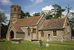 More images | [76] |
| Church of St Peter and St Paul | Charlton Adam, Charlton Mackrell | Parish Church | 14th century | ST5351028664 51°03′20″N 2°39′53″W / 51.055426°N 2.664688°W / 51.055426; -2.664688 (Church of St Peter and St Paul) | 1056762 |  More images | [77] |
| Church of St Peter and St Paul | Muchelney | Parish Church | 15th century | ST4289724908 51°01′15″N 2°48′56″W / 51.020695°N 2.815505°W / 51.020695; -2.815505 (Church of St Peter and St Paul) | 1247849 |  More images | [78]
|
| Church of St Peter and St Paul | South Petherton | Parish Church | 13th century | ST4323616862 50°56′54″N 2°48′34″W / 50.948384°N 2.809412°W / 50.948384; -2.809412 (Church of St Peter and St Paul) | 1056959 |  More images | [79]
|
| Church of St Vincent | Ashington, Chilton Cantelo | Parish Church | 13th century | ST5611121410 50°59′25″N 2°37′36″W / 50.990406°N 2.626699°W / 50.990406; -2.626699 (Church of St Vincent) | 1345984 |  More images | [80] |
| Church of the Blessed Virgin Mary | Huish Episcopi | Parish Church | 12th century | ST4271626625 51°02′10″N 2°49′06″W / 51.036115°N 2.818357°W / 51.036115; -2.818357 (Church of the Blessed Virgin Mary) | 1056633 |  More images | [81]
|
| Church of the Holy Trinity | Wyke Champflower, Bruton | Parish Church | 1623 | ST6619034310 51°06′25″N 2°29′04″W / 51.107083°N 2.48431°W / 51.107083; -2.48431 (Church of the Holy Trinity) | 1366339 |  More images | [82] |
| Church of the Holy Trinity | Long Sutton | Parish Church | 15th century | ST4695625305 51°01′29″N 2°45′28″W / 51.024654°N 2.757698°W / 51.024654; -2.757698 (Church of the Holy Trinity) | 1236060 |  More images | [83] |
| Church of the Holy Trinity | Sutton Montis, South Cadbury | Parish Church | 12th century | ST6243324799 51°01′17″N 2°32′13″W / 51.021328°N 2.536981°W / 51.021328; -2.536981 (Church of the Holy Trinity) | 1259115 |  More images | [84]
|
| Church without dedication | High Ham | Parish Church | Early 17th century | ST4324029100 51°03′30″N 2°48′41″W / 51.058421°N 2.811273°W / 51.058421; -2.811273 (Church without dedication) | 1346080 |  More images | [85]
|
| Coker Court | East Coker | Manor House | 15th century | ST5384412164 50°54′26″N 2°39′28″W / 50.90709°N 2.657822°W / 50.90709; -2.657822 (Coker Court) | 1057176 |  More images | [86] |
| Corridor linking Ven House and the Orangery | Milborne Port | Pavilion to Country house | 1836 | ST6802318440 50°57′52″N 2°27′24″W / 50.964487°N 2.456723°W / 50.964487; -2.456723 (Corridor linking Ven House and the Orangery) | 1056288 |  Upload Photo | [87] |
| Hymerford House | East Coker | House | 15th century | ST5390412924 50°54′50″N 2°39′25″W / 50.913929°N 2.657065°W / 50.913929; -2.657065 (Hymerford House) | 1057157 |  More images | [88]
|
| Lytes Cary | Charlton Mackrell | Manor House | 14th century | ST5331726557 51°02′11″N 2°40′02″W / 51.036465°N 2.667169°W / 51.036465; -2.667169 (Lytes Cary) | 1056764 | 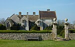 More images | [24] |
| Main entrance gateway, 35 metres North-West of Ven House | Milborne Port | Entrance Gateway | 1730 | ST6810618500 50°57′54″N 2°27′20″W / 50.965031°N 2.455547°W / 50.965031; -2.455547 (Main entrance gateway, 35 metres North-West of Ven House) | 1175037 | Upload Photo | [89] |
| Manor House | West Coker | Manor House | c. 1500 | ST5199113520 50°55′09″N 2°41′04″W / 50.919132°N 2.684353°W / 50.919132; -2.684353 (Manor House) | 1345845 |  More images | [90]
|
| Midelney Manor, forecourt and garden walling with gate piers | Drayton | Manor House | Late 16th century | ST4101622879 51°00′08″N 2°50′31″W / 51.002262°N 2.841989°W / 51.002262; -2.841989 (Midelney Manor, forecourt and garden walling with gate piers) | 1056918 | 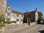 More images | [91]
|
| Montacute House | Montacute | Country House | c. 1601 | ST4993617153 50°57′06″N 2°42′51″W / 50.951623°N 2.714086°W / 50.951623; -2.714086 (Montacute House) | 1252021 |  More images | [92]
|
| Naish Priory, including attached priory cottage and north boundary railings | East Coker | c. 1400 | ST5382513865 50°55′21″N 2°39′30″W / 50.922384°N 2.658308°W / 50.922384; -2.658308 (Naish Priory, including attached priory cottage and north boundary railings) | 1057189 |  More images | [15] | |
| Newton Surmaville | Barwick | Country House | 1612 | ST5652915395 50°56′11″N 2°37′12″W / 50.936352°N 2.620024°W / 50.936352; -2.620024 (Newton Surmaville) | 1345788 |  More images | [23] |
| North Cadbury Court | North Cadbury | 1610 | ST6359827026 51°02′29″N 2°31′14″W / 51.041428°N 2.520596°W / 51.041428; -2.520596 (North Cadbury Court) | 1178213 |  More images | [93]
| |
| North-east and south-east pavilions to east forecourt, Montacute House | Montacute | c. 1601 | ST4999317117 50°57′05″N 2°42′48″W / 50.951304°N 2.71327°W / 50.951304; -2.71327 (North-east and south-east pavilions to east forecourt, Montacute House) | 1262475 |  | [94] | |
| North-East Pavilion and balustraded brick wall, Ven House | Milborne Port | Pavilion to country house | 1730 | ST6808518426 50°57′52″N 2°27′21″W / 50.964364°N 2.455839°W / 50.964364; -2.455839 (North-East Pavilion and balustraded brick wall, Ven House) | 1366378 | Upload Photo | [95] |
| North-West Pavilion and balustraded link wall, Ven House | Milborne Port | Pavilion to Country house | 1730 | ST6803118472 50°57′53″N 2°27′24″W / 50.964775°N 2.456612°W / 50.964775; -2.456612 (North-West Pavilion and balustraded link wall, Ven House) | 1056287 | Upload Photo | [96] |
| Parsonage Farmhouse The Priory | Stoke-sub-Hamdon | 14th century | ST4735317408 50°57′13″N 2°45′03″W / 50.953685°N 2.750891°W / 50.953685; -2.750891 (Parsonage Farmhouse The Priory) | 1260178 |  More images | [97]
| |
| Sexey's Hospital west wing, with chapel | Bruton | Almshouse | c. 1638 | ST6810834713 51°06′39″N 2°27′25″W / 51.110817°N 2.456951°W / 51.110817; -2.456951 (Sexey's Hospital west wing, with chapel) | 1176086 |  More images | [98] |
| Stavordale Priory | Charlton Musgrove | 13th century | ST7363732020 51°05′13″N 2°22′40″W / 51.086884°N 2.377774°W / 51.086884; -2.377774 (Stavordale Priory) | 1176699 |  More images | [6] | |
| Shanks House | Cucklington | Country House | 17th century | ST7533226667 51°02′20″N 2°21′12″W / 51.038825°N 2.353208°W / 51.038825; -2.353208 (Shanks House) | 1222369 |  More images | [99] |
| Swell Court Farmhouse | Fivehead | Manor House | 15th century | ST3689623579 51°00′29″N 2°54′03″W / 51.008117°N 2.90082°W / 51.008117; -2.90082 (Swell Court Farmhouse) | 1249582 |  More images | [100] |
| Stabling and other outbuildings, attached to East side of Ven House | Milborne Port | Stables | 1730 | ST6807818403 50°57′51″N 2°27′21″W / 50.964157°N 2.455937°W / 50.964157; -2.455937 (Stabling and other outbuildings, attached to East side of Ven House) | 1366379 | Upload Photo | [101] |
| Terrace along South Garden front, Ven House | Milborne Port | Pavilion to Country house | 1730 | ST6805618403 50°57′51″N 2°27′23″W / 50.964156°N 2.45625°W / 50.964156; -2.45625 (Terrace along South Garden front, Ven House) | 1056289 | Upload Photo | [102]
|
| The Abbey | Charlton Adam, Charlton Mackrell | House | Late 16th century | ST5355428690 51°03′20″N 2°39′51″W / 51.055663°N 2.664064°W / 51.055663; -2.664064 (The Abbey) | 1056727 | 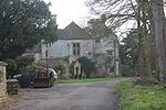 More images | [14] |
| The Abbot's House, Muchelney Abbey | Muchelney | 14th century | ST4284924847 51°01′13″N 2°48′58″W / 51.020142°N 2.816179°W / 51.020142; -2.816179 (The Abbot's House, Muchelney Abbey) | 1236790 |  More images | [103]
| |
| The Chantry House The Dower House | Brympton | 13th century | ST5194115398 50°56′10″N 2°41′07″W / 50.936014°N 2.685313°W / 50.936014; -2.685313 (The Chantry House The Dower House) | 1263253 |  | [104] | |
| The Dogs | Wincanton | House | c. 1650 | ST7133728484 51°03′18″N 2°24′37″W / 51.054978°N 2.41033°W / 51.054978; -2.41033 (The Dogs) | 1273913 | Upload Photo | [105]
|
| The Hanging Chapel | Langport | Gateway | 13th century | ST4233026747 51°02′14″N 2°49′26″W / 51.037173°N 2.823881°W / 51.037173; -2.823881 (The Hanging Chapel) | 1056615 | 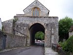 More images | [13] |
| The Orangery, attached to the South West corner of Ven House | Milborne Port | Entrance Gateway | 1730 | ST6801318444 50°57′52″N 2°27′25″W / 50.964522°N 2.456866°W / 50.964522; -2.456866 (The Orangery, attached to the South West corner of Ven House) | 1295483 | Upload Photo | [106] |
| The Treasurers House | Martock | 13th century | 50°58′07″N 2°46′02″W / 50.9686°N 2.7673°W / 50.9686; -2.7673 (The Treasurers House) | 1225764 |  More images | [107] | |
| Tintinhull Court | Tintinhull | House | 1678 | ST4987319669 50°58′27″N 2°42′55″W / 50.974241°N 2.71533°W / 50.974241; -2.71533 (Tintinhull Court) | 1235516 |  More images | [108]
|
| Tintinhull House | Tintinhull | House | 17th century | ST5024619742 50°58′30″N 2°42′36″W / 50.974929°N 2.710028°W / 50.974929; -2.710028 (Tintinhull House) | 1265231 |  More images | [26]
|
| Ven House | Milborne Port | County House | 1730 | ST6804518430 50°57′52″N 2°27′23″W / 50.964398°N 2.456409°W / 50.964398; -2.456409 (Ven House) | 1056286 |  More images | [109] |
| Walls, turrets and gateway to east forecourt of Montacute House | Montacute | c. 1601 | ST4997917151 50°57′06″N 2°42′49″W / 50.951609°N 2.713474°W / 50.951609; -2.713474 (Walls, turrets and gateway to east forecourt of Montacute House) | 1252025 | Upload Photo | [110]
| |
| Waterloo House and Manor Court House | Fore Street, Chard | House and courtroom | Late 16th century | ST3218008600 50°52′22″N 2°57′55″W / 50.872903°N 2.965235°W / 50.872903; -2.965235 (Waterloo House and Manor Court House) | 1197449 |  More images | [111] |
| Wayford Manor House | Wayford | Manor House | c. 1600 | ST4046006627 50°51′22″N 2°50′50″W / 50.856077°N 2.847252°W / 50.856077; -2.847252 (Wayford Manor House) | 1177681 |  More images | [112] |
| Whitestaunton Manor | Whitestaunton | Manor House | 15th century | ST2800410471 50°53′21″N 3°01′30″W / 50.889219°N 3.024944°W / 50.889219; -3.024944 (Whitestaunton Manor) | 1250783 |  More images | [113]
|
| Wigborough Manor House | South Petherton | Manor House | 1585 | ST4479515147 50°55′59″N 2°47′13″W / 50.933116°N 2.786962°W / 50.933116; -2.786962 (Wigborough Manor House) | 1056928 |  More images | [114] |
| Earnshill House | Hambridge and Westport | Country house | ST3859621722 | 1249217 |  More images | [115] |
See also
- Grade I listed buildings in Somerset
- List of Somerset towers
- Grade II* listed buildings in South Somerset
Notes
- ^ The date given is the date used by Historic England as significant for the initial building or that of an important part in the structure's description.
- ^ Sometimes known as OSGB36, the grid reference is based on the British national grid reference system used by the Ordnance Survey.
- ^ The "List Entry Number" is a unique number assigned to each listed building and scheduled monument by Historic England.
References
- ^ "An introduction to South Somerset" (PDF). South Somerset District Council. Archived from the original (PDF) on 30 August 2012. Retrieved 29 March 2017.
- ^ "Population of South Somerset". South Somerset District Council. Archived from the original on 30 October 2007. Retrieved 11 July 2009.
- ^ "Listed Buildings". Historic England. Archived from the original on 19 March 2017. Retrieved 23 August 2017.
- ^ "Planning (Listed Buildings and Conservation Areas) Act 1990 (c. 9)". Ministry of Justice. Archived from the original on 18 April 2010. Retrieved 17 December 2007.
- ^ Historic England. "The Abbot's House, Muchelney Abbey (1236790)". National Heritage List for England. Retrieved 25 September 2007.
- ^ a b Historic England. "Stavordale Priory (1176699)". National Heritage List for England. Retrieved 3 April 2015.
- ^ "The Priory, or Parsonage Farmhouse (formerly listed as The Priory or Parsonage Farmhouse (Ruined portion)), North Street (West side), Stoke sub Hamdon". Somerset Historic Environment Record. Somerset County Council. Archived from the original on 3 October 2016. Retrieved 7 July 2009.
- ^ "Stoke sub Hamdon Priory". National Trust. Archived from the original on 24 October 2007. Retrieved 11 November 2007.
- ^ "The Hanging Chapel and a medieval gateway at The Hill". Somerset Historic Environment Record. Somerset County Council. Archived from the original on 3 October 2016. Retrieved 7 July 2009.
- ^ a b "Langport". Victoria County History: A History of the County of Somerset: Volume 3. British History Online. 1974. pp. 16–38. Archived from the original on 21 October 2012. Retrieved 7 July 2009.
- ^ "Gate, Bridge and Causeway Chapels: Chapter 3". English Heritage. Archived from the original on 6 June 2011. Retrieved 7 July 2009.
- ^ "Langport and River Parret education pack" (PDF). Langport and River Parret visitor centre. p. 9. Retrieved 8 November 2010.[permanent dead link]
- ^ a b Historic England. "The Hanging Chapel (1056615)". National Heritage List for England. Retrieved 3 April 2015.
- ^ a b Historic England. "The Abbey (1056727)". National Heritage List for England. Retrieved 3 April 2015.
- ^ a b Historic England. "Naish Priory, including attached priory cottage and north boundary railings (1057189)". National Heritage List for England. Retrieved 3 April 2015.
- ^ a b Historic England. "Abbey Barn (1173463)". National Heritage List for England. Retrieved 3 April 2015.
- ^ a b Historic England. "Abbey Farm House (1056512)". National Heritage List for England. Retrieved 3 April 2015.
- ^ a b Historic England. "Burton Pynsent Monument (1039561)". National Heritage List for England. Retrieved 3 April 2015.
- ^ "Curry Rivel Column (Burton Pynsent)". Folly Towers. Archived from the original on 22 February 2008. Retrieved 5 July 2008.
- ^ "King Alfred's Tower". King Alfred's Tower. Archived from the original on 28 July 2017. Retrieved 25 November 2012.
- ^ Holt, Jonathan (2007). Somerset Follies. Bath: Akeman Press. pp. 46–47. ISBN 978-0-9546138-7-7.
- ^ "Barrington Court Park, Barrington". Somerset Historic Environment Record. Somerset County Council. Archived from the original on 3 October 2016. Retrieved 11 July 2009.
- ^ a b Historic England. "Newton Surmaville (1345788)". National Heritage List for England. Retrieved 3 April 2015.
- ^ a b Historic England. "Lytes Cary (1056764)". National Heritage List for England. Retrieved 3 April 2015.
- ^ Pevsner, Nikolaus (1958). The Buildings of England, South and West Somerset. Penguin Books; Reprinted by Yale University Press, 2003. pp. 228–229.
- ^ a b Historic England. "Tintinhull House (1265231)". National Heritage List for England. Retrieved 3 April 2015.
- ^ "Tintinhull Garden". National Trust. Archived from the original on 14 June 2009. Retrieved 8 June 2009.
- ^ "Milborne Port". A History of the County of Somerset: Volume 7: Bruton, Horethorne and Norton Ferris Hundreds. British History Online. 1999. pp. 138–156. Archived from the original on 25 May 2011. Retrieved 8 July 2009.
- ^ Churchill, Penny (16 June 2006). "For sale: Ven House, Dorset". Country Life. Archived from the original on 28 September 2011. Retrieved 8 July 2009.
- ^ Historic England. "The Orangery, attached to the South West corner of Ven House (1295483)". National Heritage List for England. Retrieved 8 July 2009.
- ^ a b Historic England. "Brympton d'Evercy Brympton House (1057261)". National Heritage List for England. Retrieved 6 July 2015.
- ^ Waugh, Auberon (31 August 1992). "But life goes on". Way of the World. Daily Telegraph. p. 17.
- ^ Historic England. "Abbey Farmhouse and farm gate and stile to north west corner (1057256)". National Heritage List for England. Retrieved 3 April 2015.
- ^ Historic England. "Alfred's Tower (1175610)". National Heritage List for England. Retrieved 6 July 2015.
- ^ Historic England. "Barrington Court (1345920)". National Heritage List for England. Retrieved 3 April 2015.
- ^ Historic England. "Bow Bridge (1176195)". National Heritage List for England. Retrieved 3 April 2015.
- ^ Historic England. "Church of All Saints (1056264)". National Heritage List for England. Retrieved 3 April 2015.
- ^ Historic England. "Church of All Saints (1057236)". National Heritage List for England. Retrieved 3 April 2015.
- ^ Historic England. "Church of All Saints (1056616)". National Heritage List for England. Retrieved 3 April 2015.
- ^ Historic England. "Church of All Saints (1065888)". National Heritage List for England. Retrieved 3 April 2015.
- ^ Historic England. "Church of All Saints (1056769)". National Heritage List for England. Retrieved 3 April 2015.
- ^ Historic England. "Church of St Aldhelm and St Eadburgha (1248192)". National Heritage List for England. Retrieved 3 April 2015.
- ^ Historic England. "Church of St Andrew (1057269)". National Heritage List for England. Retrieved 3 April 2015.
- ^ Historic England. "Church of St Andrew (1249281)". National Heritage List for England. Retrieved 3 April 2015.
- ^ Historic England. "Church of St Andrew (1227591)". National Heritage List for England. Retrieved 3 April 2015.
- ^ Historic England. "Church of St Andrew (1263098)". National Heritage List for England. Retrieved 3 April 2015.
- ^ Historic England. "Church of St Barnabas (1249203)". National Heritage List for England. Retrieved 3 April 2015.
- ^ Historic England. "Church of St Bartholomew (1208122)". National Heritage List for England. Retrieved 3 April 2015.
- ^ Historic England. "Church of St Catherine (1236512)". National Heritage List for England. Retrieved 3 April 2015.
- ^ Historic England. "Church of St Catherine (1249584)". National Heritage List for England. Retrieved 3 April 2015.
- ^ Historic England. "Church of St George (1056124)". National Heritage List for England. Retrieved 3 April 2015.
- ^ Historic England. "Church of St James (1248982)". National Heritage List for England. Retrieved 3 April 2015.
- ^ Historic England. "Church of St James (1039557)". National Heritage List for England. Retrieved 3 April 2015.
- ^ Historic England. "Church of St John the Baptist (1055713)". National Heritage List for England. Retrieved 3 April 2015.
- ^ Historic England. "Church of St John the Evangelist (1295666)". National Heritage List for England. Retrieved 3 April 2015.
- ^ Historic England. "Church of St Margaret (1235407)". National Heritage List for England. Retrieved 3 April 2015.
- ^ Historic England. "Church of St Martin (1249564)". National Heritage List for England. Retrieved 3 April 2015.
- ^ Historic England. "Church of St Martin (1056885)". National Heritage List for England. Retrieved 3 April 2015.
- ^ Historic England. "Church of St Martin (1056879)". National Heritage List for England. Retrieved 3 April 2015.
- ^ Historic England. "Church of St Mary (1056408)". National Heritage List for England. Retrieved 3 April 2015.
- ^ Historic England. "Church of St Mary (1208692)". National Heritage List for England. Retrieved 3 April 2015.
- ^ Historic England. "Church of St Mary (1056844)". National Heritage List for England. Retrieved 3 April 2015.
- ^ Historic England. "Church of St Mary (1296098)". National Heritage List for England. Retrieved 3 April 2015.
- ^ Historic England. "Church of St Mary (1056790)". National Heritage List for England. Retrieved 3 April 2015.
- ^ Historic England. "Church of St Mary (1295576)". National Heritage List for England. Retrieved 3 April 2015.
- ^ Historic England. "Church of St Mary Magdalene (1057061)". National Heritage List for England. Retrieved 3 April 2015.
- ^ Historic England. "Church of St Mary the Virgin (1056904)". National Heritage List for England. Retrieved 3 April 2015.
- ^ Historic England. "Church of St Mary the Virgin (1297140)". National Heritage List for England. Retrieved 3 April 2015.
- ^ Historic England. "Church of St Mary the Virgin (1249594)". National Heritage List for England. Retrieved 3 April 2015.
- ^ Historic England. "Church of St Mary the Virgin (1253811)". National Heritage List for England. Retrieved 3 April 2015.
- ^ Historic England. "Church of St Mary the Virgin (1260420)". National Heritage List for England. Retrieved 3 April 2015.
- ^ Historic England. "Church of St Michael (1178133)". National Heritage List for England. Retrieved 3 April 2015.
- ^ Historic England. "Church of St Michael (1237246)". National Heritage List for England. Retrieved 3 April 2015.
- ^ Historic England. "Church of St Michael and All Angels (1056695)". National Heritage List for England. Retrieved 3 April 2015.
- ^ Historic England. "Church of St Nicholas (1248506)". National Heritage List for England. Retrieved 3 April 2015.
- ^ Historic England. "Church of St Peter (1295400)". National Heritage List for England. Retrieved 3 April 2015.
- ^ Historic England. "Church of St Peter and St Paul (1056762)". National Heritage List for England. Retrieved 3 April 2015.
- ^ Historic England. "Church of St Peter and St Paul (1247849)". National Heritage List for England. Retrieved 3 April 2015.
- ^ Historic England. "Church of St Peter and St Paul (1056959)". National Heritage List for England. Retrieved 3 April 2015.
- ^ Historic England. "Church of St Vincent (1345984)". National Heritage List for England. Retrieved 3 April 2015.
- ^ Historic England. "Church of the Blessed Virgin Mary (1056633)". National Heritage List for England. Retrieved 3 April 2015.
- ^ Historic England. "Church of the Holy Trinity (1366339)". National Heritage List for England. Retrieved 3 April 2015.
- ^ Historic England. "Church of the Holy Trinity (1236060)". National Heritage List for England. Retrieved 3 April 2015.
- ^ Historic England. "Church of the Holy Trinity (1259115)". National Heritage List for England. Retrieved 3 April 2015.
- ^ Historic England. "Church without dedication (1346080)". National Heritage List for England. Retrieved 3 April 2015.
- ^ Historic England. "Coker Court (1057176)". National Heritage List for England. Retrieved 3 April 2015.
- ^ Historic England. "Corridor linking Ven House and the Orangery (1056288)". National Heritage List for England. Retrieved 3 April 2015.
- ^ Historic England. "Hymerford House (1057157)". National Heritage List for England. Retrieved 3 April 2015.
- ^ Historic England. "Main entrance gateway, 35 metres North-West of Ven House (1175037)". National Heritage List for England. Retrieved 3 April 2015.
- ^ Historic England. "Manor House (1345845)". National Heritage List for England. Retrieved 3 April 2015.
- ^ Historic England. "Midelney Manor (1056918)". National Heritage List for England. Retrieved 3 April 2015.
- ^ Historic England. "Montacute House (1252021)". National Heritage List for England. Retrieved 3 April 2015.
- ^ Historic England. "North Cadbury Court (1178213)". National Heritage List for England. Retrieved 3 April 2015.
- ^ Historic England. "North-east and south-east pavilions to east forecourt, Montacute House (1262475)". National Heritage List for England. Retrieved 3 April 2015.
- ^ Historic England. "North-East Pavilion and balustraded brick wall, Ven House (1366378)". National Heritage List for England. Retrieved 3 April 2015.
- ^ Historic England. "North-West Pavilion and balustraded link wall, Ven House (1056287)". National Heritage List for England. Retrieved 3 April 2015.
- ^ Historic England. "Parsonage Farmhouse The Priory (1260178)". National Heritage List for England. Retrieved 3 April 2015.
- ^ Historic England. "Sexey's Hospital west wing, with chapel (1176086)". National Heritage List for England. Retrieved 6 July 2015.
- ^ Historic England. "Shanks House (1222369)". National Heritage List for England. Retrieved 3 April 2015.
- ^ Historic England. "Swell Court Farmhouse (1222369)". National Heritage List for England. Retrieved 3 April 2015.
- ^ Historic England. "Stabling and other outbuildings, attached to East side of Ven House (1366379)". National Heritage List for England. Retrieved 3 April 2015.
- ^ Historic England. "Terrace along South Garden front, Ven House (1056289)". National Heritage List for England. Retrieved 3 April 2015.
- ^ Historic England. "The Abbot's House, Muchelney Abbey (1236790)". National Heritage List for England. Retrieved 6 July 2015.
- ^ Historic England. "The Chantry House The Dower House (1263253)". National Heritage List for England. Retrieved 3 April 2015.
- ^ Historic England. "The Dogs (1273913)". National Heritage List for England. Retrieved 3 April 2015.
- ^ Historic England. "The Orangery, attached to the South West corner of Ven House (1295483)". National Heritage List for England. Retrieved 3 April 2015.
- ^ Historic England. "The Treasurers House (1225764)". National Heritage List for England. Retrieved 3 April 2015.
- ^ Historic England. "Tintinhull Court (1235516)". National Heritage List for England. Retrieved 3 April 2015.
- ^ Historic England. "Ven House (1056286)". National Heritage List for England. Retrieved 3 April 2015.
- ^ Historic England. "Walls, turrets and gateway to east forecourt of Montacute House (1252025)". National Heritage List for England. Retrieved 3 April 2015.
- ^ Historic England. "Waterloo House and Manor Court House (1197449)". National Heritage List for England. Retrieved 3 April 2015.
- ^ Historic England. "Wayford Manor House (1177681)". National Heritage List for England. Retrieved 3 April 2015.
- ^ Historic England. "Whitestaunton Manor (1250783)". National Heritage List for England. Retrieved 3 April 2015.
- ^ Historic England. "Wigborough Manor House (1056928)". National Heritage List for England. Retrieved 3 April 2015.
- ^ Historic England. "Earnshill House (1249217)". National Heritage List for England. Retrieved 11 March 2023.
External links
- South Somerset Council page on listed buildings
- v
- t
- e


