Ville Platte
| Ville Platte | |
| city | |
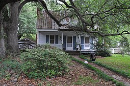 Jean Marie Laran House. | |
| Land |  USA USA |
|---|---|
| Delstat | Louisiana |
| Parish | Evangeline Parish |
| Höjdläge | 22 m ö.h. |
| Koordinater | 30°41′17″N 92°16′17″V / 30.68806°N 92.27139°V / 30.68806; -92.27139 |
| Yta | 10,4 km² (2010) |
| - land | 10,4 km² |
| - vatten | 0,0 km² |
| Folkmängd | 7 430 (2010) |
| Befolkningstäthet | 714 invånare/km² |
| Tidszon | CST (UTC-6) |
| - sommartid | CDT (UTC-5) |
| ZIP-kod | 70586 |
| Riktnummer | 337 |
| FIPS | 2278715 |
| Geonames | 4344651 |
  Ortens läge i Louisiana | |
 Louisianas läge i USA | |
| Webbplats: cityofvilleplatte.com | |
Ville Platte är administrativ huvudort i Evangeline Parish i Louisiana.[1][2][3] Vid 2010 års folkräkning hade Ville Platte 7 430 invånare.[4]
Källor
- ^ Louisiana Parish Map with Parish Seat Cities. Geology.com Geoscience News and Information. Läst 31 augusti 2017.
- ^ Ville Platte, LA. Map Quest. Läst 31 augusti 2017.
- ^ Profile for Ville Platte, Louisiana Arkiverad 17 juni 2017 hämtat från the Wayback Machine.. ePodunk. Läst 31 augusti 2017.
- ^ 2010 Census Population of Ville Platte, Louisiana Arkiverad 31 augusti 2017 hämtat från the Wayback Machine.. Census Viewer. Läst 31 augusti 2017.
Bilder & media
|


