Mokhotlong (distrikt)
| Mokhotlong | |||
|---|---|---|---|
 | |||
| | |||
| Land |  Lesotho Lesotho | ||
| Status | Distrikt (district) | ||
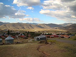
| Adm. senter | Mokhotlong | ||
| Areal | 4 075 km² | ||
| Befolkning | 97 713 (2006) | ||
| Bef.tetthet | 23,98 innb./km² | ||
 Mokhotlong 29°20′00″S 29°00′00″Ø | |||
Mokhotlong på Commons | |||
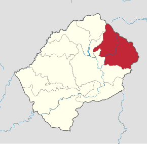
Mokhotlong er et av ti distrikter i Lesotho. Det ligger nordøst i landet og grenser til distriktene Butha-Buthe i nordvest, Leribe i vest og Thaba-Tseka i sør. Administrasjonssenteret er byen Mokhotlong. Distriktet hadde 97 713 innbyggere ved folketellingen i 2006.[1]
Distriktet var opprinnelig en del av distriktet Qacha's Nek, men ble skilt ut som eget distrikt.[2]
Referanser
- ^ 2006 Lesotho population and housing census. Volume II, Census tables report, Maseru: Ministry of Finance and Development Planning, Bureau of Statistics, 2011, s. 10. Arkivert Arkivert 5. mars 2016 hos Wayback Machine. hos DataSpace ved Princeton University.
- ^ Rosenberg, Scott og Richard F. Weisfelder: Historical Dictionary of Lesotho, 2. utgave, Lanham, MA: Scarecrow Press, 2013, s. 117.
- v
- d
- r
Lesothos distrikter
Berea · Butha-Buthe · Leribe · Mafeteng · Maseru · Mohale's Hoek · Mokhotlang · Qacha's Nek · Quthing · Thaba-Tseka

ISO 3166-2:LS
Denne artikkelen er en spire. Du kan hjelpe Wikipedia ved å utvide den.


