Villersexel
Gemeente in Frankrijk  | |||
|---|---|---|---|
 | |||
  | |||
| Situering | |||
| Regio | Bourgogne-Franche-Comté | ||
| Departement | Haute-Saône (70) | ||
| Arrondissement | Lure | ||
| Kanton | Villersexel | ||
| Coördinaten | 47° 33′ NB, 6° 26′ OL | ||
| Algemeen | |||
| Oppervlakte | 13,19 km² | ||
| Inwoners (1 januari 2021) | 1.419[1] (108 inw./km²) | ||
| Hoogte | 257 - 318 m | ||
| Overig | |||
| Postcode | 70110 | ||
| INSEE-code | 70561 | ||
| Foto's | |||
 | |||
| |||

Villersexel is een gemeente in het Franse departement Haute-Saône (regio Bourgogne-Franche-Comté) en telt 1460 inwoners (2011). De plaats maakt deel uit van het arrondissement Lure.
Geschiedenis
Slag bij Villersexel (Frans-Duitse Oorlog).
-
 Slag bij Villersexel
 -
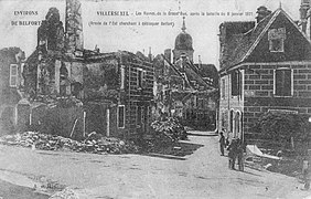 Uitzicht op de vernietiging van Bourg de Villersexel
 -
 Duitse artillerie voor de ruïnes van het kasteel van Villersexel


Geografie
De oppervlakte van Villersexel bedraagt 13,2 km², de bevolkingsdichtheid is 110,6 inwoners per km².

Demografie
Onderstaande figuur toont het verloop van het inwonertal (bron: INSEE-tellingen).

Zie ook
- Kasteel van Villersexel
Externe links
- Informatie over Villersexel
- (fr) Statistische informatie op de website van INSEE
Mediabestanden
Zie de categorie Villersexel van Wikimedia Commons voor mediabestanden over dit onderwerp.
- ↑ Populations légales 2021.


