Heinsdorfergrund

Cet article est une ébauche concernant une localité allemande.
Vous pouvez partager vos connaissances en l’améliorant (comment ?) selon les recommandations des projets correspondants.
| Heinsdorfergrund | |||
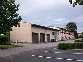 Mairie dans l'ancienne gare d'Oberheinsdorf | |||
 Armoiries | |||
| Administration | |||
|---|---|---|---|
| Pays |  Allemagne Allemagne | ||
| Land |  Saxe Saxe | ||
| District (Regierungsbezirk) | District de Chemnitz | ||
| Arrondissement (Landkreis) | Arrondissement du Vogtland | ||
| Code postal | 08468 | ||
| Indicatif téléphonique | 037600 et 03765 | ||
| Immatriculation | V | ||
| Démographie | |||
| Population | 1 945 hab. () | ||
| Densité | 89 hab./km2 | ||
| Géographie | |||
| Coordonnées | 50° 37′ 20″ nord, 12° 22′ 20″ est | ||
| Altitude | 380 m | ||
| Superficie | 2 186 ha = 21,86 km2 | ||
| Localisation | |||
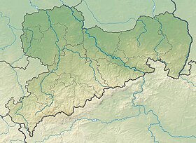
| Géolocalisation sur la carte : Allemagne
Géolocalisation sur la carte : Saxe
| |||
| Liens | |||
| Site web | www.heinsdorfergrund-vogtland.de | ||
modifier  | |||


Heinsdorfergrund (en allemand : /ˈhaɪ̯nsdɔʁfɐˌɡʁʊnt/[1],  ? Écouter [Fiche]) est une commune de Saxe (Allemagne), située dans l'arrondissement du Vogtland, dans le district de Chemnitz.
v · m Villes et communes dans l'arrondissement du Vogtland, Saxe | ||
|---|---|---|
|  | |
Références
- ↑ Prononciation en allemand standard retranscrite selon la norme API.
 Portail de la Saxe


