Wallroda Dam
Dam in Germany
Dam in Bautzen, Saxony
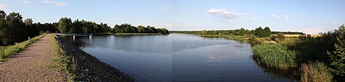
51°7′4″N 13°58′35″E / 51.11778°N 13.97639°E / 51.11778; 13.97639Wallroda Dam (German: Talsperre Wallroda) is a dam near Radeberg, Germany.
Construction
The dam was built between 1986 and 1989 in Wallroda [de] near Radeberg and south of Großröhrsdorf, with the intended purpose of supplying water to farms and fisheries in the area.[1] It also has a small part in regional flood prevention strategies.[2]
Recreational activities
Camping
A campsite can be found on the northern bank of the dam. Additionally, there are a restaurant and a miniature golf course.[3]
Swimming
There are no water rescue facilities, anyone who enters the water does so at their own risk.[1]
Fishing
The dam's reservoir is listed with the Deutscher Anglerverband (German Angling Association). For environmental protection reasons, fishing is only permitted in designated areas.[4]
See also
References
- ^ a b "Talsperre Wallroda - Infos". www.seen.de (in German). Retrieved 6 July 2020.
- ^ "Gefahrenkarte Große Röder, Los 3.2 - Arnsdorf bei Dresden" (PDF) (in German). Landestalsperrenverwaltung des Freistaates Sachsen. 22 February 2005. p. 6. Retrieved 6 July 2020.
- ^ "Home :: LuxOase". www.luxoase.de. Retrieved 6 July 2020.
- ^ "Gewässerordnung / Gewässerverzeichnis Ausgabe 2018 - 2020" (PDF) (in German). Landesanglerverband Sachsen. p. 58. Retrieved 6 July 2020.


