Vakaga
Prefecture of the Central African Republic
Prefecture in Central African Republic
Vakaga | |
|---|---|
 Vakaga, prefecture of Central African Republic | |
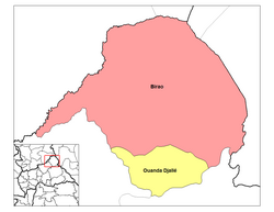 Sub-prefectures of Vakaga | |
| Country | Central African Republic |
| Capital | Birao |
| Government | |
| • Prefect | Judes Ngayakon[1] |
| Area | |
| • Total | 46,500 km2 (18,000 sq mi) |
| Population (2003 census) | |
| • Total | 52,255 |
| • Density | 1.1/km2 (2.9/sq mi) |
Vakaga is one of the 20 prefectures of the Central African Republic. Its capital is Birao.[2][3] It covers an area of 46,500 km2 and has a population of 52,255 (2003 census). The extremely low population density, 1.1 people/km2, is a result of the capture of the majority of the region's inhabitants by slave-traders from the Sudan in the second half of the nineteenth century.[citation needed] Vakaga is known for its oil reserves.[citation needed]
Notable people
- Michel Djotodia, 5th President of the Central African Republic
References
- ^ Oubangui Medias, Oubangui Medias. "Centrafrique : Décrets portant nomination des Gouverneurs, des Préfets et des Sous-Préfets". oubanguimedias.com. Oubangui Medias. Retrieved 5 June 2024.
- ^ "Population Prefecture". stat-centrafrique.com. Archived from the original on 26 June 2015. Retrieved 2 February 2012.
- ^ "Central African Republic Prefectures". statoids.com. Retrieved 2 February 2012.
- v
- t
- e
Administrative divisions of the Central African Republic
- Bamingui-Bangoran
- Bangui
- Basse-Kotto
- Haute-Kotto
- Haut-Mbomou
- Kémo
- Lobaye
- Lim-Pendé
- Mambéré
- Mambéré-Kadéï
- Mbomou
- Nana-Grébizi
- Nana-Mambéré
- Ombella-M'Poko
- Ouaka
- Ouham
- Ouham-Fafa
- Ouham-Pendé
- Sangha-Mbaéré
- Vakaga

10°20′N 22°45′E / 10.333°N 22.750°E / 10.333; 22.750
 | This Central African Republic location article is a stub. You can help Wikipedia by expanding it. |
- v
- t
- e


 Vakaga