Silambinathanpettai
Silambinathanpettai is a village and panchayat of Cuddalore district, Tamil Nadu, India, located between Cuddalore and Panruti. The village has a population of 5,000. Silambinathanpettai is located near Patthirakottai and Saathamampattu. The village is located between Cuddalore, Panruti, Neyveli depicting its position to be at heart of these triangularly positioned cities.[citation needed]
The village is known for the Cashew and Jackfruit. Silambinathanpettai has more than 500 hectares of cashew trees. The name Silambinathanpettai was said to have been coined during the 16th century due to the emergence of a number of youth with skills in the art silambam. The village pin code is 607102. Silambinathanpettai Grampanchayat villages (Silambinathanpettai, Pathirakottai, Arachekuppam, Pattikuppam, Puthukuppam, Pazhaya Pathirakottai).[citation needed]
References
- v
- t
- e
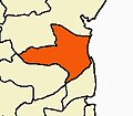
Cuddalore district
- Bhuvanagiri
- Chidambaram
- Cuddalore
- Kattumannarkoil
- Panruti
- Srimushnam
- Tittakudi
- Kurinjipadi
- Veppur
- Vriddachalam
- Annagramam
- Bhuvanagiri
- Cuddalore
- Kammapuram
- Kattumannarkoil
- Keerapalayam
- Komaratchi
- Kurinjipadi
- Mangalur
- Nallur
- Panruti
- Parangipettai
- Vriddhachalam
water
- Kollidam River
- Perumal Eri
- Ponnaiyar River(South Pennar River)
- Veeranam Lake
- Vellar River
- Wellington Lake
- Sangam period
- Kalabhras
- Pallavas
- Medieval Cholas
- Later Cholas
- Later Pandyas
- Delhi Sultanate
- Madurai Sultanate
- Vijayanagar Empire
- Nayaks of Gingee
- Nawab of the Carnatic
- Company Raj
- British Raj
- Siege of Cuddalore
- Battle of Cuddalore
the village being major producer of jackfruit, is hit by thane cyclone recently in 2011. various studies says revival from cyclone may take decades, since trees of this kind are less rigid to cyclonic wind of 125kmph.
 | This article related to a location in Cuddalore district, Tamil Nadu, India is a stub. You can help Wikipedia by expanding it. |
- v
- t
- e


