Sham Shui Po District
District in Hong Kong
Sham Shui Po 22°19′51″N 114°09′44″E / 22.33074°N 114.16220°E / 22.33074; 114.16220 | |
|---|---|
| Statutorily-defined area | Kowloon (Stonecutters' Island), New Kowloon (mainland) |
| Region | Hong Kong (special administrative region) |
| Country | China |
| Constituencies | 21 |
| Government | |
| • District Council chairman | Chum Tak Shing[needs update] (ADPL) |
| • District Council Vice-chairwoman | Janet Ng |
| • District Officer | Damian Kwok-hung Lee |
| Area | |
| • Total | 9.48 km2 (3.66 sq mi) |
| Population (2016[1]) | |
| • Total | 405,869 |
| • Density | 43,000/km2 (110,000/sq mi) |
| Time zone | UTC+8 (Hong Kong Time) |
| Largest neighbourhood by population | Sham Shui Po (60,161 – 2016 est)[2] |
| Location of district office and district council | 303 Cheung Sha Wan Road, Sham Shui Po |
| Sham Shui Po District | |||||||||||||||
|---|---|---|---|---|---|---|---|---|---|---|---|---|---|---|---|
| Traditional Chinese | 深水埗區 | ||||||||||||||
| Simplified Chinese | 深水埗区 | ||||||||||||||
| Cantonese Yale | Shāmshéuibóu kēui | ||||||||||||||
| |||||||||||||||
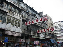
Sham Shui Po District is one of 18 districts of Hong Kong. It is the second poorest district by income in Hong Kong, with a predominantly working-class population of 405,869 in 2016 and the lowest median household income of all districts.[3] Sham Shui Po has long been home to poorer new immigrants from China. It also saw the birth of public housing in Hong Kong, as the government sought to resettle those displaced by a devastating fire in its slums. Sham Shui Po also hosted a Vietnamese refugee camp during the influx of migration in the aftermath of the Vietnam War in the 1970s.
The district covers the Shek Kip Mei, Sham Shui Po, Cheung Sha Wan, Lai Chi Kok, Kowloon Tsai,[clarify] So Uk, Un Chau [yue], Tai Wo Ping [yue] and Yau Yat Chuen areas of New Kowloon, and Stonecutters Island of Kowloon.
Administration
Sham Shui Po District administers:
- Cheung Sha Wan – Between Tonkin Street and Kom Tsun Street / Butterfly Valley Road.
- Western Part of Kowloon Tong – West of the route of East Rail line, north of Boundary Street and east of Tai Hang Tung Road
- Sham Shui Po – Between Tonkin Street and Boundary Street
- Shek Kip Mei – East of Tai Po Road, North of Boundary Street, west of Tai Hang Tung Road.
- So Uk – Between Po On Road and Ching Cheung Road / Tai Po Road.
- Stonecutters Island – Excluding the reclaimed lands for Container Terminal 8 which is located in north of Hing Wah Street West and Ngong Shuen Chau Viaduct.
Demographics and housing


Sham Shui Po was already a densely populated district in the 1950s and 1960s. It is poverty-stricken, having the lowest median monthly domestic household income among the 18 districts. It has the highest percentage of elderly people over 65 years. The percentage of new immigrants is also very high. Living conditions of grass-roots families in this district remain a social issue.[4]
Mei Foo Sun Chuen in Lai Chi Kok, built in 1968–1978, was Hong Kong's first large-scale private housing estate. It comprises eight phases with a total of 99 blocks.[5]
Public Housing
There are 18 public housing estates in the Sham Shui Po District, divided into sub-districts:
- Cheung Sha Wan
- Cheung Sha Wan Estate
- Fortune Estate
- Hoi Lai Estate
- Hoi Tat Estate
- Hoi Ying Estate
- Lai Tsui Court
- Lei Cheng Uk Estate
- So Uk Estate
- Un Chau Estate
- Sham Shui Po
- Shek Kip Mei
Education
The main campus of City University of Hong Kong, was located in Tat Chee Avenue,[6] Sham Shui Po District.[7]
Transport
There are four railway lines serving Sham Shui Po District:
MTR

- Kwun Tong line: Shek Kip Mei
- Tsuen Wan line: Sham Shui Po, Cheung Sha Wan, Lai Chi Kok, Mei Foo.
- Tung Chung line: Nam Cheong.
- Tuen Ma line: Mei Foo, Nam Cheong.
Buses
There are also various bus routes serving the district. Most of them are operated by Kowloon Motor Bus, and some by Citybus. These two companies also jointly operate some routes, most of these crossing the harbour to the Hong Kong Island.
- Kowloon Motor Bus: 1, 1A, 2, 2A, 2B, 2D, 2E, 2F, 2X, 6, 6C, 6D, 6F, 6P, 6X, 12, 12A, 12P, 13P, 18, 30, 30X, 31B, 32, 33, 33A, 33B, 35A, 35X, 36A, 36B, 36X, 37, 38, 38A, 38P, 40, 40A, 40P, 42, 42A, 42C, 43C, 44, 45, 46, 46X, 52X, 58X, 59X, 60X, 61X, 62P, 62X, 63X, 66X, 67X, 68X, 69C, 69X, 72, 81, 86, 86A, 86C, 87B, 87D, 87E, 98C, 98S, 203C, 203S, 214, 214P, 230X, 234C, 234D, 234X, 238X, 240X, 242X, 252X, 258A, 258D, 258P, 258S, 259C, 259D, 265B, 268A, 268C, 269C, 270B, 270D, 272E, 272P, 281A, 286C, 286P, 286X, 290, 290A, 290B, 290E, 290X, 296C, 296P, 298C, 298X, N214, N273, N241, N252, N260, N269, N290, X6C, X42C
- Citybus: 20, 20A, 50, 55, 79P, 79X, 701, 701A, 701S, 702, 702A, 702B, 702S, 793, 795, 795P, 795X, A20, A21, A23, A26, A26P, A29, A29P, E21, E21A, E21C, E22, E22A, E22C, E22P, E22S, E22X, N21, N21A, N26, N29, NA20, NA29
- Cross Harbour Tunnel: 102, 102P, 102R, 104, 112, 117, 118, 118P, 171, 171A, 171P, 904, 905, 905A, 905P, 914, 914P, 914X, 936, 936A, 970, 970X, 971, N118, N122, N171, N368, X970
See also
References
- ^ "2016 Population Census: Summary Results Table A201a Population by District Council District and Year" (in English and Chinese). Census and Statistics Department, Hong Kong Government. 2016. Retrieved 24 May 2018.
- ^ District Profiles, Hong Kong Government, 8 December 2017, retrieved 15 April 2020
- ^ Basic Tables for District Council Districts: Hong Kong 2006 By-Census
- ^ "Living conditions in city's poorest district getting worse". South China Morning Post. 23 April 2017. Retrieved 5 June 2020.
- ^ "The birth of Hong Kong's middle class: Mei Foo Sun Chuen, the first private housing estate". South China Morning Post. Retrieved 5 June 2020.
- ^ "City University of Hong Kong". City University of Hong Kong. Retrieved 5 June 2020.
- ^ "District Council Constituency Boundaries - Sham Shui Po District" (PDF). Hong Kong: Electoral Affairs Commission. January 2015. Retrieved 5 April 2019.
External links
Wikimedia Commons has media related to Sham Shui Po District.
- Sham Shui Po District Council
- List and map of electoral constituencies
- v
- t
- e
Places adjacent to Sham Shui Po District


| |
|---|---|
| |
| Hong Kong Island | |
| Kowloon and New Kowloon |
|
| New Territories (excluding New Kowloon) | |

Urban areas of Hong Kong, Kowloon and New Territories | |||||||||
|---|---|---|---|---|---|---|---|---|---|
| Hong Kong1,3,4,5,6,7,8,9a,10,11,12 |  | ||||||||
| KowloonKL,1,2,3,4,5,6,7,8,9a,10,11,12 |
| ||||||||
| New KowloonNKL,2,3,4,5,6,7,9a,10,11,12 |
| ||||||||
| New Territories |
| ||||||||
Official place names are summarized from "Geoinfo Map" of Government of Hong Kong Special Administrative Region, "Hong Kong Guide" of Lands Department, "Hong Kong Guide Book" of Universal Publications Ltd. and "Areas and Districts" of Rating and Valuation Department. KL: Kowloon Peninsula at the south of Boundary Street NKL: Former New Territories area at the north of Boundary Street and at the south of Lion Rock 1: Common definition (1) 2: Common definition (2) 3: Common definition (3) 4: Areas not adopting small house concessionary right of indigenous inhabitants 5: Jurisdiction area of former Urban Council 6: Definition of "Metropolitan Area" of Planning Department 7: Jurisdiction area of Urban Renewal Authority 8: Unique operating area of urban taxis 9: "Urban" (9a) and "Extended Urban" (9b) areas defined by Hong Kong Housing Authority 10: Definition of Urban rates 11: Hospital cluster belongs to Hong Kong or Kowloon 12: Police region belongs to Hong Kong or Kowloon 13: Regions having 999-year land lease | |||||||||


