Pleasant Valley, Rockingham County, Virginia
Unincorporated community in Virginia, United States
38°23′05″N 78°53′50″W / 38.38472°N 78.89722°W / 38.38472; -78.89722Pleasant Valley is an unincorporated community in Rockingham County, Virginia, United States.
Geography
Pleasant Valley is located 4.7 miles (7.6 km) south-southeast of Harrisonburg, Virginia.[2]
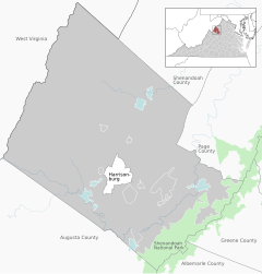

Pleasant Valley
class=notpageimage|
Location of Pleasant Valley within the Rockingham CountyReferences
- ^ "Pleasant Valley". Geographic Names Information System. United States Geological Survey, United States Department of the Interior. Retrieved August 1, 2013.
- ^ "Pleasant Valley, Rockingham County, Virginia" (Map). Google Maps. Retrieved August 1, 2013.
- v
- t
- e
Municipalities and communities of Rockingham County, Virginia, United States
County seat: Harrisonburg
- Bridgewater
- Broadway
- Dayton
- Elkton
- Grottoes‡
- Mount Crawford
- Timberville

communities
- Bergton
- Berrytown
- Briery Branch
- Clover Hill
- Cootes Store
- Criders
- Cross Keys
- Dale Enterprise
- Edom
- Fulks Run
- Hinton
- Inglewood
- Lacey Spring
- Lilly
- Mauzy
- Mayland
- Mechanicsville
- Montezuma
- Mount Clinton
- New Erection
- Ottobine
- Penn Laird
- Pleasant Valley
- Rawley Springs
- Stemphleytown
- Tenth Legion
- Turleytown
- Yankeetown
‡This populated place also has portions in an adjacent county or counties
- Virginia portal
- United States portal
 | This Rockingham County, Virginia state location article is a stub. You can help Wikipedia by expanding it. |
- v
- t
- e


