Oretta, Louisiana
Census-designated place in Louisiana, United States
30°31′32″N 93°26′13″W / 30.52556°N 93.43694°W / 30.52556; -93.43694[1]
(2020)
Oretta is a census-designated place in Beauregard Parish, Louisiana, United States.[2] As of the 2010 census, it had a population of 418.[3]
Geography
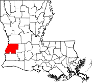
Oretta is located in southern Beauregard Parish at 30°31′32″N 93°26′13″W / 30.52556°N 93.43694°W / 30.52556; -93.43694. Louisiana Highway 27 leads through the center of the CDP, leading north 25 miles (40 km) to DeRidder, the parish seat, and south 5 miles (8 km) to DeQuincy in Calcasieu Parish.
According to the United States Census Bureau, the Oretta CDP has a total area of 2.2 square miles (5.7 km2), all land.[3]
Demographics
| Census | Pop. | Note | %± |
|---|---|---|---|
| 2020 | 371 | — | |
| U.S. Decennial Census[4] | |||
References
- ^ "2020 U.S. Gazetteer Files". United States Census Bureau. Retrieved March 20, 2022.
- ^ U.S. Geological Survey Geographic Names Information System: Oretta, Louisiana
- ^ a b "Geographic Identifiers: 2010 Demographic Profile Data (G001): Oretta CDP, Louisiana". U.S. Census Bureau, American Factfinder. Archived from the original on February 12, 2020. Retrieved November 27, 2013.
- ^ "Census of Population and Housing". Census.gov. Retrieved June 4, 2016.
- v
- t
- e
Municipalities and communities of Beauregard Parish, Louisiana, United States
Parish seat: DeRidder
communities
- Abbie Joe
‡This populated place also has portions in an adjacent parish or parishes
- Louisiana portal
- United States portal
 | This Louisiana state location article is a stub. You can help Wikipedia by expanding it. |
- v
- t
- e


