Orahovica, Konjic
Village in Federation of Bosnia and Herzegovina, Bosnia and Herzegovina
Orahovica Ораховица | |
|---|---|
Village | |
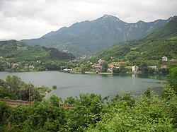 View of Orahovica Konjic | |
| 43°40′14″N 17°54′57″E / 43.67056°N 17.91583°E / 43.67056; 17.91583 | |
| Country |  Bosnia and Herzegovina Bosnia and Herzegovina |
| Entity | Federation of Bosnia and Herzegovina |
| Canton |  Herzegovina-Neretva Herzegovina-Neretva |
| Municipality |  Konjic Konjic |
| Area | |
| • Total | 4.02 sq mi (10.41 km2) |
| Elevation | 1,667 ft (508 m) |
| Population (2013) | |
| • Total | 570 |
| • Density | 140/sq mi (55/km2) |
| Time zone | UTC+1 (CET) |
| • Summer (DST) | UTC+2 (CEST) |
Orahovica (Cyrillic: Ораховица) is a village in the municipality of Konjic, Bosnia and Herzegovina.[1]
Demographics
According to the 2013 census, its population was 570.[2]
| Ethnicity | Number | Percentage |
|---|---|---|
| Bosniaks | 514 | 90.2% |
| Croats | 53 | 9.3% |
| Serbs | 2 | 0.4% |
| other/undeclared | 1 | 0.2% |
| Total | 570 | 100% |
References
- ^ Official results from the book: Ethnic composition of Bosnia-Herzegovina population, by municipalities and settlements, 1991. census, Zavod za statistiku Bosne i Hercegovine - Bilten no.234, Sarajevo 1991.
- ^ "Naseljena Mjesta 1991/2013" (in Bosnian). Statistical Office of Bosnia and Herzegovina. Retrieved October 3, 2021.
- v
- t
- e
Settlements of Konjic
- Argud
- Bale
- Bare
- Barmiš
- Bijela
- Bjelovčina
- Blace
- Blučići
- Borci
- Boždarevići
- Bradina
- Brđani
- Budišnja Ravan
- Bukovica
- Bukovlje
- Bulatovići
- Bušćak
- Buturović Polje
- Čelebići
- Čelina
- Cerići
- Česim
- Čičevo
- Crni Vrh
- Čuhovići
- Dobričevići
- Dolovi
- Doljani
- Donja Vratna Gora
- Donje Selo
- Donje Višnjevice
- Donji Čažanj
- Donji Gradac
- Donji Nevizdraci
- Donji Prijeslop
- Došćica
- Dubočani
- Dubravice
- Dudle
- Dužani
- Džajići
- Džanići
- Džepi
- Falanovo Brdo
- Gakići
- Galjevo
- Glavatičevo
- Gobelovina
- Gorani
- Goransko Polje
- Gorica
- Gornja Vratna Gora
- Gornje Višnjevice
- Gornji Čažanj
- Gornji Gradac
- Gornji Nevizdraci
- Gostovići
- Grabovci
- Gradeljina
- Grušča
- Hasanovići
- Herići
- Homatlije
- Homolje
- Hondići
- Idbar
- Jasenik
- Javorik
- Ježeprosina
- Jezero
- Jošanica
- Kale
- Kanjina
- Kašići
- Konjic
- Kostajnica
- Koto
- Krajkovići
- Kralupi
- Krtići
- Krupac
- Krušćica
- Kula
- Lađanica
- Lisičići
- Ljesovina
- Ljubuča
- Ljuta
- Lokva
- Luka
- Lukomir
- Lukšije
- Mladeškovići
- Mokro
- Mrkosovice
- Obrenovac
- Obri
- Odžaci
- Orahovica
- Orlište
- Oteležani
- Ovčari
- Pačerani
- Parsovići
- Plavuzi
- Podhum
- Podorašac
- Pokojište
- Polje Bijela
- Požetva
- Prevlje
- Radešine
- Raotići
- Rasvar
- Razići
- Redžići
- Repovci
- Repovica
- Ribari
- Ribići
- Seljani
- Seonica
- Sitnik
- Slavkovići
- Solakova Kula
- Sopot
- Spiljani
- Stojkovići
- Strgonice
- Studenčica
- Sultići
- Šunji
- Svijenča
- Tinje
- Tovarnica
- Treboje
- Trešnjevica
- Trusina
- Tuhobići
- Turija
- Ugošće
- Veluša
- Vinište
- Vrbljani
- Vrci
- Vrdolje
- Zabrđani
- Zabrđe
- Zagorice
- Zaslivlje
- Zukići
43°40′13″N 17°54′55″E / 43.6703°N 17.9153°E / 43.6703; 17.9153
 | This Herzegovina-Neretva Canton geography article is a stub. You can help Wikipedia by expanding it. |
- v
- t
- e


