Ochakovo-Matveyevskoye District
District in Moscow, Russia
Ochakovo-Matveevskoe район Очаково-Матвевское | |
|---|---|
District | |
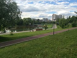 Nikulpool, Ochakovo-Matveyevskoye District | |
 Flag  Coat of arms | |
 Location of Ochakovo-Matveevskoe on the map of Moscow | |
| Coordinates: 55°41′39″N 37°26′38″E / 55.69417°N 37.44389°E / 55.69417; 37.44389 | |
| Country | Russia |
| Federal subject | Moscow |
| Area [1] | |
| • Total | 17.544 km2 (6.774 sq mi) |
| Population | |
| • Estimate (2022)[1] | 129,002 |
| Time zone | UTC+3 (MSK |
| OKTMO ID | 45323000 |
| Website | http://ochakovo.mos.ru/ |
Ochakovo-Matveevskoe (Russian: Очаково-Матвеевское райо́н) is an administrative district (raion) of Western Administrative Okrug, and one of the 125 raions of Moscow, Russia.[3] The area of the district is 17.5436 square kilometers (6.7736 sq mi).[1] Population: 129,002 (2022 est.). It was formed in 1997 through merging of the Ochakovo and Matveevskoe districts.
See also
References
Notes
- ^ a b c "General Information" (in Russian). Ochakovo-Matveyevskoye District. Retrieved April 12, 2018.
- ^ "Об исчислении времени". Официальный интернет-портал правовой информации (in Russian). 3 June 2011. Retrieved 19 January 2019.
- ^ Государственный комитет Российской Федерации по статистике. Комитет Российской Федерации по стандартизации, метрологии и сертификации. №ОК 019-95 1 января 1997 г. «Общероссийский классификатор объектов административно-территориального деления. Код 45», в ред. изменения №278/2015 от 1 января 2016 г.. (State Statistics Committee of the Russian Federation. Committee of the Russian Federation on Standardization, Metrology, and Certification. #OK 019-95 January 1, 1997 Russian Classification of Objects of Administrative Division (OKATO). Code 45, as amended by the Amendment #278/2015 of January 1, 2016. ).
Sources
- v
- t
- e
- Arbat
- Basmanny
- Khamovniki
- Krasnoselsky
- Meshchansky
- Presnensky
- Tagansky
- Tverskoy
- Yakimanka
- Zamoskvorechye
- Filimonkovsky
- Kommunarka
- Vnukovo
- Shcherbinka
- Bekasovo
- Krasnopakhorsky
- Troitsk
- Voronovo
55°41′39″N 37°26′38″E / 55.69417°N 37.44389°E / 55.69417; 37.44389
 | This Moscow location article is a stub. You can help Wikipedia by expanding it. |
- v
- t
- e


