Noxen, Pennsylvania
Census-designated place in Pennsylvania, United States
Noxen, Pennsylvania | |
|---|---|
census-designated place | |
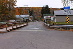 Main street in Noxen | |
| Country | United States |
| State | Pennsylvania |
| County | Wyoming |
| Area [1] | |
| • Total | 1.99 sq mi (5.16 km2) |
| • Land | 1.98 sq mi (5.13 km2) |
| • Water | 0.01 sq mi (0.03 km2) |
| Population (2020)[2] | |
| • Total | 643 |
| • Density | 324.42/sq mi (125.28/km2) |
| Time zone | UTC-5 (Eastern (EST)) |
| • Summer (DST) | UTC-4 (EDT) |
| ZIP code | 18636[3] |
| Area code(s) | 272 and 570 |
| FIPS code | 42-55728 |
| Website | www |
Noxen is a census-designated place[4] that is located in Noxen Township, Wyoming County in the Commonwealth of Pennsylvania in the United States.
This community is situated close to Pennsylvania Route 29, approximately 10 miles (16 km) west of Scranton.
Demographics
As of the 2010 census[5] its population was 633 residents.
| Census | Pop. | Note | %± |
|---|---|---|---|
| 2020 | 643 | — | |
| U.S. Decennial Census[6] | |||
Gallery
-
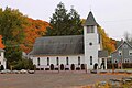 Church in Noxen
 -
 Schooley's Peak with wind turbine near Noxen


References
- ^ "ArcGIS REST Services Directory". United States Census Bureau. Retrieved October 12, 2022.
- ^ "Census Population API". United States Census Bureau. Retrieved October 12, 2022.
- ^ "Noxen PA ZIP Code". zipdatamaps.com. 2023. Retrieved October 31, 2023.
- ^ Noxen 2010 Census Information
- ^ 2010 US Census
- ^ "Census of Population and Housing". Census.gov. Retrieved June 4, 2016.
- v
- t
- e
Municipalities and communities of Wyoming County, Pennsylvania, United States
County seat: Tunkhannock

- Lake Winola
- Mehoopany
- Noxen
- Stull
- West Falls
communities
- Pennsylvania portal
- United States portal
41°25′45″N 76°03′46″W / 41.42917°N 76.06278°W / 41.42917; -76.06278
 | This Wyoming County, Pennsylvania state location article is a stub. You can help Wikipedia by expanding it. |
- v
- t
- e


