North Charlestown Historic District
Historic district in New Hampshire, United States
United States historic place
North Charlestown Historic District | |
 | |
43°18′39.0″N 72°23′16.4″W / 43.310833°N 72.387889°W / 43.310833; -72.387889 | |
| Area | 50 acres (20 ha) |
|---|---|
| Architectural style | Colonial, Mid 19th Century Revival |
| NRHP reference No. | 05000568[1] |
| Added to NRHP | June 9, 2005 |
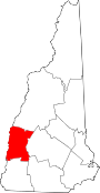
The North Charlestown Historic District encompasses a 19th-century rural village in Charlestown, New Hampshire. Located about 5 miles (8 km) north of the town's center, the district includes a small cluster of buildings along New Hampshire Route 12A (River Road) that is a remnant portion of a larger agricultural village. First settled in the 1750s, the oldest buildings in the district date to the 1790s, and most of the major buildings were built in the 19th century. Its economy was based on lumber (supported by a mill on the Little Sugar River) and farming. The village was once considered a much larger, dispersed settlement, but construction of New Hampshire Route 11 in the 1960s separated some of the more remote parts of the village from its nucleus, which was bypassed by that construction.[2]
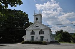
The district was listed on the National Register of Historic Places in 2005.[1] It extends along NH 12A from its junction with Ox Brook Rooad south to the Little Sugar River, just north of its junction with Depot Hill Road. Notable buildings include the 1841 Greek Revival Methodist Church, the Union Hall/Grange Hall built in 1888, and the Farwell School, a stone building erected in 1889. Most of the district's buildings are wood-frame houses, although there are two of brick. Stylistically, they are typically vernacular expressions of Federal and Greek Revival architecture, although examples of Italianate and Second Empire architecture are also to be seen. The district also includes ruinous mill remnants on the Little Sugar River.[2]
See also
References
- ^ a b "National Register Information System". National Register of Historic Places. National Park Service. July 9, 2010.
- ^ a b "NRHP nomination for North Charlestown Historic District". National Park Service. Retrieved July 14, 2014.
- v
- t
- e
- Central Business District
- Charlestown Main Street Historic District
- Lower Village District
- Monadnock Mills
- Newport Downtown Historic District
- North Charlestown Historic District
- Washington Common Historic District
- Acworth Silsby Library
- Backside Inn
- Blow-Me-Down Grange
- Charlestown Town Hall
- Claremont City Hall
- Claremont Warehouse No. 34
- Farwell School
- Little Red School House 1835 District No. 7
- Meriden Town Hall
- Mothers' and Daughters' Club House
- Plainfield Town Hall
- Protectworth Tavern
- Richards Free Library
- Richards, Dexter, & Sons Woolen Mill
- Sullivan County Courthouse
- Town Hall and Courthouse
- Unity Town Hall
- Burford House
- Capt. John Gunnison House
- Cote House
- Covit House
- David Dexter House
- Durham House
- Garber House
- Giffin House
- Isaac Reed House
- Janicke House
- Knights-Morey House
- Lear House
- Louis St. Gaudens House and Studio
- Nettleton House
- Pike House
- Purnell House
- Scranton House
- Seavey House
- Stelljes House
- Welcome Acres
- William Rossiter House
- Williamson House
- Windswept Acres-Powers House
worship
- Acworth Congregational Church
- English Church
- First Baptist Church of Cornish
- First Universalist Chapel
- Langdon Meeting House
- Lempster Meetinghouse
- South Congregational Church
- Springfield Town Hall and Howard Memorial Methodist Church
- Trinity Church
‡ This historic property also has portions in an adjacent state.
Entries in italics have been removed from the register.
Entries in italics have been removed from the register.


