Ngọc Hiển district
You can help expand this article with text translated from the corresponding article in Vietnamese. (March 2009) Click [show] for important translation instructions.
- View a machine-translated version of the Vietnamese article.
- Machine translation, like DeepL or Google Translate, is a useful starting point for translations, but translators must revise errors as necessary and confirm that the translation is accurate, rather than simply copy-pasting machine-translated text into the English Wikipedia.
- Do not translate text that appears unreliable or low-quality. If possible, verify the text with references provided in the foreign-language article.
- You must provide copyright attribution in the edit summary accompanying your translation by providing an interlanguage link to the source of your translation. A model attribution edit summary is
Content in this edit is translated from the existing Vietnamese Wikipedia article at [[:vi:Ngọc Hiển]]; see its history for attribution. - You may also add the template
{{Translated|vi|Ngọc Hiển}}to the talk page. - For more guidance, see Wikipedia:Translation.
District in Cà Mau, Vietnam
Ngọc Hiển district Huyện Ngọc Hiển | |
|---|---|
 | |
| Seal | |
 Districts of Cà Mau province | |
 | |
| Country |  Vietnam Vietnam |
| Province | Cà Mau |
| Founded | 1984: renamed from Năm Căn district |
| Capital | Viên An Đông |
| Area | |
| • District | 287 sq mi (743 km2) |
| Population (2019 census) | |
| • District | 66,874 |
| • Density | 230/sq mi (90/km2) |
| • Urban | 11,498 |
| • Rural | 55,376 |
| Time zone | UTC+07:00 (Indochina Time) |
| Website | ngochien |
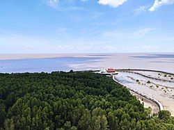
Ngọc Hiển is the southernmost rural district of Cà Mau province in the Mekong Delta region of Vietnam. As of 2003 the district had a population of 66,874.[1][2] The district covers an area of 743 km2. The district capital lies at Viên An Đông.[2]
Divisions
The district is divided into the following communes:
- Rạch Gốc (urban municipality)
- Đất Mũi
- Tam Giang Tây
- Tân Ân
- Tân Ân Tây
- Viên An
- Viên An Đông
References
- ^ "Ngọc Hiển (District, Cà Mau, Vietnam) – Population Statistics, Charts, Map and Location". www.citypopulation.de. Retrieved 2024-02-07.
- ^ a b "Districts of Vietnam". Statoids. Retrieved March 13, 2009.
8°40′01″N 105°00′00″E / 8.667°N 105.000°E / 8.667; 105.000
- v
- t
- e
Districts of the Mekong Delta

- Cao Lãnh city※
- Hồng Ngự city
- Sa Đéc city
- Cao Lãnh
- Châu Thành
- Hồng Ngự
- Lai Vung
- Lấp Vò
- Tân Hồng
- Tam Nông
- Thanh Bình
- Tháp Mười
- Ngã Bảy city
- Vị Thanh city※
- Long Mỹ town
- Châu Thành
- Châu Thành A
- Long Mỹ
- Phụng Hiệp
- Vị Thủy
- Mỹ Tho city※
- Cai Lậy town
- Gò Công town
- Cái Bè
- Cai Lậy
- Châu Thành
- Chợ Gạo
- Gò Công Đông
- Gò Công Tây
- Tân Phú Đông
- Tân Phước
※ denotes provincial seat.
 | This article about a location in Cà Mau province, Vietnam is a stub. You can help Wikipedia by expanding it. |
- v
- t
- e


