National Register of Historic Places listings in Smithfield, Rhode Island
This is a list of Registered Historic Places in Smithfield, Rhode Island.
| Bristol | Kent | Newport | Providence | Washington |
This National Park Service list is complete through NPS recent listings posted September 13, 2024.[1]
Map all coordinates using OpenStreetMap
Download coordinates as:
- KML
- GPX (all coordinates)
- GPX (primary coordinates)
- GPX (secondary coordinates)
| [2] | Name on the Register[3] | Image | Date listed[4] | Location | City or town | Description |
|---|---|---|---|---|---|---|
| 1 | Allenville Mill Storehouse |  | January 20, 1972 (#72000033) | 5 Esmond St. 41°52′41″N 71°30′09″W / 41.878056°N 71.5025°W / 41.878056; -71.5025 (Allenville Mill Storehouse) | Smithfield | |
| 2 | Angell–Ballou House |  | March 18, 2004 (#04000196) | 49 Ridge Rd. 41°53′42″N 71°30′05″W / 41.895°N 71.501389°W / 41.895; -71.501389 (Angell–Ballou House) | Smithfield | |
| 3 | Georgiaville Historic District | 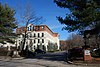 | October 3, 1985 (#85002734) | Roughly bounded by Stillwater Rd., Cross St., Whipple Ave., and Farnum Pike 41°53′18″N 71°30′26″W / 41.888333°N 71.507222°W / 41.888333; -71.507222 (Georgiaville Historic District) | Smithfield | |
| 4 | Saint Thomas Episcopal Church and Rectory | 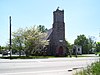 | July 2, 1987 (#87000993) | Putnam Pike 41°52′16″N 71°33′12″W / 41.871111°N 71.553333°W / 41.871111; -71.553333 (Saint Thomas Episcopal Church and Rectory) | Smithfield | |
| 5 | Smith–Appleby House | 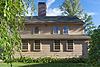 | May 1, 1974 (#74000005) | Stillwater Rd. southeast of its junction with Capron Rd. 41°54′07″N 71°31′06″W / 41.901944°N 71.518333°W / 41.901944; -71.518333 (Smith–Appleby House) | Smithfield | |
| 6 | Smithfield Exchange Bank | 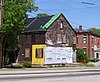 | April 19, 2006 (#06000295) | 599 Putnam Pike 41°52′26″N 71°33′12″W / 41.873889°N 71.553333°W / 41.873889; -71.553333 (Smithfield Exchange Bank) | Smithfield | |
| 7 | Ira B. Sweet House |  | January 15, 2010 (#08000715) | 38 Esmond St. 41°52′31″N 71°30′13″W / 41.875369°N 71.503639°W / 41.875369; -71.503639 (Ira B. Sweet House) | Smithfield | |
| 8 | Waterman–Winsor Farm |  | June 27, 1980 (#80000012) | 79 Austin Ave. 41°52′55″N 71°33′45″W / 41.881944°N 71.5625°W / 41.881944; -71.5625 (Waterman–Winsor Farm) | Smithfield | |
| 9 | Stephen Winsor House |  | October 6, 1975 (#75000004) | 113 Austin Ave. 41°53′08″N 71°33′55″W / 41.885502°N 71.565378°W / 41.885502; -71.565378 (Stephen Winsor House) | Smithfield | Listed at 93 Austin Ave. |
| 10 | Woonasquatucket River Site (RI-163) |  | November 1, 1984 (#84000364) | near Farnum Pike[5] 41°54′33″N 71°32′21″W / 41.90924°N 71.539285°W / 41.90924; -71.539285 (Woonasquatucket River Site (RI-163)) | Smithfield |
See also
- National Register of Historic Places listings in Providence County, Rhode Island
- List of National Historic Landmarks in Rhode Island
References
- ^ National Park Service, United States Department of the Interior, "National Register of Historic Places: Weekly List Actions", retrieved September 13, 2024.
- ^ Numbers represent an alphabetical ordering by significant words. Various colorings, defined here, differentiate National Historic Landmarks and historic districts from other NRHP buildings, structures, sites or objects.
- ^ "National Register Information System". National Register of Historic Places. National Park Service. March 13, 2009.
- ^ The eight-digit number below each date is the number assigned to each location in the National Register Information System database, which can be viewed by clicking the number.
- ^ "Smithfield Reconnaissance Report" (PDF). National Park Service. Retrieved 2013-11-02.
- v
- t
- e

| Bristol County | |
|---|---|
| Kent County | |
| Newport County | |
| Providence County | |
| Washington County |
 Category
 NRHP portal
- Rhode Island portal


