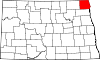
National Register of Historic Places listings in Pembina County, North Dakota

This is a list of the National Register of Historic Places listings in Pembina County, North Dakota.
This is intended to be a complete list of the properties and districts on the National Register of Historic Places in Pembina County, North Dakota, United States. The locations of National Register properties and districts for which the latitude and longitude coordinates are included below, may be seen in a map.[1]
There are 13 properties and districts listed on the National Register in the county.
Map all coordinates using OpenStreetMap
Download coordinates as:
- KML
- GPX (all coordinates)
- GPX (primary coordinates)
- GPX (secondary coordinates)
| Adams | Barnes | Benson | Billings | Bottineau | Bowman | Burke | Burleigh | Cass | Cavalier | Dickey | Divide | Dunn | Eddy | Emmons | Foster | Golden Valley | Grand Forks | Grant | Griggs | Hettinger | Kidder | LaMoure | Logan | McHenry | McIntosh | McKenzie | McLean | Mercer | Morton | Mountrail | Nelson | Oliver | Pembina | Pierce | Ramsey | Ransom | Renville | Richland | Rolette | Sargent | Sheridan | Sioux | Slope | Stark | Steele | Stutsman | Towner | Traill | Walsh | Ward | Wells | Williams |
This National Park Service list is complete through NPS recent listings posted September 13, 2024.[2]
Current listings
| [3] | Name on the Register | Image | Date listed[4] | Location | City or town | Description |
|---|---|---|---|---|---|---|
| 1 | Crystal Bridge | Upload image | May 30, 1997 (#97000507) | Appleton Ave. over Cart Creek 48°35′49″N 97°40′20″W / 48.596944°N 97.672222°W / 48.596944; -97.672222 (Crystal Bridge) | Crystal | |
| 2 | Dease-Martineau House, Trading Post and Oxcart Trail Segments | Upload image | December 22, 2017 (#100001744) | 13565 105th St. NE. 48°56′05″N 97°44′09″W / 48.934647°N 97.735728°W / 48.934647; -97.735728 (Dease-Martineau House, Trading Post and Oxcart Trail Segments) | Leroy vicinity | |
| 3 | Drayton United Methodist Church | 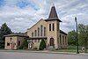 | December 10, 1979 (#79001773) | ND 44 48°33′48″N 97°10′37″W / 48.563333°N 97.176944°W / 48.563333; -97.176944 (Drayton United Methodist Church) | Drayton | |
| 4 | Gingras House and Trading Post |  | May 21, 1975 (#75001305) | Northeast of Walhalla off ND 32 48°56′13″N 97°53′26″W / 48.936944°N 97.890556°W / 48.936944; -97.890556 (Gingras House and Trading Post) | Walhalla | |
| 5 | Grace Episcopal Church |  | September 2, 1994 (#94001075) | 152 Ramsey St., W. 48°57′57″N 97°14′45″W / 48.965833°N 97.245833°W / 48.965833; -97.245833 (Grace Episcopal Church) | Pembina | |
| 6 | Gunlogson Farmstead Historic Site | 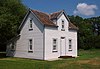 | September 18, 2008 (#08000232) | 13571 ND 5 48°46′22″N 97°44′06″W / 48.772778°N 97.734928°W / 48.772778; -97.734928 (Gunlogson Farmstead Historic Site) | Cavalier | |
| 7 | Icelandic Evangelical Lutheran Church | 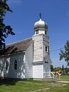 | December 5, 2019 (#100004714) | 415 Beaupre St. (aka Adelaide St.) 48°57′43″N 97°14′35″E / 48.962050°N 97.242929°E / 48.962050; 97.242929 (Icelandic Evangelical Lutheran Church) | Pembina | Onion-domed church |
| 8 | O'Connor House | Upload image | July 3, 1980 (#80004544) | Off U.S. Route 81 48°36′57″N 97°26′54″W / 48.615833°N 97.448333°W / 48.615833; -97.448333 (O'Connor House) | St. Thomas | |
| 9 | Pembina County Courthouse | 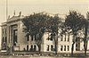 | November 25, 1980 (#80002923) | 301 Dakota Street W 48°47′28″N 97°37′31″W / 48.791111°N 97.625278°W / 48.791111; -97.625278 (Pembina County Courthouse) | Cavalier | |
| 10 | Ridge Trail Historic District |  | March 17, 2006 (#05001333) | Address Restricted | Kensington | Historic trail segments in Walsh and Pembina Counties. |
| 11 | US Customs House and Post Office-Pembina | 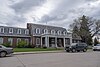 | November 1, 1989 (#89001755) | 125 S. Cavalier St. 48°57′59″N 97°14′39″W / 48.966389°N 97.244167°W / 48.966389; -97.244167 (US Customs House and Post Office-Pembina) | Pembina | |
| 12 | Vikur Lutheran Church at Mountain | 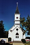 | November 7, 2013 (#13000862) | 290 Main Ave. 48°40′52″N 97°51′54″W / 48.68108°N 97.864871°W / 48.68108; -97.864871 (Vikur Lutheran Church at Mountain) | Mountain | |
| 13 | Walla Theater | 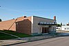 | May 17, 2010 (#10000266) | 909 Central Ave. 48°55′19″N 97°55′00″W / 48.921822°N 97.91675°W / 48.921822; -97.91675 (Walla Theater) | Walhalla |
See also
Wikimedia Commons has media related to National Register of Historic Places in Pembina County, North Dakota.
- List of National Historic Landmarks in North Dakota
- National Register of Historic Places listings in North Dakota
References
- ^ The latitude and longitude information provided in this table was derived originally from the National Register Information System, which has been found to be fairly accurate for about 99% of listings. Some locations in this table may have been corrected to current GPS standards.
- ^ National Park Service, United States Department of the Interior, "National Register of Historic Places: Weekly List Actions", retrieved September 13, 2024.
- ^ Numbers represent an alphabetical ordering by significant words. Various colorings, defined here, differentiate National Historic Landmarks and historic districts from other NRHP buildings, structures, sites or objects.
- ^ The eight-digit number below each date is the number assigned to each location in the National Register Information System database, which can be viewed by clicking the number.
- v
- t
- e

by county
- Adams
- Barnes
- Benson
- Billings
- Bottineau
- Bowman
- Burke
- Burleigh
- Cass
- Cavalier
- Dickey
- Divide
- Dunn
- Eddy
- Emmons
- Foster
- Golden Valley
- Grand Forks
- Grant
- Griggs
- Hettinger
- Kidder
- LaMoure
- Logan
- McHenry
- McIntosh
- McKenzie
- McLean
- Mercer
- Morton
- Mountrail
- Nelson
- Oliver
- Pembina
- Pierce
- Ramsey
- Ransom
- Renville
- Richland
- Rolette
- Sargent
- Sheridan
- Sioux
- Slope
- Stark
- Steele
- Stutsman
- Towner
- Traill
- Walsh
- Ward
- Wells
- Williams
 Category
 NRHP Portal