National Register of Historic Places listings in Franklin County, Kansas

This is a list of the National Register of Historic Places listings in Franklin County, Kansas.
This is intended to be a complete list of the properties and districts on the National Register of Historic Places in Franklin County, Kansas, United States. The locations of National Register properties and districts for which the latitude and longitude coordinates are included below, may be seen in a map.[1]
There are 20 properties and districts listed on the National Register in the county.
This National Park Service list is complete through NPS recent listings posted September 13, 2024.[2]
Map all coordinates using OpenStreetMap
Download coordinates as:
- KML
- GPX (all coordinates)
- GPX (primary coordinates)
- GPX (secondary coordinates)
Current listings
| [3] | Name on the Register[4] | Image | Date listed[5] | Location | City or town | Description |
|---|---|---|---|---|---|---|
| 1 | Appanoose Church of the Brethren and Cemetery |  | September 14, 2018 (#100002965) | 492 Woodson & 196 N 1 Rds. 38°44′20″N 95°27′49″W / 38.7388°N 95.4637°W / 38.7388; -95.4637 (Appanoose Church of the Brethren and Cemetery) | Overbrook vicinity | The church is in Franklin County and the cemetery is in Douglas County. |
| 2 | Dietrich Cabin | 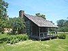 | February 23, 1972 (#72000500) | Ottawa City Park 38°36′39″N 95°16′03″W / 38.610833°N 95.2675°W / 38.610833; -95.2675 (Dietrich Cabin) | Ottawa | In 1857 a German immigrant settled three miles south and two and one-fourth miles west of the present town of Princeton; in 1859, he built this cabin on a hill overlooking the Humboldt trail to replace the original cabin which was destroyed in a prairie fire. |
| 3 | Downtown Ottawa Historic District |  | June 29, 1972 (#72000501) | East side of S. Main St. from No. 135 to 3rd St. 38°36′54″N 95°16′05″W / 38.615°N 95.268056°W / 38.615; -95.268056 (Downtown Ottawa Historic District) | Ottawa | All remaining building are contributing resources for the Historic Ottawa Central Business District. |
| 4 | Eight Mile Creek Warren Truss Bridge | 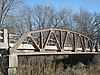 | May 9, 2003 (#03000374) | Osborne Terrace, 0.2 miles west of intersection with Eisenhower Terrace, 1.0 mile west of Main St. 38°37′52″N 95°17′08″W / 38.631111°N 95.285556°W / 38.631111; -95.285556 (Eight Mile Creek Warren Truss Bridge) | Ottawa | |
| 5 | Franklin County Courthouse |  | March 17, 1972 (#72000502) | Main St. 38°36′48″N 95°16′03″W / 38.613333°N 95.2675°W / 38.613333; -95.2675 (Franklin County Courthouse) | Ottawa | |
| 6 | Judge James Hanway House | Upload image | December 11, 2008 (#08001173) | 658 Virginia Rd. 38°25′52″N 95°05′03″W / 38.431111°N 95.084167°W / 38.431111; -95.084167 (Judge James Hanway House) | Lane | |
| 7 | Historic Ottawa Central Business District | | February 7, 2008 (#06000622) | Roughly bounded by Marias des Cygnes River, S. 5th St., Walnut St., and Hickory St. 38°36′54″N 95°16′07″W / 38.615117°N 95.26861°W / 38.615117; -95.26861 (Historic Ottawa Central Business District) | Ottawa | |
| 8 | Tauy Jones Hall |  | June 14, 1982 (#82002659) | Ottawa University campus, 10th and Cedar Sts. 38°36′14″N 95°15′47″W / 38.603889°N 95.263056°W / 38.603889; -95.263056 (Tauy Jones Hall) | Ottawa | |
| 9 | Tauy Jones House | 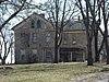 | June 19, 1972 (#72000503) | 3 miles northeast of Ottawa on Tauy Creek 38°39′51″N 95°13′14″W / 38.664167°N 95.220556°W / 38.664167; -95.220556 (Tauy Jones House) | Ottawa | |
| 10 | Middle Creek Tributary Bridge |  | July 2, 1985 (#85001428) | 5.8 miles west of Princeton 38°29′32″N 95°22′33″W / 38.492222°N 95.375833°W / 38.492222; -95.375833 (Middle Creek Tributary Bridge) | Princeton | |
| 11 | Old Santa Fe Railroad Depot | 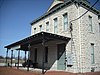 | March 1, 1973 (#73000755) | 135 W. Tecumseh St. 38°37′14″N 95°16′09″W / 38.620556°N 95.269167°W / 38.620556; -95.269167 (Old Santa Fe Railroad Depot) | Ottawa | |
| 12 | Ottawa High School and Junior High School |  | October 6, 2000 (#00001188) | 526 and 506 S. Main St. 38°36′37″N 95°16′07″W / 38.610278°N 95.268611°W / 38.610278; -95.268611 (Ottawa High School and Junior High School) | Ottawa | |
| 13 | Ottawa Library |  | December 1, 1980 (#80001465) | 5th and Main Sts. 38°36′15″N 95°15′43″W / 38.604167°N 95.261944°W / 38.604167; -95.261944 (Ottawa Library) | Ottawa | |
| 14 | Pleasant Valley School District #2 |  | February 26, 2004 (#04000078) | 2905 Thomas Rd. 38°43′27″N 95°08′48″W / 38.724167°N 95.146667°W / 38.724167; -95.146667 (Pleasant Valley School District #2) | Wellsville | |
| 15 | James H. Ransom House | 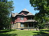 | November 21, 1974 (#74000836) | 318 S. Locust St. 38°36′49″N 95°16′17″W / 38.613611°N 95.271389°W / 38.613611; -95.271389 (James H. Ransom House) | Ottawa | |
| 16 | Lyman Reid House |  | January 11, 2017 (#100000508) | 306 Elm St. 38°36′51″N 95°16′22″W / 38.614071°N 95.272825°W / 38.614071; -95.272825 (Lyman Reid House) | Ottawa | |
| 17 | Silkville |  | December 15, 1972 (#72000504) | 2.5 miles southwest of Williamsburg on U.S. Route 50 38°26′25″N 95°29′13″W / 38.440278°N 95.486944°W / 38.440278; -95.486944 (Silkville) | Williamsburg | |
| 18 | Tauy Creek Bridge |  | October 25, 1990 (#90001567) | Over Tauy Creek, north of Interstate 35 38°39′53″N 95°13′23″W / 38.664722°N 95.223056°W / 38.664722; -95.223056 (Tauy Creek Bridge) | Ottawa | |
| 19 | Walnut Creek Bridge |  | July 2, 1985 (#85001445) | Off K-33, 1 mile south of Wellsville 38°41′18″N 95°05′05″W / 38.688333°N 95.084722°W / 38.688333; -95.084722 (Walnut Creek Bridge) | Wellsville | |
| 20 | Wellsville Bank Building | 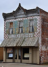 | October 24, 1991 (#91001519) | 418 Main St. 38°43′08″N 95°04′55″W / 38.718889°N 95.081944°W / 38.718889; -95.081944 (Wellsville Bank Building) | Wellsville | The Wellsville Bank was organized on March 4, 1885 by Dr. S. F. Brooking and John Dean. They purchased Lot 9, Block 14 in September, 1884 and commenced construction on Wellsville's first brick building at 418 Main Street. |
See also
Wikimedia Commons has media related to National Register of Historic Places in Franklin County, Kansas.
- List of National Historic Landmarks in Kansas
- National Register of Historic Places listings in Kansas
References
- ^ The latitude and longitude information provided in this table was derived originally from the National Register Information System, which has been found to be fairly accurate for about 99% of listings. Some locations in this table may have been corrected to current GPS standards.
- ^ National Park Service, United States Department of the Interior, "National Register of Historic Places: Weekly List Actions", retrieved September 13, 2024.
- ^ Numbers represent an alphabetical ordering by significant words. Various colorings, defined here, differentiate National Historic Landmarks and historic districts from other NRHP buildings, structures, sites or objects.
- ^ "National Register Information System". National Register of Historic Places. National Park Service. March 13, 2009.
- ^ The eight-digit number below each date is the number assigned to each location in the National Register Information System database, which can be viewed by clicking the number.
- v
- t
- e

- Allen
- Anderson
- Atchison
- Barber
- Barton
- Bourbon
- Brown
- Butler
- Chase
- Chautauqua
- Cherokee
- Cheyenne
- Clark
- Clay
- Cloud
- Coffey
- Comanche
- Cowley
- Crawford
- Decatur
- Dickinson
- Doniphan
- Douglas
- Edwards
- Elk
- Ellis
- Ellsworth
- Finney
- Ford
- Franklin
- Geary
- Gove
- Graham
- Grant
- Gray
- Greeley
- Greenwood
- Hamilton
- Harper
- Harvey
- Haskell
- Hodgeman
- Jackson
- Jefferson
- Jewell
- Johnson
- Kearny
- Kingman
- Kiowa
- Labette
- Lane
- Leavenworth
- Lincoln
- Linn
- Logan
- Lyon
- Marion
- McPherson
- Meade
- Miami
- Mitchell
- Montgomery
- Morris
- Morton
- Nemaha
- Neosho
- Ness
- Norton
- Osage
- Osborne
- Ottawa
- Pawnee
- Phillips
- Pottawatomie
- Pratt
- Rawlins
- Reno
- Republic
- Rice
- Riley
- Rooks
- Rush
- Russell
- Saline
- Scott
- Sedgwick
- Seward
- Shawnee
- Sheridan
- Sherman
- Smith
- Stafford
- Stanton
- Stevens
- Sumner
- Thomas
- Trego
- Wabaunsee
- Wallace
- Washington
- Wichita
- Wilson
- Woodson
- Wyandotte
- Archaeological sites
- National Historic Landmarks
 Category
 NRHP portal


Municipalities and communities of Franklin County, Kansas, United States | ||
|---|---|---|
County seat: Ottawa | ||
| Cities |  | |
| CDP | ||
| Unincorporated communities | ||
| Ghost towns | ||
| Townships | ||
| Footnotes | †This community is designated a Census-Designated Place (CDP) by the United States Census Bureau. | |
| ||


