Moshi Municipal Council, Kilimanjaro
District of Kilimanjaro Region, Tanzania
District in Kilimanjaro Region, Tanzania
Moshi Wilaya ya Moshi (Swahili) | |
|---|---|
District | |
| Wilaya ya Moshi, Mkoa wa Kilimanjaro | |
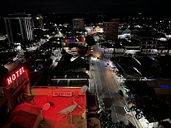 Street scene in Kiusa War, Moshi | |
| Nickname: The Heart of Kilimanjaro | |
 Moshi Municipal in Kilimanjaro Region 2022 | |
| Coordinates: 3°20′34.8″S 37°21′2.52″E / 3.343000°S 37.3507000°E / -3.343000; 37.3507000 | |
| Country | Tanzania |
| Region | Kilimanjaro Region |
| District | 1988 |
| Capital | Moshi |
| Area | |
| • Total | 63.39 km2 (24.48 sq mi) |
| Highest elevation (Karanga) | 896 m (2,940 ft) |
| Population (2022 census)[1] | |
| • Total | 221,733 |
| • Density | 3,500/km2 (9,100/sq mi) |
| Demonym | City Moshian |
| Ethnic groups | |
| • Settler | Swahili |
| • Native | Chaga |
| Tanzanian Postal Code | 25-1 |
| Website | District website |

Moshi Urban District (officially known as Moshi City Council) is an administrative district located in Kilimanjaro Region of Tanzania. The district is home to regional capital of Kilimanjaro Region, namely Moshi. The district covers an area of 63.39 km2 (24.48 sq mi).[2] The district is surrounded on the west by Moshi Rural District, to the east by the Hai District. According to the 2022 Tanzania National Census, the population of Moshi Urban District was 221,733.[3][4]

Administrative subdivisions
Wards
The Moshi Urban District is administratively divided into 21 wards:[5][6]
|
|
|
Education
As of 2022, there were 80 Schools in Moshi Urban District, 52 of are primary schools and 28 are secondary schools.[7]
References
- ^ Citypopulation.de Population of Moshi municipality
- ^ "Tanzania: Northern Tanzania (Districts and Wards) – Population Statistics, Charts and Map".
- ^ "Tanzania: Administrative Division (Regions and Districts) - Population Statistics, Charts and Map". www.citypopulation.de. Retrieved 2024-02-10.
- ^ "Census 2012". National Bureau of Statistics. Archived from the original on 5 March 2016. Retrieved 20 April 2016.
- ^ "Moshi Municipal Council - Background". Archived from the original on 2014-04-08. Retrieved 2014-04-07.
- ^ "Archived copy". Archived from the original on 2014-04-08. Retrieved 2014-04-07.
{{cite web}}: CS1 maint: archived copy as title (link) - ^ "Education Moshi Municipal District Council". Retrieved 2022-06-14.
- v
- t
- e
Capital: Mawenzi
- Bondeni
- Kaloleni
- Karanga
- Kiboriloni
- Kilimanjaro
- Kiusa
- Korongoni
- Longuo
- Majengo
- Mawenzi
- Mji Mpya
- Msaranga
- Njoro
- Rau
- Pasua
- Ng'ambo
- Mfumuni
- Miembeni
- Soweto
- Boma Mbuzi
- Shirimatunda
- Rau River
- Kikafu River
- Karanga River
- Rau Forest Reserve
- Rau Forest Reserve
 | This Kilimanjaro Region location article is a stub. You can help Wikipedia by expanding it. |
- v
- t
- e


