Ma Shi Chau
Tidal island of Hong Kong
22°27′13.94″N 114°13′45.33″E / 22.4538722°N 114.2292583°E / 22.4538722; 114.2292583

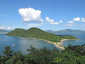
Ma Shi Chau (Chinese: 馬屎洲; Sidney Lau: Ma5Si2Jau1, literally "Horse Dung Island") is an island of Hong Kong, under the administration of Tai Po District. It is located in Tolo Harbour in the northeast New Territories (near Sam Mun Tsai). It is connected with another island, Yim Tin Tsai, by a tombolo traversable at low tide.
It was previously known as No Kot Chai [1] and No Kot Choi [2] (Chinese: 螺角洲).[3]
Geography
Ma Shi Chau has an area of 0.61 km2.[4] It is part of the Ma Shi Chau Special Area, as it exhibits tombolo and tide features rarely seen in Hong Kong. It is the largest island of the four in the Special Area, the others being Yeung Chau, Centre Island and an unnamed island near Yim Tin Tsai.[5][6]
It has sedimentary rock dating back to the Permian period that is protected by its Special Area status.
See also
 Islands portal

- Tidal island
References
- ^ "Hong Kong Historic Maps - Reference 1928 (UK National Archives)". Retrieved 2023-03-23.
- ^ "Hong Kong Historic Maps - Reference 1909 (National Library of Australia)". Retrieved 2023-03-23.
- ^ 黃, 佩佳 (2016). 新界風土名勝大觀. 商务印书馆(香港)有限公司. p. 13. ISBN 9789620756924.
- ^ Geopark Field Guide: Ma Shi Chau
- ^ MA SHI CHAU (SPECIAL AREA) ORDER 1999
- ^ SPECIAL AREAS (DESIGNATION) (CONSOLIDATION) ORDER - CHAPTER 208D
External links
- Ma Shi Chau - Travel Blog
Wikimedia Commons has media related to Ma Shi Chau.
- v
- t
- e
Tai Po District
- A Chau (丫洲, Centre Island)
- Breaker Reef
- Bun Sha Pai (崩紗排)
- Cham Pai (杉排)
- Chau Tsai Kok (洲仔角)
- Che Lei Pai (扯里排)
- Chek Chau (赤洲, Port Island)
- Flat Island (銀洲)
- Hau Tsz Kok Pai (孝子角排)
- Hin Pai (蜆排)
- Kung Chau (弓洲)
- Ma Shi Chau (馬屎洲)
- Ma Yan Pai (媽印排)
- Mo Chau (磨洲)
- Ping Chau (平洲)
- Sam Pui Chau (三杯酒)
- Sha Pai (沙排)
- Shek Ngau Chau (石牛洲)
- Tang Chau (燈洲)
- Tap Mun Chau (塔門洲, Grass Island)
- Tit Shue Pai (鐵樹排)
- Tung Ping Chau
- Wai Chau Pai (灣仔排)
- Wu Chau (烏洲)
- Yeung Chau (洋洲)
- Yim Tin Tsai
- Cloudy Hill
- Hong Kong Railway Museum
- Hong Lok Yuen
- Kadoorie Farm and Botanic Garden
- Lam Tsuen Valley
- Lam Tsuen wishing trees
- Mang Gui Kiu
- Museum of Ethnology
- Plover Cove
- Sai Kung West Country Park
- Tai Po Industrial Estate
- Tai Po Kau Nature Reserve
- Tai Po Lookout
- Tai Po Sports Ground
- Tai Po Waterfront Park
- Three Fathoms Cove
- Historic churches of Sai Kung Peninsula
| MTR stations |
|
|---|
| Primary/secondary | |
|---|---|
| Higher education |
This list is incomplete.
 | This Hong Kong location article is a stub. You can help Wikipedia by expanding it. |
- v
- t
- e


