Liberty State Park station
Light rail station in Jersey City, New Jersey, United States
| Preceding station | Following station | |||
|---|---|---|---|---|
| Garfield Avenue toward West Side Avenue | West Side–Tonnelle | Jersey Avenue toward Tonnelle Avenue | ||
| Richard Street toward 8th Street | 8th Street–Hoboken | Jersey Avenue toward Hoboken | ||
| 45th Street toward 8th Street | Bayonne Flyer | Essex Street toward Hoboken | ||
Location | |
|---|---|
 |
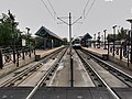
Liberty State Park station is a station on the Hudson–Bergen Light Rail (HBLR) located between Communipaw and Johnston Avenues in Jersey City, New Jersey. The station opened on April 15, 2000.[3] There are two tracks and two side platforms.
Northbound service from the station is available to Hoboken Terminal and Tonnelle Avenue in North Bergen. Southbound service is available to terminals at West Side Avenue in Jersey City or 8th Street in Bayonne. 1248 park and ride spaces are also available one block from the station at the Liberty Science Center. A HBLR yard is located west of the line, south of this station. South of here, the line is in a railroad easement, and speeds are higher than in the parts where it is a streetcar line. New Jersey Transit has been considering a spur from the station to the old Central Railroad of New Jersey Communipaw Terminal within Liberty State Park since at least 2010.[4]
Station layout
Side platform, doors will open on the right  | |
| Southbound | ← West Side–Tonnelle toward West Side Avenue (Garfield Avenue) ← 8th Street–Hoboken toward 8th Street (Richard Street) ← Bayonne Flyer (rush hours) toward 8th Street (45th Street) |
| Northbound | → West Side–Tonnelle toward Tonnelle Avenue (Jersey Avenue) → → 8th Street–Hoboken toward Hoboken (Jersey Avenue) → → Bayonne Flyer (rush hours) toward Hoboken (Essex Street) → |
| Side platform, doors will open on the right | |
Gallery
-
 Hoboken-bound train approaching the station in September 2009
 -
 The station from the pedestrian walkway
 -
 The view from the northern pedestrian crossing


Artwork
-
 Railroad logos etched into glass blocks
 -
 More railroad logos etched into glass blocks
 -
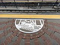 Steam locomotive painted on the concrete of the platform


References
- ^ "Liberty State Park Light Rail Station". NJ Transit. Retrieved July 5, 2023.
- ^ Canal, Alberto (April 16, 2000). "Leaders Cheer Light Rail Opening as Hudson Steps Into 21st Century". The Jersey Journal. Jersey City, New Jersey. pp. A1, A8. Retrieved March 14, 2023 – via Newspapers.com.

- ^ Most, Doug (April 16, 2000). "At Last, A Trolley Runs Through It". The Record. Bergen County. Archived from the original on October 19, 2012. Retrieved March 12, 2022.
- ^ Kaulessar, Ricardo (September 6, 2009). "Trolley through Liberty State Park?". The Hudson Reporter. Bayonne. Archived from the original on March 12, 2022. Retrieved March 12, 2022.
External links
- Station from Google Maps Street View
- Platforms from Google Maps Street View
- v
- t
- e
- 8th Street
- 22nd Street
- 34th Street
- 45th Street
- Danforth Avenue
- Richard Street
- Liberty State Park
- Jersey Avenue
- Marin Boulevard
- Essex Street
- Exchange Place
- Harborside
- Harsimus Cove
- Newport
- Hoboken
| West Side Avenue Branch | |
|---|---|
| Tonnelle Avenue Branch |
- Newark Penn Station
- Military Park
- Washington Street
- Warren Street/NJIT
- Norfolk Street
- Orange Street
- Park Avenue
- Bloomfield Avenue
- Davenport Avenue
- Heller Parkway (closed)
- Branch Brook Park
- Silver Lake
- Grove Street
| Broad Street Line |
|---|
- Trenton
- Hamilton Avenue
- Cass Street
- Bordentown
- Roebling
- Florence
- Burlington Towne Centre
- Burlington South
- Beverly/Edgewater Park
- Delanco
- Riverside
- Cinnaminson
- Riverton
- Palmyra
- Pennsauken–Route 73
- Pennsauken Transit Center
- 36th Street
- Walter Rand Transportation Center
- Cooper Street–Rutgers University
- Aquarium
- Entertainment Center
- Category
- Commons
Italics denote closed stations, stations under construction, and unused line segments.
| Authority control databases |
|
|---|


