Karmrakuch
Place in Khojavend, Azerbaijan
Karmrakuch / Gyrmyzygaya Կարմրակուճ / Qırmızıqaya | |
|---|---|
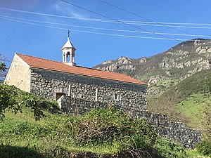 The 19th-century Holy Savior Church in Karmrakuch | |
| 39°32′21″N 47°01′20″E / 39.53917°N 47.02222°E / 39.53917; 47.02222 | |
| Country |  Azerbaijan Azerbaijan |
| District | Khojavend |
| Population (2015)[1] | |
| • Total | 145 |
| Time zone | UTC+4 (AZT) |
Karmrakuch (Armenian: Կարմրակուճ) or Gyrmyzygaya (Azerbaijani: Qırmızıqaya)[2] is a village in the Khojavend District of Azerbaijan, in the disputed region of Nagorno-Karabakh. The village had an ethnic Armenian-majority population prior to the 2020 Nagorno-Karabakh war, and also had an Armenian majority in 1989.[3]
History
During the Soviet period, the village was part of the Hadrut District of the Nagorno-Karabakh Autonomous Oblast. After the First Nagorno-Karabakh War, the village was administrated as part of the Hadrut Province of the breakaway Republic of Artsakh. The village came under the control of Azerbaijan on 14 October 2020, during the 2020 Nagorno-Karabakh war.
Historical heritage sites
Historical heritage sites in and around the village include the fortress of Vnesa (Armenian: Վնեսա), a village and khachkars from between the 10th and 12th centuries, the 19th-century church of Surb Amenaprkich (Armenian: Սուրբ Ամենափրկիչ, lit. 'Holy Savior'), and a 19th-century spring monument and cemetery.[1]
Demographics
The village had 125 inhabitants in 2005,[4] and 145 inhabitants in 2015.[1]
Gallery
-
 Vnesa Fortress from between the 10th and 12th centuries

References
- ^ a b c Hakob Ghahramanyan. "Directory of socio-economic characteristics of NKR administrative-territorial units (2015)".
- ^ "Президент: Азербайджанская Армия освободила еще 8 сел".
- ^ Андрей Зубов. "Андрей Зубов. Карабах: Мир и Война". drugoivzgliad.com.
- ^ "The Results of the 2005 Census of the Nagorno-Karabakh Republic" (PDF). National Statistic Service of the Republic of Artsakh.
External links
- Karmrakuch at GEOnet Names Server
- v
- t
- e
Capital: Khojavend (Martuni)
- Ağbulaq
- Ağbulaq
- Ağcakənd
- Ağdam
- Ağkənd
- Arakül
- Arpadüzü
- Arpagədik
- Ataqut
- Avdur
- Axullu
- Azıx
- Binə
- Binədərəsi
- Böyük Tağlar
- Bulutan
- Bünyadlı
- Cəmiyyət
- Cilən
- Cütcü
- Çağadüz
- Çartar
- Çaylaqqala
- Çinarlı
- Çiraquz
- Çörəkli
- Dağdöşü
- Daşbaşı
- Dərəkənd
- Dolanlar
- Düdükçü
- Edilli
- Edişə
- Əmiranlar
- Gavahın
- Günəşli
- Güneyxırman
- Hadrut
- Heşan
- Hünərli
- Kəndxurd
- Kiş
- Köhnə Tağlar
- Kuropatkino
- Məlikcanlı
- Məmməddərə
- Mirikənd
- Muğanlı
- Mülküdərə
- Müşkapat
- Petrosashen
- Qağartsi
- Qaradağlı
- Qarakənd
- Qarazəmi
- Qarıtəpə
- Qarqar
- Qırmızı Bazar
- Qırmızıqaya
- Qoçbəyli
- Quşçular
- Quzeyxırman
- Quzumkənd
- Salakətin
- Sor
- Sos
- Spitakşen
- Susanlıq
- Şahyeri
- Şexer
- Şıx Dursun
- Tağaser
- Tağaverd
- Tuğ
- Xanoba
- Xərxan
- Xırmancıq
- Yemişcan
- Yenikənd
- Zavadıx
- Zərdanaşen
- Zoğalbulaq

| ||
|---|---|---|
Capital: Hadrut | ||
| Urban comunities |  | |
| Rural comunities |
| |
Portal:
 Geography

 | This Khojavend District location article is a stub. You can help Wikipedia by expanding it. |
- v
- t
- e


