Satellite photo of the northern part of the island of São Tomé with Ilhéu das Cabras
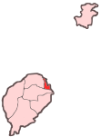
Ilhéu das Cabras is an uninhabited island in the Gulf of Guinea. It is one of the smaller islands of São Tomé and Príncipe. The islet is located about 2 km off the northeast coast of the island of São Tomé, 8 km north of the city centre of São Tomé. The islet consists of two hills, about 90 metres high.[1] There is a lighthouse on the northeastern summit,[1] built in 1890; its focal height 97 metres[2] and its range is 12 nmi (22 km; 14 mi).[3] The islet was mentioned as "Mooro Caebres" in the 1665 map by Johannes Vingboons.[4]
References
^ abSailing Directions (Enroute), Pub. 123: Southwest Coast of Africa(PDF). Sailing Directions. United States National Geospatial-Intelligence Agency. 2017. p. 76.
^List of Lights, Pub. 113: The West Coasts of Europe and Africa, the Mediterranean Sea, Black Sea and Azovskoye More (Sea of Azov)(PDF). List of Lights. United States National Geospatial-Intelligence Agency. 2018. p. 442.
^1665 map of the island of St Thomé by Johannes Vingboons[permanent dead link], now at the Dutch National Archive
External links
Media related to Ilhéu das Cabras at Wikimedia Commons


 Media related to Ilhéu das Cabras at Wikimedia Commons