Hevenor Inlet
Fjord in Pitt Island, British Columbia
53°38′28″N 129°59′17″W / 53.64111°N 129.98806°W / 53.64111; -129.98806Hevenor Inlet extends eastward from Petrel Channel on the northwest side of Pitt Island, British Columbia, Canada.[2]
The inlet is entered between Stark Point[3] and Hevenor Point,[4] and contains Clark[5] and Hevenor[6] islets. A narrow entrance connects the inlet to Hevenor Lagoon[7] 4 nautical miles (7.4 km; 4.6 mi) southeast of the head of the inlet.[8]
Two Indian Reserves adjoin the inlet, Pitt Island 27[9] on the north shore near the entrance, and Ketai 28[10] midway down the south shore.
Hevenor Inlet is surrounded by waterfalls, including the Cascades, a linear series of waterfalls at the head of the inlet.
Image Gallery
Wikimedia Commons has media related to Hevenor Inlet.
-
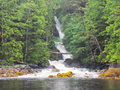 The mouth of the Cascades at the head of Hevenor Inlet
 -
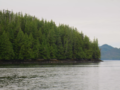
 Fog lifting around Clark Islet
 -
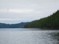
 The narrows between the Inlet and the Lagoon
 -
 Looking at Hevenor Islet from the southwest
 -
 Stark Point, south of the mouth of Hevenor Inlet
 -
 Hevenor Point, north of the mouth of Hevenor Inlet


References
- ^ Susan Marsden (2011). The Gitkxaala, Their History, and Their Territories (Porcher Island, Banks Island, Pitt Island and Adjacent Islands) (PDF) (Report). p. 55.
- ^ "Hevenor Inlet". BC Geographical Names.
- ^ "Stark Point". BC Geographical Names.
- ^ "Hevenor Point". BC Geographical Names.
- ^ "Clark Islet". BC Geographical Names.
- ^ "Hevenor Inlet". BC Geographical Names.
- ^ "Hevenor Lagoon". BC Geographical Names.
- ^ "Chart 3746, Petrel Channel". Sailing Directions, British Columbia Coast, (Northern Portion). II (Ninth Edition): 259. 1983.
- ^ "Pitt Island 27". BC Geographical Names.
- ^ "Ketai 28". BC Geographical Names.
- v
- t
- e


