Harsin
City in Kermanshah province, Iran
City in Kermanshah, Iran
Harsin Persian: هرسين | |
|---|---|
City | |
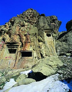 Eshaqvand rock tombs | |
| 34°16′22″N 47°35′15″E / 34.27278°N 47.58750°E / 34.27278; 47.58750[1] | |
| Country | Iran |
| Province | Kermanshah |
| County | Harsin |
| District | Central |
| Established | 550 BC |
| Population (2016)[2] | |
| • Total | 44,146 |
| Time zone | UTC+3:30 (IRST) |
Harsin (Persian: هرسين)[a] is a city in the Central District of Harsin County, Kermanshah province, Iran, serving as capital of both the county and the district.[4] Harsin was founded in 550 BC.[citation needed]
Demographics
Language and ethnicity
The city is populated by different Kurdish tribes including the Osmanvand and the Jalalvand who speak Laki.[5]
Population
At the time of the 2006 National Census, the city's population was 51,562 in 12,001 households.[6] The following census in 2011 counted 49,967 people in 13,700 households.[7] The 2016 census measured the population of the city as 44,146 people in 12,814 households.[2]
See also
 Iran portal
Notes
- ^ Also romanized as Harsīn (Kurdish: هەرسين)[3]
References
- ^ OpenStreetMap contributors (5 March 2024). "Harsin, Harsin County" (Map). OpenStreetMap (in Persian). Retrieved 5 March 2024.
- ^ a b "Census of the Islamic Republic of Iran, 1395 (2016)". AMAR (in Persian). The Statistical Center of Iran. p. 05. Archived from the original (Excel) on 3 April 2022. Retrieved 19 December 2022.
- ^ Harsin can be found at GEOnet Names Server, at this link, by opening the Advanced Search box, entering "-3065919" in the "Unique Feature Id" form, and clicking on "Search Database".
- ^ Habibi, Hassan. "Divisional reforms in Kermanshah province". Lamtakam (in Persian). Ministry of Interior, Political and Defense Commission of the Government Board. Archived from the original on 30 January 2024. Retrieved 30 January 2024.
- ^ Fattah, Ismaïl Kamandâr (2000). Les dialectes kurdes méridionaux. Acta Iranica 37. p. 22.
- ^ "Census of the Islamic Republic of Iran, 1385 (2006)". AMAR (in Persian). The Statistical Center of Iran. p. 05. Archived from the original (Excel) on 20 September 2011. Retrieved 25 September 2022.
- ^ "Census of the Islamic Republic of Iran, 1390 (2011)". Syracuse University (in Persian). The Statistical Center of Iran. p. 05. Archived from the original (Excel) on 18 January 2023. Retrieved 19 December 2022.
External links
- Iran Travel Guide: Harsin Archived 18 February 2013 at archive.today
- v
- t
- e
Kermanshah Province, Iran

- Kohneh Bridge
- Behistun Inscription
- Taq-e Bostan
- Temple of Anahita
- The Stone cave Hossein Kuhkan
- Dinavar
- Ganj Dareh
- Essaqwand Rock Tombs
- Sorkh Deh chamber tomb
- Malek Tomb
- Hulwan
- Median dakhmeh(Darbad,Sahneh)
- Ghar Parau
- Do-Ashkaft Cave
- Tekyeh Moaven al-molk
- Dokan Davood Inscription,Sar Pol-e-Zahab
- Tagh e gara,Patagh pass
- Sarab Niloufar
- Ghoori Ghale Cave
- Khaja Barookh's House
- Chiyajani Tappe
- Statue of Herakles in Behistun complex
- Emad al doleh Mosque
- Tekyeh Biglarbeygi
- Hunters cave,Behistun_complex
- Jamé Mosque of Kermanshah
- Godin Tepe
- Bas relief of Gotarzes II of Parthia
- Anubanini rock relief

 | This Harsin County location article is a stub. You can help Wikipedia by expanding it. |
- v
- t
- e


 Harsin