Grade II* listed buildings in Erewash
Map all coordinates using OpenStreetMap
Download coordinates as:
- KML
- GPX (all coordinates)
- GPX (primary coordinates)
- GPX (secondary coordinates)
There are over 20,000 Grade II* listed buildings in England. This page is a list of these buildings in the district of Erewash in Derbyshire.
List of buildings
| Name | Location | Type | Completed [note 1] | Date designated | Grid ref.[note 2] Geo-coordinates | Entry number [note 3] | Image |
|---|---|---|---|---|---|---|---|
| The Old Hall | Breadsall | House | 16th century | 10 November 1967 | SK3707539828 52°57′16″N 1°26′59″W / 52.954553°N 1.449592°W / 52.954553; -1.449592 (The Old Hall) | 1141230 | 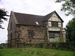 More images |
| Locko Park | Dale Abbey | Country house | 1669 | 2 September 1952 | SK4096738648 52°56′37″N 1°23′31″W / 52.943664°N 1.391813°W / 52.943664; -1.391813 (Locko Park) | 1140431 |  More images |
| Mausoleum west of Saint Matthews Church | Morley | Mausoleum | 1897 | 6 November 1986 | SK3962940938 52°57′52″N 1°24′41″W / 52.964349°N 1.411443°W / 52.964349; -1.411443 (Mausoleum west of Saint Matthews Church) | 1205888 |  More images |
| The Recreation Room, Tithe Barn and Dovecote | Morley | House | 16th century | 2 September 1952 | SK3967540956 52°57′52″N 1°24′39″W / 52.964507°N 1.410756°W / 52.964507; -1.410756 (The Recreation Room, Tithe Barn and Dovecote) | 1140415 | 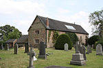 |
| Church of All Saints | Ockbrook | Church | Late 12th century | 10 November 1967 | SK4237035702 52°55′01″N 1°22′17″W / 52.917075°N 1.371319°W / 52.917075; -1.371319 (Church of All Saints) | 1087941 | 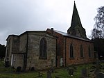 More images |
| The Moravian Chapel/church | Ockbrook | Church | 1751 | 10 November 1967 | SK4213836176 52°55′17″N 1°22′29″W / 52.921354°N 1.374708°W / 52.921354; -1.374708 (The Moravian Chapel/church) | 1204382 |  More images |
| The Moravian Manse | Ockbrook | House | c.1800 | 10 November 1967 | SK4212636169 52°55′17″N 1°22′30″W / 52.921292°N 1.374888°W / 52.921292; -1.374888 (The Moravian Manse) | 1204379 |  Upload Photo |
| Balustrades, gateway and bridge on terrace to south east of Risley Hall | Risley | Balustrade | Early 17th century | 10 November 1967 | SK4607735536 52°54′55″N 1°18′58″W / 52.915278°N 1.316217°W / 52.915278; -1.316217 (Balustrades, gateway and bridge on terrace to south east of Risley Hall) | 1087914 |  More images |
| Church of All Saints | Risley | Church | 1593 | 10 November 1967 | SK4610535701 52°55′00″N 1°18′57″W / 52.916759°N 1.315777°W / 52.916759; -1.315777 (Church of All Saints) | 1334829 | 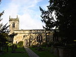 More images |
| Latin College and the Latin Cottage | Risley | House | 1720 | 2 September 1952 | SK4616135692 52°55′00″N 1°18′54″W / 52.916673°N 1.314945°W / 52.916673; -1.314945 (Latin College and the Latin Cottage) | 1087956 |  More images |
| Latin House | Risley | House | 1706 | 2 September 1952 | SK4612935679 52°55′00″N 1°18′56″W / 52.916559°N 1.315423°W / 52.916559; -1.315423 (Latin House) | 1087955 |  More images |
| The Old School House | Risley | House | c.1720 | 2 September 1952 | SK4616835714 52°55′01″N 1°18′53″W / 52.916871°N 1.314838°W / 52.916871; -1.314838 (The Old School House) | 1204445 |  More images |
| Church of St Michael and All Angels | Stanton by Dale | Church | Early 14th century | 10 November 1967 | SK4648238143 52°56′19″N 1°18′35″W / 52.938677°N 1.309822°W / 52.938677; -1.309822 (Church of St Michael and All Angels) | 1206037 |  More images |
| Church of St Wilfrid | West Hallam | Church | 15th century | 10 November 1967 | SK4321841116 52°57′56″N 1°21′29″W / 52.965672°N 1.357989°W / 52.965672; -1.357989 (Church of St Wilfrid) | 1140423 | 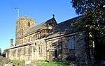 More images |
| Bennerley Viaduct | Ilkeston | Railway viaduct | 1878–79 | 21 November 1974 | SK4722143809 52°59′22″N 1°17′53″W / 52.989542°N 1.298002°W / 52.989542; -1.298002 (Bennerley Viaduct) | 1140437 | 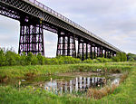 More images |
| Church of St Laurence and St James | Long Eaton | Church | 12th century | 22 October 1962 | SK4915833736 52°53′56″N 1°16′14″W / 52.898827°N 1.270673°W / 52.898827; -1.270673 (Church of St Laurence and St James) | 1204249 |  More images |
| Church of St Mary | Ilkeston | Church | Early 13th century | 26 September 1963 | SK4654941739 52°58′16″N 1°18′30″W / 52.970994°N 1.30831°W / 52.970994; -1.30831 (Church of St Mary) | 1205669 |  More images |
| Ormiston Ilkeston Enterprise Academy | Ilkeston | School | 1910–14 | 6 November 1986 | SK4604441827 52°58′19″N 1°18′57″W / 52.971829°N 1.315816°W / 52.971829; -1.315816 (Ormiston Ilkeston Enterprise Academy) | 1329206 |  More images |
| Scala Cinema | Ilkeston | Cinema | 1913 | 6 November 1986 | SK4643941782 52°58′17″N 1°18′36″W / 52.97139°N 1.309941°W / 52.97139; -1.309941 (Scala Cinema) | 1205711 |  More images |
| The Hall | Long Eaton | House | 1778 | 22 October 1962 | SK4905233917 52°54′02″N 1°16′20″W / 52.900463°N 1.272222°W / 52.900463; -1.272222 (The Hall) | 1204191 |  More images |
See also
- Grade I listed buildings in Derbyshire
- Grade II* listed buildings in Amber Valley
- Grade II* listed buildings in Bolsover (district)
- Grade II* listed buildings in Chesterfield
- Grade II* listed buildings in Derby
- Grade II* listed buildings in Derbyshire Dales
- Grade II* listed buildings in High Peak
- Grade II* listed buildings in North East Derbyshire
- Grade II* listed buildings in South Derbyshire
Notes
- ^ The date given is the date used by Historic England as significant for the initial building or that of an important part in the structure's description.
- ^ Sometimes known as OSGB36, the grid reference is based on the British national grid reference system used by the Ordnance Survey.
- ^ The "List Entry Number" is a unique number assigned to each listed building and scheduled monument by Historic England.
External links
- v
- t
- e
- Bedfordshire
- Berkshire
- Bristol
- Buckinghamshire
- Cambridgeshire
- Cheshire
- Cornwall
- Cumbria
- Derbyshire
- Devon
- Dorset
- Durham
- East Sussex
- East Riding of Yorkshire
- Essex
- Gloucestershire
- Greater London
- Greater Manchester
- Hampshire
- Herefordshire
- Hertfordshire
- Isle of Wight
- Kent
- Lancashire
- Leicestershire
- Lincolnshire
- Merseyside
- Norfolk
- North Yorkshire
- Northamptonshire
- Northumberland
- Nottinghamshire
- Oxfordshire
- Rutland
- Shropshire
- Somerset
- South Yorkshire
- Staffordshire
- Suffolk
- Surrey
- Tyne and Wear
- Warwickshire
- West Midlands
- West Sussex
- West Yorkshire
- Wiltshire
- Worcestershire
- Allerdale
- Amber Valley
- Ashford
- Babergh
- Barrow-in-Furness
- Basildon
- Basingstoke and Deane
- Bath and North East Somerset
- Bolsover
- Boston
- Bournemouth
- Bradford
- Braintree
- Breckland
- Brentwood
- Brighton and Hove
- Bristol
- Broadland
- Calderdale
- Cambridge
- Camden
- Canterbury
- Carlisle
- Castle Point
- Chelmsford
- Cheltenham
- Cherwell
- Cheshire East
- Cheshire West and Chester
- Chesterfield
- Chiltern
- Christchurch
- Colchester
- Copeland
- Corby
- Cotswold
- Dartford
- Daventry
- Dover
- East Cambridgeshire
- Exeter
- Mendip
- North Somerset
- North Yorkshire (district)
- Poole
- Sedgemoor
- South Somerset
- Stoke-on-Trent
- Taunton Deane
- West Somerset
- York


