Dhampus
Village Development Committee in Gandaki Zone, Nepal
Dhampus धम्पुस | |
|---|---|
Village Development Committee | |
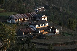 Early morning in Dhampus | |
28°19′N 83°51′E / 28.31°N 83.85°E / 28.31; 83.85 | |
| Country |  Nepal Nepal |
| Zone | Gandaki Zone |
| District | Kaski District |
| Population (1991) | |
| • Total | 2,753 |
| Time zone | UTC+5:45 (Nepal Time) |
Dhampus is a village and Village Development Committee in Kaski District in the Gandaki Zone of northern-central Nepal. The village is located 19 km away from the Pokhara Baglung Highways and falls within the trekking route of Mardi Himal Trek.[1] At the 1991 Nepal census, it had a population of 2,753 persons in 547 individual households. The village is gradually turning into a tourist destination. It has the Australian Base Camp with views of the peaks Annapurna, Dhaulagiri and Machhapuchhre.[2]
Gallery
- Dhampus
-
 Annapurna-Hiunchuli-Machhapuchhre
 -
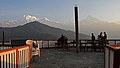
 Breakfast view of Annapurna and Hiunchuli
 -
 Hotel pavillon
 -
 Hotel kitchen
 -
 Hotel room
 -
 Morning light catcher
 -
 Farm house
 -
 Fields around Dhampus


References
External links
- UN map of the municipalities of Kaski District
- v
- t
- e
Kaski District
Headquarters: Pokhara
- Pokhara
- Arba Vijaya
- Armala
- Begnas
- Bhachok
- Bhadaure Tamagi
- Bhalam
- Bharat Pokhari
- Chapakot
- Dangsing
- Deurali
- Dhampus
- Dhikur Pokhari
- Dhital
- Ghachok
- Ghandruk
- Hansapur
- Hemja
- Kahun
- Kalika
- Kaskikot
- Kristinachnechaur
- Lahachok
- Lamachaur
- Lekhnath Municipality
- Lumle
- Lwangghale
- Machhapuchchhre
- Majhthana
- Mala
- Mauja
- Mijuredanda
- Namarjung
- Nirmalpokhari
- Parche
- Pumdibhumdi
- Puranchaur
- Rakhi
- Ribhan
- Rupakot
- Saimarang
- Salyan
- Sarangkot
- Sardikhola
- Shisuwa
- Siddha
- Sildujure
- Thumakodada
- Thumki
 | This article about a location in the Kaski District of Nepal is a stub. You can help Wikipedia by expanding it. |
- v
- t
- e


