Commonwealth Heritage List in Queensland
List of Queensland Commonwealth Heritage locations
Map all coordinates using OpenStreetMap
Download coordinates as:
- KML
- GPX (all coordinates)
- GPX (primary coordinates)
- GPX (secondary coordinates)
This is a list of places on the Commonwealth Heritage List in Queensland. The Commonwealth Heritage List is a heritage register which lists places of historic, cultural and natural heritage on Commonwealth land or in Commonwealth waters, or owned or managed by the Commonwealth Government. To be listed, a place has to meet one or more of the nine Commonwealth Heritage List criteria.[1]
Currently listed places
As of 30 April 2020[update], there are 31 places in Queensland listed on the Commonwealth Heritage List :[2]
| Place name | Class | Listed | Address | Suburb or town | Coordinates | Photo |
|---|---|---|---|---|---|---|
| ABC Radio Studios [3] | Historic | 14 September 2009 | 236 Quay Street | Rockhampton | 23°22′48″S 150°30′57″E / 23.3801°S 150.5157°E / -23.3801; 150.5157 (ABC Radio Studios, Rockhampton) |  |
| Ayr Post Office [4] | Historic | 22 August 2012 | 155 Queen Street | Ayr | 19°34′34″S 147°24′17″E / 19.5762°S 147.4047°E / -19.5762; 147.4047 (Ayr Post Office) |  |
| Boonah Post Office [5] | Historic | 8 November 2011 | 1 Park Street | Boonah | 27°59′51″S 152°40′55″E / 27.9975°S 152.6819°E / -27.9975; 152.6819 (Boonah Post Office) |  |
| Bowen Post Office [6] | Historic | 8 November 2011 | 46 Herbert Street | Bowen | 20°00′44″S 148°14′48″E / 20.0122°S 148.2468°E / -20.0122; 148.2468 (Bowen Post Office) |  |
| Bundaberg Post Office [7] | Historic | 8 November 2011 | 155a Bourbong Street | Bundaberg | 24°51′57″S 152°20′54″E / 24.8659°S 152.3484°E / -24.8659; 152.3484 (Bundaberg Post Office) | 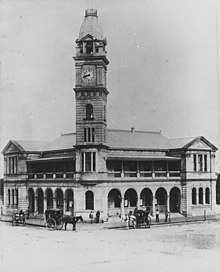 |
| Charters Towers Post Office [8] | Historic | 8 November 2011 | 17 Gill Street | Charters Towers | 20°04′33″S 146°15′29″E / 20.0758°S 146.2580°E / -20.0758; 146.2580 (Charters Towers Post Office) | 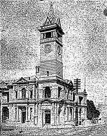 |
| Cooroy Post Office [9] | Historic | 22 August 2012 | 33 Maple Street | Cooroy | 26°25′06″S 152°54′37″E / 26.4184°S 152.9104°E / -26.4184; 152.9104 (Cooroy Post Office) | 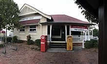 |
| Dent Island Light [10] | Historic | 22 June 2004 | Dent Island | Whitsundays | 20°22′09″S 148°55′44″E / 20.3693°S 148.9290°E / -20.3693; 148.9290 (Dent Island Light) |  |
| Enoggera Magazine Complex [11] | Historic | 22 June 2004 | Gallipoli Barracks, Inwood Road | Enoggera | 27°26′03″S 152°58′40″E / 27.4341°S 152.9779°E / -27.4341; 152.9779 (Enoggera Magazine Complex) | |
| General Post Office, Brisbane [12] | Historic | 22 June 2004 | 261-285 Queen Street | Brisbane City | 27°28′05″S 153°01′42″E / 27.4681°S 153.0282°E / -27.4681; 153.0282 (General Post Office, Brisbane) |  |
| Goods Island Light [13] | Historic | 22 June 2004 | Goods Island | Torres Strait | 10°33′54″S 142°09′08″E / 10.5651°S 142.1523°E / -10.5651; 142.1523 (Goods Island Light) |  |
| Green Hill Fort [14] | Historic | 28 May 2008 | Chester Street | Thursday Island | 10°35′02″S 142°12′40″E / 10.5840°S 142.2110°E / -10.5840; 142.2110 (Green Hill Fort) | |
| Greenbank Military Range [15] | Natural | 22 June 2004 | Middle Road | Greenbank | 27°40′15″S 152°57′57″E / 27.6707°S 152.9659°E / -27.6707; 152.9659 (Greenbank Military Range) | |
| Ingham Post Office [16] | Historic | 22 August 2012 | 15 Lannercost Street | Ingham | 18°39′03″S 146°09′18″E / 18.6509°S 146.1551°E / -18.6509; 146.1551 (Ingham Post Office) |  |
| Lady Elliot Island Light [17] | Historic | 22 June 2004 | Lady Elliot Island | Coral Sea | 24°06′53″S 152°42′43″E / 24.1148°S 152.7119°E / -24.1148; 152.7119 (Lady Elliot Island Light) |  |
| Land Warfare Centre [18] | Natural | 22 June 2004 | Tamborine Mountain Road | Canungra | 28°01′45″S 153°12′41″E / 28.0291°S 153.2114°E / -28.0291; 153.2114 (Land Warfare Centre (Australia)) | |
| Low Isles Light [19] | Historic | 28 May 2008 | Low Island | Low Isles | 16°23′03″S 145°33′36″E / 16.3842°S 145.5599°E / -16.3842; 145.5599 (Low Island (Queensland)) |  |
| Macrossan Stores Depot Group [20] | Historic | 22 June 2004 | Flinders Highway | Macrossan | 20°00′30″S 146°29′18″E / 20.0083°S 146.4882°E / -20.0083; 146.4882 (Macrossan Stores Depot Group) | |
| Maryborough Post Office [21] | Historic | 8 November 2011 | 227 Bazaar Street | Maryborough | 25°32′15″S 152°42′16″E / 25.5375°S 152.7045°E / -25.5375; 152.7045 (Maryborough Post Office) | 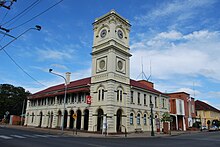 |
| Naval Offices [22] | Historic | 22 June 2004 | 3 Edward Street | Brisbane City | 27°28′19″S 153°01′51″E / 27.4719°S 153.0307°E / -27.4719; 153.0307 (Naval Offices, Brisbane) |  |
| North Reef Light [23] | Historic | 22 June 2004 | North Reef Island, off Rockhampton | Coral Sea | 23°11′06″S 151°54′11″E / 23.1851°S 151.9031°E / -23.1851; 151.9031 (North Reef Light) |  |
| RAAF Base Amberley heritage structures [24] | Historic | 22 June 2004 | Southern Amberley Road | Amberley | 27°38′22″S 152°42′26″E / 27.6394°S 152.7072°E / -27.6394; 152.7072 (RAAF Base Amberley heritage structures) | |
| Remount Complex [25] | Historic | 22 June 2004 | Wynter Road | Enoggera | 27°25′47″S 152°58′59″E / 27.4296°S 152.9831°E / -27.4296; 152.9831 (Remount Complex) | |
| School of Musketry [26] | Historic | 22 June 2004 | Gallipoli Barracks, 431 Lloyd Street | Enoggera | 27°25′28″S 152°59′09″E / 27.4244°S 152.9859°E / -27.4244; 152.9859 (School Of Musketry, Enoggera) | |
| Shoalwater Bay Military Training Area [27] | Natural | 22 June 2004 | Byfield Road | Byfield | 22°32′52″S 150°29′14″E / 22.5479°S 150.4873°E / -22.5479; 150.4873 (Shoalwater Bay Military Training Area) | |
| Small Arms Magazine [28] | Historic | 22 June 2004 | Gallipoli Barracks, Murray Avenue | Enoggera | 27°25′29″S 152°59′05″E / 27.4247°S 152.9848°E / -27.4247; 152.9848 (Small Arms Magazine, Enoggera) | |
| Stanthorpe Post Office [29] | Historic | 22 June 2004 | 14 Maryland Street | Stanthorpe | 28°39′20″S 151°56′01″E / 28.6556°S 151.9337°E / -28.6556; 151.9337 (Stanthorpe Post Office) |  |
| Tully Training Area [30] | Natural | 22 June 2004 | Tully-Cardstone Road | Tully | 17°50′29″S 145°48′19″E / 17.8413°S 145.8053°E / -17.8413; 145.8053 (Tully Training Area) | |
| Victoria Barracks [31] | Historic | 14 September 2009 | 83 - 129 Petrie Terrace | Petrie Terrace | 27°27′53″S 153°00′53″E / 27.4647°S 153.0147°E / -27.4647; 153.0147 (Victoria Barracks) |  |
| Warwick Post Office [32] | Historic | 8 November 2011 | 98 Palmerin Street | Warwick | 28°12′59″S 152°01′59″E / 28.2165°S 152.0330°E / -28.2165; 152.0330 (Warwick Post Office) | 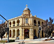 |
| Wide Bay Military Reserve [33] | Natural | 22 June 2004 | Tin Can Bay Road | Tin Can Bay | 25°52′24″S 152°56′05″E / 25.8733°S 152.9348°E / -25.8733; 152.9348 (Wide Bay Military Reserve) |
Formerly listed places
As of 30 April 2020[update], there is one place in Queensland formerly on the Commonwealth Heritage List:[34]
| Place name | Class | Address | Suburb or town | Coordinates | Photo |
|---|---|---|---|---|---|
| Kissing Point Fortification [35] | Historic | 44 Howitt Street | North Ward | 19°14′24″S 146°48′15″E / 19.2399°S 146.8043°E / -19.2399; 146.8043 (Kissing Point Fort) |  |
See also
References
- ^ "Commonwealth Heritage List criteria". environment.gov.au. Department of Agriculture, Water and the Environment. Retrieved 29 April 2020.
- ^ "Search Results for Queensland". Department of Agriculture, Water and the Environment. Australian Government. Retrieved 30 April 2020.
- ^ "ABC Radio Studios (Place ID 105420)". Australian Heritage Database. Australian Government. Retrieved 30 April 2020.
- ^ "Ayr Post Office (Place ID 106172)". Australian Heritage Database. Australian Government. Retrieved 30 April 2020.
- ^ "Boonah Post Office (Place ID 106123)". Australian Heritage Database. Australian Government. Retrieved 30 April 2020.
- ^ "Bowen Post Office (Place ID 106124)". Australian Heritage Database. Australian Government. Retrieved 30 April 2020.
- ^ "Bundaberg Post Office (Place ID 106125)". Australian Heritage Database. Australian Government. Retrieved 30 April 2020.
- ^ "Charters Towers Post Office (Place ID 105523)". Australian Heritage Database. Australian Government. Retrieved 30 April 2020.
- ^ "Cooroy Post Office (Place ID 106202)". Australian Heritage Database. Australian Government. Retrieved 30 April 2020.
- ^ "Dent Island Lightstation (Place ID 105369)". Australian Heritage Database. Australian Government. Retrieved 30 April 2020.
- ^ "Enoggera Magazine Complex (Place ID 105229)". Australian Heritage Database. Australian Government. Retrieved 30 April 2020.
- ^ "Brisbane General Post Office (Place ID 105521)". Australian Heritage Database. Australian Government. Retrieved 30 April 2020.
- ^ "Goods Island Lighthouse (Place ID 105458)". Australian Heritage Database. Australian Government. Retrieved 30 April 2020.
- ^ "Green Hill Fort (Place ID 105419)". Australian Heritage Database. Australian Government. Retrieved 30 April 2020.
- ^ "Greenbank Military Training Area (Place ID 105235)". Australian Heritage Database. Australian Government. Retrieved 30 April 2020.
- ^ "Ingham Post Office (Place ID 106200)". Australian Heritage Database. Australian Government. Retrieved 30 April 2020.
- ^ "Lady Elliot Island Lightstation (Place ID 105415)". Australian Heritage Database. Australian Government. Retrieved 30 April 2020.
- ^ "Canungra Land Warfare Centre Training Area (Place ID 105479)". Australian Heritage Database. Australian Government. Retrieved 30 April 2020.
- ^ "Low Island and Low Islets Lightstation (Place ID 105367)". Australian Heritage Database. Australian Government. Retrieved 30 April 2020.
- ^ "Macrossan Stores Depot Group (Place ID 105330)". Australian Heritage Database. Australian Government. Retrieved 30 April 2020.
- ^ "Maryborough Post Office (Place ID 106140)". Australian Heritage Database. Australian Government. Retrieved 30 April 2020.
- ^ "Naval Offices (Place ID 105225)". Australian Heritage Database. Australian Government. Retrieved 30 April 2020.
- ^ "North Reef Lightstation (Place ID 105368)". Australian Heritage Database. Australian Government. Retrieved 30 April 2020.
- ^ "Amberley RAAF Base Group (Place ID 105650)". Australian Heritage Database. Australian Government. Retrieved 30 April 2020.
- ^ "Remount Complex (former) (Place ID 105638)". Australian Heritage Database. Australian Government. Retrieved 30 April 2020.
- ^ "School Of Musketry (former) (Place ID 105227)". Australian Heritage Database. Australian Government. Retrieved 30 April 2020.
- ^ "Shoalwater Bay Military Training Area (Place ID 105545)". Australian Heritage Database. Australian Government. Retrieved 30 April 2020.
- ^ "Small Arms Magazine (former) (Place ID 105228)". Australian Heritage Database. Australian Government. Retrieved 30 April 2020.
- ^ "Stanthorpe Post Office (Place ID 105524)". Australian Heritage Database. Australian Government. Retrieved 30 April 2020.
- ^ "Tully Training Area (Place ID 105654)". Australian Heritage Database. Australian Government. Retrieved 30 April 2020.
- ^ "Victoria Barracks (Place ID 105226)". Australian Heritage Database. Australian Government. Retrieved 30 April 2020.
- ^ "Warwick Post Office (Place ID 105537)". Australian Heritage Database. Australian Government. Retrieved 30 April 2020.
- ^ "Wide Bay Military Reserve (Place ID 105285)". Australian Heritage Database. Australian Government. Retrieved 30 April 2020.
- ^ "Search Results for Queensland". Department of Agriculture, Water and the Environment. Australian Government. Retrieved 30 April 2020.
- ^ "Kissing Point Fort (Place ID 105329)". Australian Heritage Database. Australian Government. Retrieved 1 May 2020.


