Colombia, Huila
Municipality and town in Huila Department, Colombia

Flag

Seal
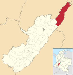
Location of the municipality and town of Colombia, Huila in the Huila Department of Colombia.
 Colombia
[1]
(Census 2018[2])
Colombia is a town and municipality in the Huila Department, Colombia.
Climate
| Climate data for Colombia (Sta Ana), elevation 1,410 m (4,630 ft), (1981–2010) | |||||||||||||
|---|---|---|---|---|---|---|---|---|---|---|---|---|---|
| Month | Jan | Feb | Mar | Apr | May | Jun | Jul | Aug | Sep | Oct | Nov | Dec | Year |
| Mean daily maximum °C (°F) | 26.0 (78.8) | 26.0 (78.8) | 25.4 (77.7) | 24.9 (76.8) | 24.4 (75.9) | 24.3 (75.7) | 24.4 (75.9) | 25.3 (77.5) | 25.9 (78.6) | 25.6 (78.1) | 24.7 (76.5) | 25.1 (77.2) | 25.2 (77.4) |
| Daily mean °C (°F) | 20.1 (68.2) | 20.3 (68.5) | 20.1 (68.2) | 19.9 (67.8) | 19.8 (67.6) | 19.3 (66.7) | 19.2 (66.6) | 19.7 (67.5) | 20.0 (68.0) | 20.0 (68.0) | 19.8 (67.6) | 19.9 (67.8) | 19.8 (67.6) |
| Mean daily minimum °C (°F) | 15.7 (60.3) | 16.0 (60.8) | 16.4 (61.5) | 16.5 (61.7) | 16.3 (61.3) | 15.5 (59.9) | 15.1 (59.2) | 15.2 (59.4) | 15.7 (60.3) | 15.9 (60.6) | 16.3 (61.3) | 15.9 (60.6) | 15.9 (60.6) |
| Average precipitation mm (inches) | 63.9 (2.52) | 62.9 (2.48) | 113.5 (4.47) | 111.7 (4.40) | 107.3 (4.22) | 60.9 (2.40) | 60.9 (2.40) | 36.7 (1.44) | 54.7 (2.15) | 133.6 (5.26) | 155.7 (6.13) | 83.7 (3.30) | 1,034 (40.7) |
| Average precipitation days | 10 | 10 | 16 | 18 | 19 | 17 | 16 | 11 | 14 | 19 | 20 | 14 | 182 |
| Average relative humidity (%) | 80 | 80 | 82 | 83 | 84 | 84 | 82 | 79 | 77 | 80 | 83 | 81 | 81 |
| Source: Instituto de Hidrologia Meteorologia y Estudios Ambientales[3] | |||||||||||||
| Climate data for Colombia (Legiosa La), elevation 1,476 m (4,843 ft), (1981–2010) | |||||||||||||
|---|---|---|---|---|---|---|---|---|---|---|---|---|---|
| Month | Jan | Feb | Mar | Apr | May | Jun | Jul | Aug | Sep | Oct | Nov | Dec | Year |
| Mean daily maximum °C (°F) | 23.6 (74.5) | 24.1 (75.4) | 23.4 (74.1) | 22.9 (73.2) | 22.8 (73.0) | 21.2 (70.2) | 20.9 (69.6) | 21.7 (71.1) | 23.1 (73.6) | 23.8 (74.8) | 23.5 (74.3) | 23.6 (74.5) | 22.8 (73.0) |
| Daily mean °C (°F) | 19.5 (67.1) | 19.6 (67.3) | 19.5 (67.1) | 19.3 (66.7) | 18.9 (66.0) | 18.0 (64.4) | 17.6 (63.7) | 18.2 (64.8) | 19.0 (66.2) | 19.3 (66.7) | 19.3 (66.7) | 19.3 (66.7) | 18.9 (66.0) |
| Mean daily minimum °C (°F) | 16.3 (61.3) | 16.7 (62.1) | 16.8 (62.2) | 16.7 (62.1) | 16.4 (61.5) | 15.9 (60.6) | 15.3 (59.5) | 15.6 (60.1) | 16.0 (60.8) | 16.3 (61.3) | 16.4 (61.5) | 16.3 (61.3) | 16.2 (61.2) |
| Average precipitation mm (inches) | 68.7 (2.70) | 87.1 (3.43) | 133.7 (5.26) | 202.1 (7.96) | 272.0 (10.71) | 322.1 (12.68) | 330.7 (13.02) | 247.3 (9.74) | 168.0 (6.61) | 163.8 (6.45) | 187.8 (7.39) | 106.0 (4.17) | 2,289.2 (90.13) |
| Average precipitation days | 12 | 13 | 19 | 25 | 28 | 27 | 27 | 26 | 23 | 24 | 25 | 19 | 266 |
| Average relative humidity (%) | 82 | 82 | 84 | 86 | 85 | 86 | 86 | 84 | 82 | 82 | 85 | 83 | 84 |
| Mean monthly sunshine hours | 164.3 | 132.7 | 105.4 | 93.0 | 93.0 | 72.0 | 86.8 | 111.6 | 138.0 | 136.4 | 126.0 | 148.8 | 1,408 |
| Mean daily sunshine hours | 5.3 | 4.7 | 3.4 | 3.1 | 3.0 | 2.4 | 2.8 | 3.6 | 4.6 | 4.4 | 4.2 | 4.8 | 3.9 |
| Source: Instituto de Hidrologia Meteorologia y Estudios Ambientales[3] | |||||||||||||
References
- ^ "Municipalities of Colombia". statoids. Retrieved 30 April 2020.
- ^ "Censo Nacional de Población y Vivienda 2018" (in Spanish). DANE. Retrieved 30 April 2020.
- ^ a b "Promedios Climatológicos 1981–2010" (in Spanish). Instituto de Hidrologia Meteorologia y Estudios Ambientales. Archived from the original on 15 August 2016. Retrieved 17 June 2024.
- v
- t
- e
Municipalities in Huila Department
- Acevedo
- Agrado
- Aipe
- Algeciras
- Altamira
- Baraya
- Campoalegre
- Colombia
- Elias
- Garzón
- Gigante
- Guadalupe
- Hobo
- Iquira
- Isnos
- La Argentina
- La Plata
- Nataga
- Neiva
- Oporapa
- Paicol
- Palermo
- Palestina
- Pital
- Pitalito
- Rivera
- Saladoblanco
- San Agustín
- Santa María
- Suaza
- Tarqui
- Tello
- Teruel
- Tesalia
- Timaná
- Villavieja
- Yaguará

| Authority control databases |
|
|---|
3°22′40″N 74°48′28″W / 3.37778°N 74.8078°W / 3.37778; -74.8078
 | This Huila Department location article is a stub. You can help Wikipedia by expanding it. |
- v
- t
- e


