Clay Pit Ponds State Park Preserve
Public park in Staten Island, New York
40°32′28″N 74°13′48″W / 40.541°N 74.230°W / 40.541; -74.230
Clay Pit Ponds State Park Preserve is 265-acre (1.07 km2) state park[2] located near the southwestern shore of Staten Island, New York.[5] It is the only state park located on Staten Island.
History
The park was the site of extensive mining of white kaolin clay in the 19th century that provided the raw material for bricks and terra cotta. After the abandonment of the quarrying operations, rainwater, natural springs, and vegetation filled in the pits.[3] The preserve also contains archaeological evidence of settlements of the Lenape, early European settlers, and the Free Blacks of Sandy Ground.
The park was created in 1977 after extensive lobbying by the Protectors of Pine Oak Woods, a local conservation organization.[3]
Groundbreaking for a $1.3 million nature center was held on May 4, 2007.[6] In October 2008, the center opened with exhibits on the history of the Charleston area and wildlife and plants found within the park.[7] The 3,000-square-foot (280 m2) facility contains exhibit space, classrooms, and an outdoor pavilion.[6]
Park description
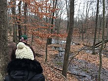
The park is a 265-acre (1.07 km2) nature preserve, comprising wetlands, ponds, sand barrens, spring-fed streams, and woodlands. It includes pitch pine woods, and rare wildflowers such as cranberry, lizard-tail, possumhaw, and bog twayblade. The animal species found in the park include northern black racer snakes, box turtles, eastern fence lizards, Fowler's toads, green frogs, and spring peepers. More than 170 bird species have been sighted in the park. Deer are also regularly seen there.
The purpose of the preserve is to retain the site's unique ecology, as well as to provide educational and recreational opportunities, such a nature walks, pond ecology programs, and birdwatching. Two hiking trails – the Abraham's Pond Trail and the Ellis Swamp Trail – are open to the public near the park headquarters, and horseback riding is permitted on five miles (8.0 km) of bridle paths.
The park has two designated areas, which are set aside for endangered species and are off-limits to the public.[3]
See also
References
- ^ "Clay Pit Ponds State Park Preserve". NYS Office of Parks, Recreation & Historic Preservation. Retrieved January 3, 2016.
- ^ a b "Section O: Environmental Conservation and Recreation, Table O-9". 2014 New York State Statistical Yearbook (PDF). The Nelson A. Rockefeller Institute of Government. 2014. p. 671. Archived from the original (PDF) on September 16, 2015. Retrieved April 9, 2016.
- ^ a b c d "Discover New York City's Great Natural Places – Staten Island". New York League of Conservation Voters. Archived from the original on November 10, 2005. Retrieved January 3, 2016.
- ^ "State Park Annual Attendance Figures by Facility: Beginning 2003". Data.ny.gov. Retrieved January 3, 2016.
- ^ "Clay Pit Ponds State Park". Geographic Names Information System. United States Geological Survey, United States Department of the Interior. Retrieved January 3, 2016.
- ^ a b Nyback, Glenn (May 5, 2007). "Mother Nature, get ready for your closeup". Staten Island Advance.
- ^ Lee, Jamie (February 26, 2009). "A new way to look at nature at Staten Island's Clay Pit Ponds". Staten Island Advance. Retrieved August 8, 2009.
External links
Wikimedia Commons has media related to Clay Pit Ponds State Park Preserve.
- New York State Parks: Clay Pit Ponds State Park Preserve
- v
- t
- e
Protected areas of New York
| |||||||||||||||||
Preserves and sanctuaries | |||||||
|---|---|---|---|---|---|---|---|
| |||||||
Other (lists) | |
|---|---|


