Churchtown, Pennsylvania
Census-designated place in Pennsylvania, United States
40°7′59″N 75°57′53″W / 40.13306°N 75.96472°W / 40.13306; -75.96472[1]
(2020)[2]
17555
Churchtown is an unincorporated community and census-designated place (CDP) in Caernarvon Township, Lancaster County, Pennsylvania, United States, along Pennsylvania Route 23. The population was 470 as of the 2010 census.[4]
History
The first settlers of the oldest Amish settlement still in existence, the Lancaster Amish settlement, settled near Churchtown.[5]
The Bangor Episcopal Church, Caernarvon Presbyterian Church and Edward Davies House are listed on the National Register of Historic Places.[6]
Geography
Churchtown is in eastern Lancaster County, in the center of Caernarvon Township. Pennsylvania Route 23 is the community's Main Street, leading east 4 miles (6 km) to Morgantown and west 20 miles (32 km) to Lancaster, the county seat.
According to the U.S. Census Bureau, the Churchtown CDP has a total area of 1.9 square miles (4.9 km2), of which 0.02 square miles (0.04 km2), or 0.71%, are water.[7] The community sits on a ridge draining south to the Conestoga River, a west-flowing tributary of the Susquehanna River.
-
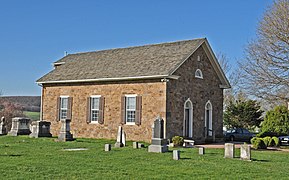 Caernarvon Presbyterian Church
 -
 Edward Davies House


Demographics
| Census | Pop. | Note | %± |
|---|---|---|---|
| 2020 | 417 | — | |
| U.S. Decennial Census[8][2] | |||
References
- ^ "ArcGIS REST Services Directory". United States Census Bureau. Retrieved October 12, 2022.
- ^ a b "Census Population API". United States Census Bureau. Retrieved Oct 12, 2022.
- ^ U.S. Geological Survey Geographic Names Information System: Churchtown, Pennsylvania
- ^ "Total Population: 2010 Census DEC Summary File 1 (P1), Churchtown CDP, Pennsylvania". data.census.gov. U.S. Census Bureau. Retrieved September 18, 2020.
- ^ "6 Takeaways from Our Conversation with Don Kraybill" at lancasteronline.com.
- ^ "National Register Information System". National Register of Historic Places. National Park Service. March 13, 2009.
- ^ "2019 U.S. Gazetteer Files: Places: Pennsylvania". United States Census Bureau. Retrieved September 18, 2020.
- ^ "Census of Population and Housing". Census.gov. Retrieved June 4, 2016.
- v
- t
- e
Municipalities and communities of Lancaster County, Pennsylvania, United States
County seat: Lancaster

- Bart
- Brecknock
- Caernarvon
- Clay
- Colerain
- Conestoga
- Conoy
- Drumore
- Earl
- East Cocalico
- East Donegal
- East Drumore
- East Earl
- East Hempfield
- East Lampeter
- Eden
- Elizabeth
- Ephrata
- Fulton
- Lancaster
- Leacock
- Little Britain
- Manheim
- Manor
- Martic
- Mount Joy
- Paradise
- Penn
- Pequea
- Providence
- Rapho
- Sadsbury
- Salisbury
- Strasburg
- Upper Leacock
- Warwick
- West Cocalico
- West Donegal
- West Earl
- West Hempfield
- West Lampeter
- Bainbridge
- Bird-in-Hand
- Blue Ball
- Bowmansville
- Brickerville
- Brownstown
- Cambridge‡
- Churchtown
- Clay
- Conestoga
- East Earl
- Falmouth
- Farmersville
- Fivepointville
- Gap
- Georgetown
- Goodville
- Gordonville
- Hinkletown
- Hopeland
- Intercourse
- Kirkwood
- Lampeter
- Landisville
- Leola
- Little Britain
- Maytown
- Morgantown‡
- Paradise
- Penryn
- Reamstown
- Refton
- Reinholds
- Rheems
- Rohrerstown
- Ronks
- Rothsville
- Salunga
- Schoeneck
- Smoketown
- Soudersburg
- Stevens
- Swartzville
- Wakefield
- Washington Boro
- Willow Street
- Witmer
communities
- Andrews Bridge
- Bartville
- Bausman
- Beartown
- Bellemont
- Bethesda
- Blainsport
- Buck
- Cains
- Central Manor
- Chickies
- Cocalico
- Conewago
- Creswell
- Dillerville
- Drumore
- Elm
- Fertility
- Florin
- Hempfield
- Holtwood
- Hunsecker
- Kinzers
- Kirks Mills
- Kissel Hill
- Leaman Place
- Lyndon
- Martic Forge
- Marticville
- Martindale
- Mastersonville
- Mechanics Grove
- Narvon
- New Danville
- New Milltown
- New Providence
- Neffsville
- Nickel Mines
- Ninepoints
- Oregon
- Peach Bottom
- Pequea
- Rawlinsville
- Safe Harbor
- Silver Spring
- Spring Garden
- Talmage
- West Willow
- White Horse
‡This populated place also has portions in an adjacent county or counties
- Pennsylvania portal
- United States portal


