Arbour Hill
Inner city area of Dublin, Ireland
Inner city area in Dublin, Ireland
Arbour Hill Chnoc an Arbhair | |
|---|---|
Inner city area | |
 Clockwise from top: National Museum of Ireland at Collins Barracks; Arbour Hill terraced housing; the cloisters at Collins Barracks; an independent publishing house and bookshop | |
| 53°21′01″N 6°17′0″W / 53.35028°N 6.28333°W / 53.35028; -6.28333 | |
| Country | Ireland |
| County | Dublin |
| City | Dublin |
| Postal district | D7 |
Arbour Hill (Irish: Cnoc an Arbhair[1]) is an area of Dublin within the inner city on the Northside of the River Liffey, in the Dublin 7 postal district. Arbour Hill, the road of the same name, runs west from Blackhall Place in Stoneybatter, and separates Collins Barracks, now hosting part of the National Museum of Ireland, to the south from Arbour Hill Prison to the north,[2] whose graveyard includes the burial plot of the signatories of the Easter Proclamation and other leaders executed after the 1916 Rising. St Bricin's Military Hospital, formerly the King George V Hospital, is also located in Arbour Hill.
History
Arbour Hill is derived from the Irish Cnoc an Arbhair which means "corn hill". The area was owned by Christ Church Cathedral during the medieval period and was used to store corn.[2] The area first appears on a map in 1603 as "Earber-hill".[3]
As part of his commissioned symphonic work "Irishmen and Irishwomen", the composer Vincent Kennedy included a movement titled "Arbour Hill".[4] This movement is a tribute to the Easter Rising participants buried at Arbour Hill.[5]
Gallery
-
 Church of the Sacred Heart, Arbour Hill
 -
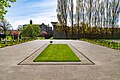 1916 memorial garden at Arbour Hill
 -
 1916 memorial wall at Arbour Hill
 -
 Wreath laying ceremony at the 1916 memorial garden at Arbour Hill


References
- ^ "Arbour Hill/Cnoc an Arbhair". Placenames Database of Ireland. Retrieved 8 April 2011.
- ^ a b Clerkin, Paul (2001). Dublin street names. Dublin: Gill & Macmillan. pp. 5–6. ISBN 0-7171-3204-8. OCLC 48467800.
- ^ M'Cready, C. T. (1987). Dublin street names dated and explained. Blackrock, Co. Dublin: Carraig. p. 3. ISBN 1-85068-005-1. OCLC 263974843.
- ^ "'Irishmen and Irishwomen': For 1916 from 2016".
- ^ "Textura".
- v
- t
- e
(Northside)
- Abbey Street
- Amiens Street
- Arbour Hill
- Bachelors Walk
- Benburb Street
- Beresford Place
- Blackhall Place
- Bloom Lane
- Buckingham Street
- Capel Street
- Cathal Brugha Street
- Cathedral Street
- Clonliffe Road
- Dominick Street
- Dorset Street
- East Wall Road
- Eccles Street
- Eden Quay
- Foley Street
- Gardiner Street
- Great Denmark Street
- Henrietta Street
- Henry Street
- Home Farm Road
- Jervis Street
- Marino Crescent
- Marlborough Street
- Mary Street
- Moore Street
- North Circular Road
- North Earl Street
- North Frederick Street
- North Great George's Street
- North Strand Road
- O'Connell Street
- Parnell Street
- Queen Street
- Seán McDermott Street
- Sheriff Street
- Store Street
- Summerhill Parade
- Talbot Street
(Southside)
- Ailesbury Road
- Anglesea Road
- Aungier Street
- Baggot Street
- Bow Lane West
- Boyne Street
- Bride Street
- Britain Quay
- Bull Alley Street
- Camden Street
- Christchurch Place
- Clanbrassil Street
- Clare Street
- Clyde Road
- College Green
- College Street
- The Coombe
- Coppinger Row
- Cork Street
- Crampton Court
- Cuffe Street
- Dame Lane
- Dame Street
- Dawson Street
- D'Olier Street
- Earlsfort Terrace
- Ely Place
- Eustace Street
- Fenian Street
- Fishamble Street
- Fleet Street
- Fownes Street
- Fumbally Lane
- Georges Quay
- Golden Lane
- Grafton Street
- Harcourt Street
- Harcourt Terrace
- Hawkins Street
- Herbert Park
- Herbert Road
- Heytesbury Street
- High Street
- Hume Street
- James's Street
- Kildare Street
- Lansdowne Road
- Leeson Street
- Lincoln Place
- Marrowbone Lane
- Merrion Road
- Merrion Street
- Misery Hill
- Molesworth Street
- Morehampton Road
- Mount Street Lower
- Nassau Street
- Northumberland Road
- Newbridge Avenue
- New Bride Street
- Park Avenue
- Parliament Street
- Patrick Street
- Pearse Street
- Raglan Road
- Sandymount Avenue
- Shelbourne Road
- Ship Street Little
- Shrewsbury Road
- Sir John Rogerson's Quay
- South Circular Road
- South Great George's Street
- South William Street
- St Andrew's Street
- Steeven's Lane
- Stephen Street
- Sydney Parade Avenue
- Tara Street
- Thomas Street
- Tritonville Road
- Werburgh Street
- Westland Row
- Westmoreland Street
- Wexford Street
- Wicklow Street
- Winetavern Street
- Wood Quay
- York Street
 | This geographical article about the Dublin area is a stub. You can help Wikipedia by expanding it. |
- v
- t
- e


 Arbour_Hill