Albion Falls
Waterfall in Hamilton, Ontario
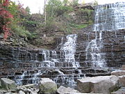
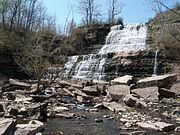
43°12′02″N 79°49′11″W / 43.2004722°N 79.8196778°W / 43.2004722; -79.8196778Albion Falls is a 19 m (62 ft) classical/cascade waterfall flowing down the Niagara Escarpment in Red Hill Valley, in Hamilton, Ontario, Canada. With cascade falls the downpour is staggered into a series of steps causing water to "cascade". The top of the falls are located on Mountain Brow Blvd. The lower-end of the falls can be found at the south-end of King's Forest Park in lower Hamilton by following the Red Hill Creek south towards the Niagara Escarpment.[1]
Albion Falls was once seriously considered as a possible source of water for Hamilton. Rocks from the Albion Falls area were used in the construction of the Royal Botanical Gardens' Rock Garden.[2]
The ravine at the Albion Falls has a legend of the Lover's Leap. The story is that early in the 19th century young Jane Riley, disappointed in love with Joseph Rousseau, stood at the top of a steep cliff not far from thundering Albion Falls and flung herself to the bottom 100 ft (30 m) below. The steep drop has since been dubbed "Lovers' Leap" and many tales have grown up about the suicide.[3]
Nearby attractions include the Bruce Trail, Buttermilk Falls, Devil's Punch Bowl, Felker's Falls, Confederation Park (via Red Hill Trail), Mohawk 4 Ice Centre at Mohawk Sports Park, scenic views of lower Hamilton, King's Forest Golf Course and Park, Gage Park and Hamilton Children's Museum.
Directions
To reach Albion Falls via a walking trail, take the Escarpment Rail Trail or the Albion Side Trail of the Bruce Trail.
To reach Albion Falls by car, exit on Dartnell Road from the Lincoln M. Alexander Parkway. Go south on Dartnell, then go left onto Stone Church Road East. Turn left onto Pritchard Road, then left again onto Mud Street. You will find two parking lots available on either side of Mud Street where it connects with Mountain Brow Boulevard.
You can also reach it by taking Mohawk Road till it ends at the Escarpment, then take the road around the brow and it will be on the left side. You can also take Limeridge Road East till it dead ends at the brow, then turn left and then a quick right into the parking lot.
Note: Due to the completion of the Red Hill Valley Parkway, you can no longer reach Albion Falls via Mud Street.
Images
Albion Falls
-
 Albion Falls, King's Forest Park
 -
 Albion Falls, King's Forest Park
 -
 Albion Falls, King's Forest Park
 -
 Albion Falls in April 2008
 -
 Albion Falls in Winter


See also
References
- ^ "Hamilton- Waterfall Capital of the World". (www.cityofwaterfalls.ca). Archived from the original on 25 May 2008. Retrieved 2008-07-09.
- ^ "Hamilton Conservation Authority: Parks & Attractions- Albion Falls". Archived from the original on 2008-07-18. Retrieved 2008-06-17.
- ^ "Great Lakes Waterfalls & Beyond- Albion Falls". Archived from the original on 4 July 2008. Retrieved 2008-06-17.
External links
Wikimedia Commons has media related to Albion Falls.
Wikivoyage has a listing for Albion Falls.
- Waterfalls of Ontario: Albion Falls
- Albion Falls: Photos and Updated Information
- Albion Falls (www.start.ca)
- Legend of Lover's Leap (www.hauntedhamilton.com)
- Cascades and Waterfalls of Hamilton (www.waterfalls.hamilton.ca)
- Bruce Trail (www.brucetrail.org)
- Hamilton- "The Waterfall Capital of the World" (www.cityofwaterfalls.ca)
- Vintage Postcards: Waterfalls in and around Hamilton, Ontario Archived 2008-05-15 at the Wayback Machine
Maps
- Hamilton Waterfall Map PDF. (http://map.hamilton.ca)
- Map: Hamilton Waterfalls (www.hamiltonnature.org)
- v
- t
- e
 Hamilton, Ontario
- 1930 British Empire Games
- Auchmar
- Bank of Hamilton
- Battlefield House
- Battle of Stoney Creek
- Dundurn Castle
- George Hamilton
- Grand Lodge of Canada
- Hamilton Tigers (NHL)
- HMCS Haida
- List of National Historic Sites
- List of royal visits
- Studebaker Canada
- Tim Hortons
- Thomas McQuesten
- Timeline of events
- Toronto, Hamilton and Buffalo Railway
- USS Hamilton
- USS Scourge
- War of 1812
- Whitehern
- List of waterfalls
- Bruce Trail
- Cootes Paradise
- Desjardins Canal
- Golden Horseshoe
- Greater Toronto and Hamilton Area
- Hamilton Harbour
- Lake Ontario
- Niagara Escarpment
- Royal Botanical Gardens
- Spencer Gorge/Webster's Falls Conservation Area
- Twenty Mile Creek
- African Lion Safari
- Around the Bay Road Race
- Art Gallery of Hamilton
- Canadian Football Hall of Fame
- Canadian Warplane Heritage Museum
- Dundas Cactus Festival
- Hamilton Bulldogs
- Hamilton Tiger-Cats
- Labour Day Classic
- List of Attractions in Hamilton
- Media in Hamilton
- Pride Hamilton
- Power Play (TV series)
- Sports in Hamilton
- Supercrawl
- Sports venues in Hamilton
- Bayfront Park
- Beasley Park
- Confederation Beach Park
- Gore Park
- Hamilton–Brantford–Cambridge Trails
- Mohawk Sports Park
- Pier 4 Park


