Aalsum, Groningen
Hamlet in Groningen, Netherlands
53°18′25″N 6°22′12″E / 53.30694°N 6.37000°E / 53.30694; 6.37000 Netherlands
 Groningen
 Westerkwartier
9883
Aalsum (Dutch pronunciation: [ˈaːlsʏm]) is a small hamlet in the Dutch province of Groningen. It is located in the municipality of Westerkwartier, about 1.5 km west of Oldehove.[1]
The hamlet was located on a wierde, an artificial dwelling hill. The hill was partially excavated in the 20th century; a bow from the ninth century was found. Plans to reconstruct the hill were canceled.
According to the 19th-century historian A.J. van der Aa,[2] Aalsum had 80 inhabitants in the middle of the 19th century; presumably, this includes the surrounding countryside.
Gallery
-
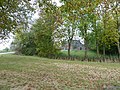
 Wierde seen from the Aalsumerweg from the direction of Kommerzijl
 -
 Wierde seen from the Aalsumerweg from the direction of Oldehove
 -
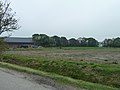 Wierde seen from the Electraweg


References
- ^ ANWB Topografische Atlas Nederland, Topografische Dienst and ANWB, 2005.
- ^ Abraham Jacob van der Aa, "Aardrijkskundig woordenboek der Nederlanden", vol. 1 (A), 1839.
External links
![]() Media related to Aalsum (Groningen) at Wikimedia Commons
Media related to Aalsum (Groningen) at Wikimedia Commons
- v
- t
- e
Populated places in the municipality of Westerkwartier
- Aduard
- Boerakker
- Briltil
- Den Ham
- Den Horn
- De Wilp
- Doezum
- Enumatil
- Ezinge
- Feerwerd
- Garnwerd
- Grijpskerk
- Grootegast
- Jonkersvaart
- Kommerzijl
- Kornhorn
- Lauwerzijl
- Leek
- Lettelbert
- Lucaswolde
- Lutjegast
- Marum
- Midwolde
- Niebert
- Niehove
- Niekerk
- Niezijl
- Noordhorn
- Noordwijk
- Nuis
- Oldehove
- Oldekerk
- Oostwold
- Opende
- Pieterzijl
- Saaksum
- Sebaldeburen
- Tolbert
- Visvliet
- Zevenhuizen
- Zuidhorn
- Aalsum
- Aduarderzijl
- Fransum
- Oostum
53°18′27″N 6°22′10″E / 53.30750°N 6.36944°E / 53.30750; 6.36944
 | This Groningen location article is a stub. You can help Wikipedia by expanding it. |
- v
- t
- e


