120th meridian west
Line of longitude

120°
class=notpageimage|
120th meridian westMap all coordinates using OpenStreetMap
Download coordinates as:
- KML
- GPX (all coordinates)
- GPX (primary coordinates)
- GPX (secondary coordinates)
The meridian 120° west of Greenwich is a line of longitude that extends from the North Pole across the Arctic Ocean, North America, the Pacific Ocean, the Southern Ocean, and Antarctica to the South Pole.
The 120th meridian west forms a great circle with the 60th meridian east.
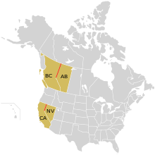
In Canada the border between British Columbia and Alberta is defined by the meridian north of where it intersects the Continental Divide of the Americas, and in the United States part of the border between California and Nevada follows it.
The mean solar time at this meridian determines the time for the Pacific Time Zone (UTC−08:00) during standard time. Most of the year however, it is the meridian for Alaska Daylight Time, as daylight saving time is observed for two-thirds of the year.
From Pole to Pole
Starting at the North Pole and heading south to the South Pole, the 120th meridian west passes through:
Co-ordinates Country, territory or sea Notes 90°0′N 120°0′W / 90.000°N 120.000°W / 90.000; -120.000 (Arctic Ocean) Arctic Ocean 77°1′N 120°0′W / 77.017°N 120.000°W / 77.017; -120.000 (Canada)  Canada
 Northwest Territories — Prince Patrick Island 75°50′N 120°0′W / 75.833°N 120.000°W / 75.833; -120.000 (M'Clure Strait) M'Clure Strait 74°17′N 120°0′W / 74.283°N 120.000°W / 74.283; -120.000 (Canada) Canada Northwest Territories — Banks Island 72°14′N 120°0′W / 72.233°N 120.000°W / 72.233; -120.000 (Prince of Wales Strait) Prince of Wales Strait 71°32′N 120°0′W / 71.533°N 120.000°W / 71.533; -120.000 (Amundsen Gulf) Amundsen Gulf 69°21′N 120°0′W / 69.350°N 120.000°W / 69.350; -120.000 (Canada) Canada Nunavut
Northwest Territories — passing through Great Bear Lake
British Columbia / Alberta border — from 60°0′N 120°0′W / 60.000°N 120.000°W / 60.000; -120.000 (British Columbia/Alberta border)
British Columbia — from Intersection Mountain at 53°48′N 120°0′W / 53.800°N 120.000°W / 53.800; -120.000 (British Columbia); at this point the meridian meets the Continental Divide, and the boundary with Alberta diverts southeast49°0′N 120°0′W / 49.000°N 120.000°W / 49.000; -120.000 (United States)  United States
 Washington
Oregon — from 45°49′N 120°0′W / 45.817°N 120.000°W / 45.817; -120.000 (Oregon)
California / Nevada border — from 42°0′N 120°0′W / 42.000°N 120.000°W / 42.000; -120.000 (Oregon)
California — from 39°0′N 120°0′W / 39.000°N 120.000°W / 39.000; -120.000 (California), through South Lake Tahoe and just east of Madera34°27′N 120°0′W / 34.450°N 120.000°W / 34.450; -120.000 (Pacific Ocean) Pacific Ocean Santa Barbara Channel 33°59′N 120°0′W / 33.983°N 120.000°W / 33.983; -120.000 (United States) United States California — Santa Rosa Island 33°57′N 120°0′W / 33.950°N 120.000°W / 33.950; -120.000 (Pacific Ocean) Pacific Ocean 60°0′S 120°0′W / 60.000°S 120.000°W / -60.000; -120.000 (Southern Ocean) Southern Ocean 73°44′S 120°0′W / 73.733°S 120.000°W / -73.733; -120.000 (Antarctica) Antarctica Unclaimed territory


See also
References
- v
- t
- e
Circles of latitude / meridians

Equator
Tropic of Cancer
Tropic of Capricorn
Arctic Circle
Antarctic Circle
Equator
Tropic of Cancer
Tropic of Capricorn
Arctic Circle
Antarctic Circle
90°
180°
90°
120°
180°
45°
45°
45x90
45x90
45x90
45x90


