Liste der Einträge im National Register of Historic Places im Marshall County (Mississippi)

Die Liste der Einträge im National Register of Historic Places im Marshall County in Mississippi führt die Bauwerke und historischen Stätten im Marshall County auf, die in das National Register of Historic Places aufgenommen wurden.[1]
| [2] | Name[3] | Bild | Eintragsdatum | Lage | Ort | Beschreibung |
|---|---|---|---|---|---|---|
| 1 | Dr. Isham G. Bailey House |  | 2001 ID-Nr. 01000919 | 1577 Early Grove Road 34° 59′ 17″ N, 89° 22′ 41″ W34.988056-89.378056 | westlich von Lamar | |
| 2 | Byhalia Historic District |  | 1996 ID-Nr. 96000256 | Abgegrenzt durch Church Street, Chulahoma Street und Senter Street 34° 52′ 10″ N, 89° 41′ 27″ W34.869444-89.690833 | Byhalia | |
| 3 | Byhalia United Methodist Church | 1984 ID-Nr. 84002276 | College Avenue 34° 52′ 12″ N, 89° 41′ 31″ W34.87-89.691944 | Byhalia | ||
| 4 | Chalmers Institute | 1982 ID-Nr. 82003107 | West Chulahoma Avenue 34° 46′ 1″ N, 89° 27′ 25″ W34.766944-89.456944 | Holly Springs | ||
| 5 | Civil War Earthworks at Tallahatchie Crossing |  | 1973 ID-Nr. 73001021 | Abseits des Mississippi Highway 7 34° 33′ 25″ N, 89° 29′ 16″ W34.556944-89.487778 | nördlich von Abbeville | |
| 6 | Confederate Armory Site | 1972 ID-Nr. 72000699 | nördlich von Holly Springs 34° 46′ 43″ N, 89° 23′ 40″ W34.778611-89.394444 | Holly Springs | ||
| 7 | Depot-Compress Historic District | 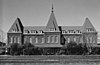 | 1983 ID-Nr. 83000959 | Abgegrenzt von den Eisenbahngleisen, der Chesterman Street, der College Avenue und der Van Dorn Avenue 34° 46′ 5″ N, 89° 26′ 7″ W34.768056-89.435278 | Holly Springs | |
| 8 | East Holly Springs Historic District |  | 1983 ID-Nr. 83000960 | Abgegrenzt durch Compress Street, Chesterman Street, Randolph Street, Spring Street, Salem Avenue und Van Dorn Avenue 34° 46′ 11″ N, 89° 26′ 27″ W34.769722-89.440833 | Holly Springs | |
| 9 | Hillcrest Cemetery |  | 1982 ID-Nr. 82003108 | Center Street 34° 45′ 46″ N, 89° 26′ 47″ W34.762778-89.446389 | Holly Springs | |
| 10 | Holly Springs Courthouse Square Historic District |  | 1980 ID-Nr. 80004550 | U.S. Highway 78 34° 46′ 5″ N, 89° 26′ 52″ W34.768056-89.447778 | Holly Springs | |
| 11 | McCoy Administration Building | 1998 ID-Nr. 98000254 | 150 East Rust Avenue 34° 46′ 34″ N, 89° 26′ 49″ W34.776111-89.446944 | Holly Springs | ||
| 12 | Mississippi Industrial College Historic District |  | 1980 ID-Nr. 80002290 | Memphis Street 34° 46′ 32″ N, 89° 26′ 57″ W34.775556-89.449167 | Holly Springs | |
| 13 | Myers-Hicks Place |  | 1983 ID-Nr. 83000961 | Mississippi Highway 309 34° 49′ 47″ N, 89° 41′ 19″ W34.829722-89.688611 | Byhalia | |
| 14 | North Memphis Street Historic District | 1983 ID-Nr. 83000962 | Abgegrenzt durch North Memphis Street, Falconer Avenue, Salem Avenue und Park Avenue 34° 46′ 13″ N, 89° 26′ 55″ W34.770278-89.448611 | Holly Springs | ||
| 15 | Oakview | 1982 ID-Nr. 82003110 | Rust Avenue am Campus des Rust College 34° 46′ 32″ N, 89° 26′ 46″ W34.775556-89.446111 | Holly Springs | ||
| 16 | Old Water and Electric Light Plant |  | 1982 ID-Nr. 82003111 | 140 East Falconer Avenue 34° 46′ 9″ N, 89° 26′ 50″ W34.769167-89.447222 | Holly Springs | |
| 17 | Robert Raiford Home and Farm | 1998 ID-Nr. 98001110 | 829 Cayce Road 34° 52′ 10″ N, 89° 37′ 37″ W34.869444-89.626944 | Victoria | ||
| 18 | Southwest Holly Springs Historic District |  | 1983 ID-Nr. 83000963 | Abgegrenzt durch South Center Street, South Memphis Street, Craft Street, Marbury Ct., Chulahoma Avenue, Gholson Avenue, Elder Avenue und Mason Avenue 34° 45′ 51″ N, 89° 27′ 4″ W34.764167-89.451111 | Holly Springs | |
| 19 | Summer Trees | 1979 ID-Nr. 79001331 | Nordöstlich von Red Banks an der Mayhome Road 34° 52′ 5″ N, 89° 32′ 54″ W34.868056-89.548333 | Red Banks | ||
| 20 | Wall Doxey State Park |  | 1997 ID-Nr. 97001437 | Zwischen dem Mississippi Highway 7 und dem Spring Lake 34° 39′ 51″ N, 89° 27′ 40″ W34.664167-89.461111 | Holly Springs |
Siehe auch
- Liste der National Historic Landmarks in Mississippi
- National Register of Historic Places in Mississippi
Einzelnachweise
- ↑ Auszug aus dem National Register of Historic Places - Marshall County Abgerufen am 22. September 2012
- ↑ Die Nummerierung in dieser Listenspalte ist an der vom National Park Service vorgelegten Reihenfolge der Einträge orientiert; die Farben unterscheiden verschiedene Schutzgebietstypen des Nationalparksystems mit landesweiter Bedeutung (z. B. National Historic Landmarks) von den sonstigen Einträgen im National Register of Historic Places.
- ↑ National Register Information System. In: National Register of Historic Places. National Park Service, abgerufen am 24. April 2008 (englisch).

Einträge im National Register of Historic Places in Mississippi
National Register of Historic Places in Mississippi
Adams | Alcorn | Amite | Attala | Benton | Bolivar | Calhoun | Carroll | Chickasaw | Choctaw | Claiborne | Clarke | Clay | Coahoma | Copiah | Covington | DeSoto | Forrest | Franklin | George | Greene | Grenada | Hancock | Harrison | Hinds | Holmes | Humphreys | Issaquena | Itawamba | Jackson | Jasper | Jefferson | Jefferson Davis | Jones | Kemper | Lafayette | Lamar | Lauderdale | Lawrence | Leake | Lee | Leflore | Lincoln | Lowndes | Madison | Marion | Marshall | Monroe | Montgomery | Neshoba | Newton | Noxubee | Oktibbeha | Panola | Pearl River | Perry | Pike | Pontotoc | Prentiss | Quitman | Rankin | Scott | Sharkey | Simpson | Smith | Stone | Sunflower | Tallahatchie | Tate | Tippah | Tishomingo | Tunica | Union | Walthall | Warren | Washington | Wayne | Webster | Wilkinson | Winston | Yalobusha | Yazoo


